Autonomous controllable multi-system high-precision navigation equipment and navigation method

A navigation device, high-precision technology, used in the field of communications

Active Publication Date: 2021-07-06
北京云恒科技研究院有限公司
View PDF6 Cites 1 Cited by
  • Summary
  • Abstract
  • Description
  • Claims
  • Application Information

AI Technical Summary

Problems solved by technology

Also, it is unlikely that there will always be a receiver with known coordinates nearby while the device is in use

Method used


Image

  • Autonomous controllable multi-system high-precision navigation equipment and navigation method
  • Autonomous controllable multi-system high-precision navigation equipment and navigation method
  • Autonomous controllable multi-system high-precision navigation equipment and navigation method

Examples


Embodiment 1

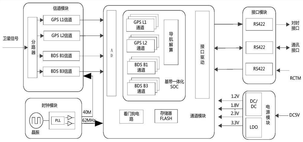
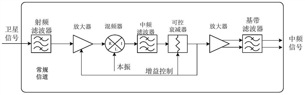
[0054] The autonomously controllable dual-system high-precision navigation device in this embodiment includes a power supply module, a clock module, a channel module, a channel module and an interface module. The power supply module is used to supply power to the clock module, channel module, channel module, and interface module; the clock module is used to provide a clock reference for the channel module and the channel module; the channel module is used to use different channels for GPS signals and Beidou signals Receive, amplify, and down-convert the frequency, and send the down-converted intermediate frequency signal to the channel module for digital domain processing after AD sampling; the channel module is used to quickly capture, track, and demodulate GPS signals and Beidou signals. Navigation and positioning of GPS signals and Beidou signals; the interface module is used for communicating with the outside.

[0055] The power supply module can include DC / DC circuit, LDO...

Embodiment 2

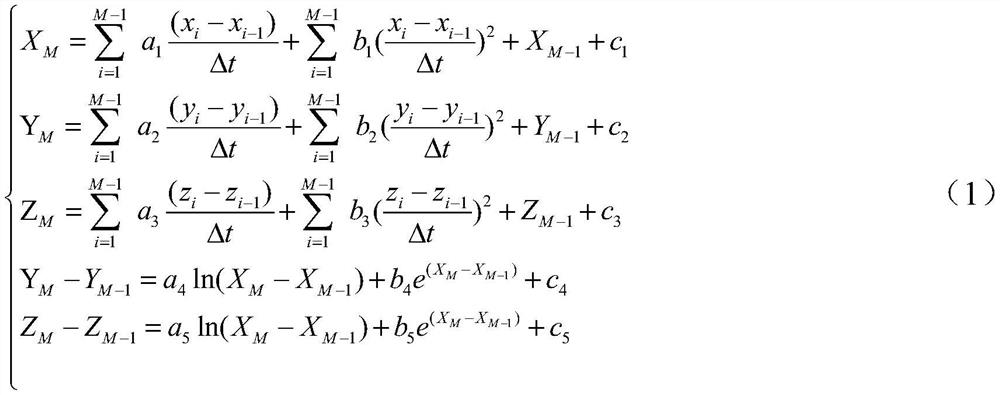
[0062] In this embodiment, a new navigation calculation method that can be realized by using the navigation device in Embodiment 1 or other dual-system navigation devices is provided.

[0063] Although the system configuration is given in Embodiment 1, the calculation method adopted by this system configuration still continues the existing calculation method.

[0064]Moreover, although GPS and BDS two positioning systems are used for positioning, and the two are mutually verified, the accuracy can be improved. However, when the two positioning systems encounter signal jumps, one of the signal quality is very poor, or both signal quality When it is very poor, it is easy to have a large deviation of the positioning position, and it is difficult to determine which of the two positioning methods has the higher accuracy of the positioning system, which affects the positioning stability. In addition, when the ambiguity resolution method is used for solving, the calculation amount is...


PUM


Abstract

The invention relates to autonomous controllable multi-system high-precision navigation equipment and a navigation method, and belongs to the technical field of positioning navigation. The system comprises a signal channel module, a channel module, a clock module, a power supply module and an interface module. The power supply module is used for supplying power to each module; the clock module is used for providing a clock reference for the signal channel module and the channel module; the signal channel module is used for performing digital conversion on a GPS signal and a Beidou signal by using different signal channels; and a navigation resolving module is used for carrying out navigation resolving on the GPS signal and the Beidou signal and carrying out navigation positioning based on the GPS signal and the Beidou signal. According to the invention, through dual-system redundancy, the positioning precision is improved; and meanwhile, by optimizing the device, the completely autonomous and controllable full-localization design is realized.

Description

technical field [0001] The invention relates to the communication field, in particular to a nationally produced high-precision navigation device and a navigation method. Background technique [0002] China's BeiDou Navigation Satellite System (BDS) is a global satellite navigation system developed by China itself. The Beidou satellite navigation system consists of three parts: the space segment, the ground segment and the user segment. Message communication capability (RDSS). RNSS signals are provided to public basic navigation services through four frequency points B1I, B1C, B2A, and B3I, and authorized navigation service signals are provided through four frequency points B1A, B3A, B3AE, and B3Q. [0003] GPS (Global Positioning System) is a comprehensive, all-weather, all-time, high-precision satellite navigation system developed and established by the U.S. Department of Defense, which can provide low-cost, high-precision three-dimensional position, speed and precise tim...

Claims


Application Information

Patent Timeline
Patent Type & Authority Applications(China)
IPC IPC(8): G01S19/43G01S19/13G01S19/37
CPCG01S19/43G01S19/13G01S19/37Y02D30/70
Inventor 韦博郑伟庞诚亢凯何东兴刘斌崔雨波王理
Owner 北京云恒科技研究院有限公司
Why Eureka
Try Eureka