Map updating system, method and equipment

A map update, map technology, applied in the direction of database update, geographic information database, special data processing applications, etc., can solve the problem of low map update accuracy, achieve low mobile device cost, high map update accuracy, and make up for the lack of accuracy Effect

Pending Publication Date: 2021-07-30
浙江菜鸟供应链管理有限公司
View PDF0 Cites 2 Cited by
  • Summary
  • Abstract
  • Description
  • Claims
  • Application Information

AI Technical Summary

Problems solved by technology

[0005] This application provides a map update system to solve the problem of low map update accuracy existing in the prior art

Method used


Image

  • Map updating system, method and equipment
  • Map updating system, method and equipment
  • Map updating system, method and equipment

Examples


no. 1 example

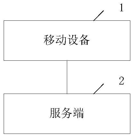
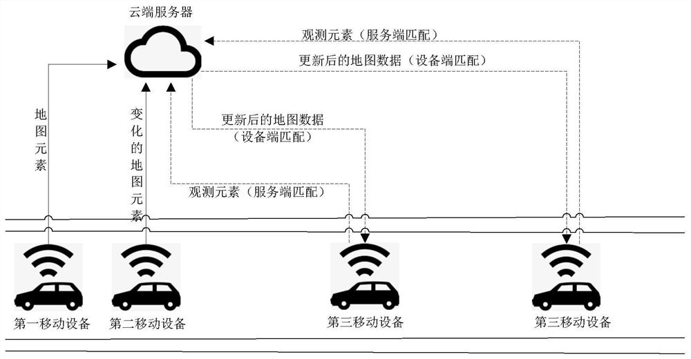
[0126] Please refer to figure 1 , which is a schematic structural diagram of an embodiment of a map updating system provided in this application. A map updating system provided in this application includes: a mobile device 1 and a server 2 .

[0127] The mobile device 1 includes, but is not limited to, mobile devices such as unmanned vehicles, mobile robots, drones, etc., and can also be manned mobile devices equipped with environmental perception sensors. The mobile device 1 can use a camera as an environment perception sensor to capture images of the surrounding environment, and determine characteristic elements of the surrounding environment according to the image data. The mobile device 1 can also use a positioning device equipped with a general self-driving vehicle to determine the pose data of the mobile device in real time. It can be seen that, compared with a special high-performance map-collecting vehicle (using lidar and the like to perceive the surrounding environ...

no. 2 example

[0190] In the foregoing embodiments, a system for updating a map is provided, and correspondingly, the present application also provides a method for updating a map. This method corresponds to the mobile device embodiment of the above method.

[0191] Please refer to Figure 9 , which is a flow chart of an embodiment of the map update method of the present application, the execution body of the method includes a map update device, and the device can be deployed on the mobile device 1 . Since the method embodiment is basically similar to the system embodiment 1, the description is relatively simple, and for relevant details, refer to the part of the description of the system embodiment 1. The method embodiments described below are illustrative only.

[0192] A method for updating a map in this embodiment includes:

[0193] Step S901: collect road environment image data, and determine the pose data of the mobile device at the moment of image collection.

[0194] Step S903: A...

no. 3 example

[0219] Please refer to Figure 12 , which is a schematic diagram of an embodiment of the map update device of the present application. Since the device embodiment is basically similar to the method embodiment, the description is relatively simple, and for relevant parts, refer to the part of the description of the method embodiment. The device embodiments described below are illustrative only.

[0220] A map updating device in this embodiment includes:

[0221]An image acquisition unit 1201, configured to acquire road environment image data;

[0222] A positioning unit 1203, configured to determine the pose data of the mobile device at the moment of image collection;

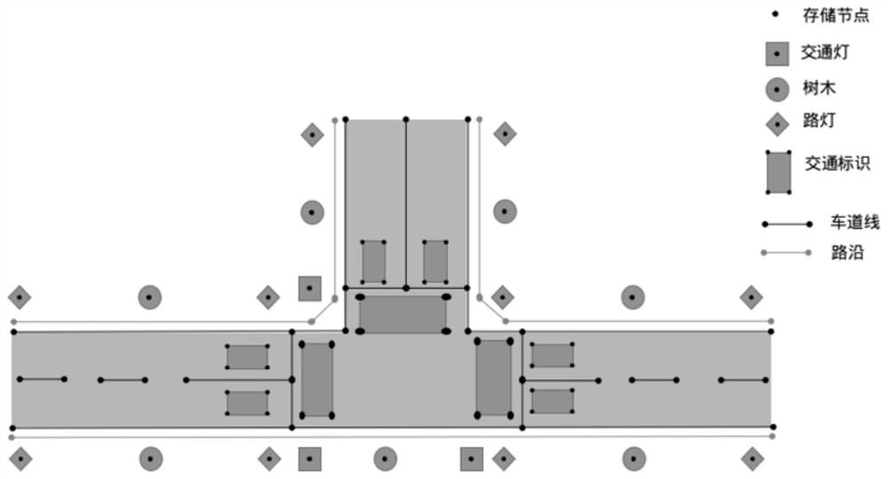
[0223] The multi-frame element registration unit 1205 is configured to determine the first corresponding relationship between the road feature observation elements of the road segment and the map elements according to the image data and the pose data at the current moment and multiple adjacent historical mome...


PUM


Abstract

The invention discloses a map updating system, a related method, a related device and related equipment. The map updating method comprises the following steps: acquiring road environment image data, and determining pose data of mobile equipment at an image acquisition moment; according to the image data and the pose data of the current moment and the plurality of historical moments, determining a first corresponding relation between the road feature observation elements of the road segments and map elements; adjusting the observation element at the current moment according to the first corresponding relation; and updating map elements corresponding to the pose data at the current moment according to the adjusted observation elements at the current moment. By adopting the processing mode, a camera sensor and a low-cost positioning device which are arranged on common mobile equipment are adopted, the accuracy of local relative measurement is improved, the defect that the accuracy of measurement of the camera sensor and the positioning device is insufficient is overcome, and real-time accurate change detection of map data of a mobile equipment end is achieved; therefore, relatively low cost of the mobile equipment and relatively high map updating accuracy can be taken into account.

Description

technical field [0001] The present application relates to the technical field of automatic driving, and specifically relates to a map updating system, method and device, electronic equipment, and mobile equipment. Background technique [0002] In mobile device positioning scenarios such as autonomous driving, indoor robots, and drones, mobile device positioning technology based on environmental maps can be used. Taking autonomous driving as an example, this technology allows the use of high-performance equipment or complex methods to obtain a map with a preset level of clarity in advance. During real-time positioning, the mobile device obtains real-time observation data through sensors, and then combines the observation data with the map. The data is registered to obtain the pose data of the mobile device. [0003] Map production can be divided into data collection, data processing, manual verification and other links. Among them, data collection requires a special data co...

Claims


Application Information

Patent Timeline
Patent Type & Authority Applications(China)
IPC IPC(8): G06F16/23G06F16/29
CPCG06F16/23G06F16/29
Inventor 颜扬治
Owner 浙江菜鸟供应链管理有限公司
Why Eureka
Try Eureka