Target-level semantic positioning method based on vehicle-mounted laser radar

A vehicle-mounted lidar and positioning method technology, applied in the field of high-level autonomous driving positioning, can solve problems such as reduced accuracy, and achieve the effects of wide application, solving positioning drift, and continuous stability and real-time performance.

Pending Publication Date: 2021-08-10
SOUTH CHINA UNIV OF TECH
View PDF6 Cites 5 Cited by
  • Summary
  • Abstract
  • Description
  • Claims
  • Application Information

AI Technical Summary

Problems solved by technology

[0004] 1. Since the navigation information is obtained by time integration, and the integration process will accumulate positioning errors, as a long-term positioning algorithm, its accuracy will gradually decrease;

Method used


Image

  • Target-level semantic positioning method based on vehicle-mounted laser radar
  • Target-level semantic positioning method based on vehicle-mounted laser radar
  • Target-level semantic positioning method based on vehicle-mounted laser radar

Examples


Embodiment

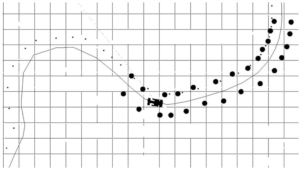
[0080] In this embodiment, in order to reduce costs and facilitate experimental testing, the present invention uses a control-by-wire chassis to simulate the application scene of a vehicle. Among them, the cone barrel is used to simulate the static target of interest. When collecting data, the remote-controlled chassis drives on a track formed by cones, simulating the scene where the vehicle follows the centerline of the structured road in the city. The experimental setup is for the convenience of explaining the details of the present invention, and the actual implementation of the present invention is not therefore limited to the following examples.

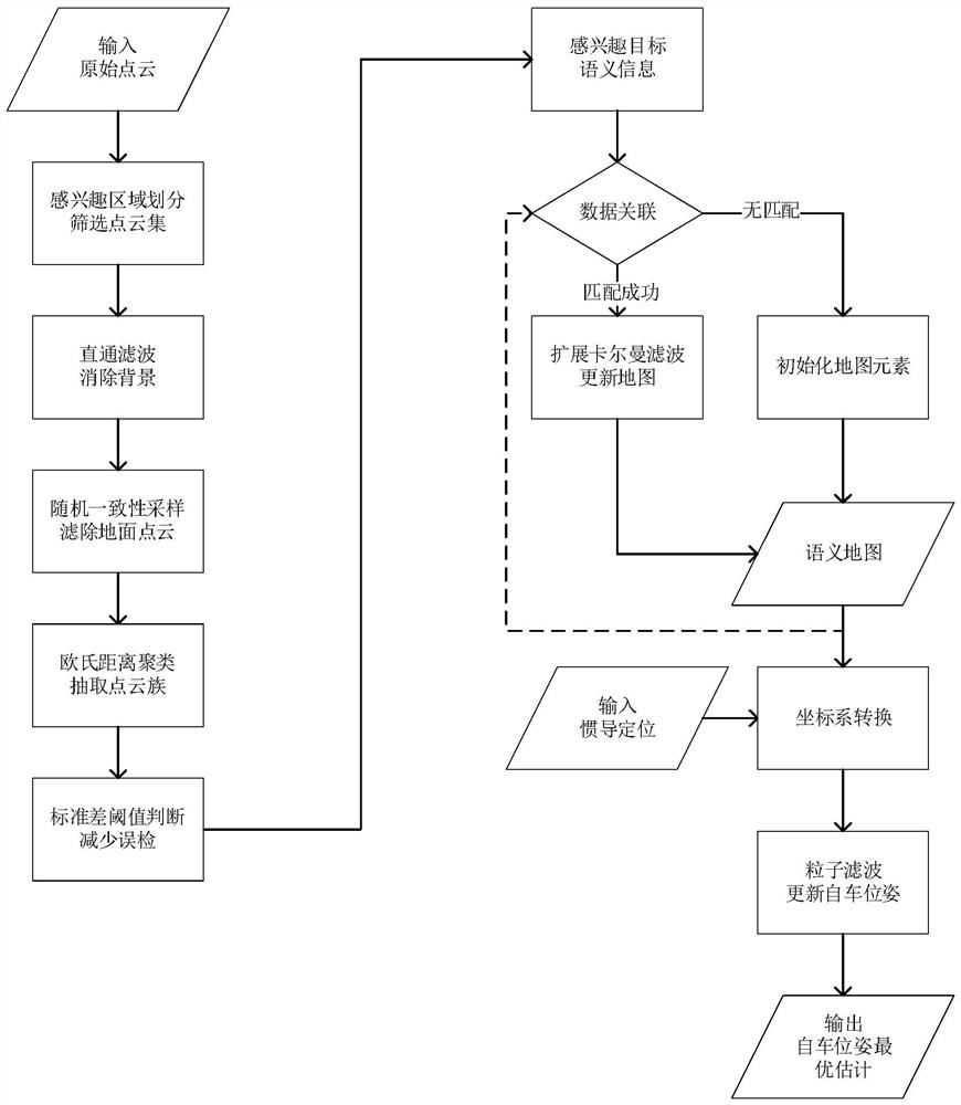
[0081] A target-level semantic localization method based on vehicle lidar, such as figure 1 shown, including the following steps:

[0082] S1. Use the vehicle-mounted lidar to scan the surrounding environment, collect point cloud data and preprocess, specifically including the following steps:

[0083] S1.1. Install the vehic...


PUM


Abstract

The invention discloses a target-level semantic positioning method based on a vehicle-mounted laser radar. The method comprises the following steps: scanning a surrounding environment by using a vehicle-mounted laser radar, collecting point cloud data, and performing preprocessing; processing the point cloud by using random consistency sampling and Euclidean clustering, and detecting the central position of a static interested target; solving the world pose of the interested target through horizontal axis Mercator projection by using vehicle-mounted laser radar installation parameters and a GPS positioning result; constructing a semantic map or updating semantic information of an interested target in the semantic map by using an extended Kalman filtering algorithm; and correcting the positioning drift of the vehicle in real time by taking the relative pose of the interested target and the vehicle as an observed quantity by using a particle filtering algorithm. According to the invention, the positioning error of the inertial navigation unit in high-rise and tunnel scenes can be effectively corrected, the problem of positioning drift of the vehicle in a static state is solved, and compared with a positioning module only using inertial navigation, the application range is wider.

Description

technical field [0001] The invention relates to the field of high-level automatic driving positioning, in particular to a target-level semantic positioning method based on vehicle laser radar. Background technique [0002] With the vigorous development of my country's smart car industry, the demand for high-level autonomous driving is growing. The whole process of automatic driving above L4 level is taken over by the system without human intervention, which can effectively reduce safety problems caused by irregular driving behaviors of human drivers such as dangerous driving, fatigue driving, and drunk driving. In the process of realizing autonomous driving technology above L4 level, the positioning module has attracted extensive attention from researchers and enterprises in various countries. This module provides the world coordinates of the vehicle for the downstream, so that the planning and control modules can further determine the driving route of the vehicle. Therefor...

Claims


Application Information

Patent Timeline
Patent Type & Authority Applications(China)
IPC IPC(8): G01S17/931G01S17/08G01S19/47G01C21/16
CPCG01S17/931G01S17/08G01S19/47G01C21/165
Inventor 李巍华李伟
Owner SOUTH CHINA UNIV OF TECH
Why Eureka
Try Eureka