
A Beidou gnss monitoring system layout method based on slope stability analysis

A stable state and monitoring system technology, applied in the field of geotechnical engineering, can solve the problems of single slope monitoring and monitoring items, and cannot be combined with each other to analyze slope deformation, and achieve the effect of improving monitoring work efficiency and strong applicability

Active Publication Date: 2022-03-18
INST OF ROCK & SOIL MECHANICS CHINESE ACAD OF SCI
View PDF16 Cites 0 Cited by
  • Summary
  • Abstract
  • Description
  • Claims
  • Application Information

AI Technical Summary

Problems solved by technology

[0004] In order to solve the deficiencies in the prior art, the present invention will solve the problem that the monitoring items in the slope monitoring in the prior art are single and cannot be combined with each other to analyze the disadvantages of the slope deformation

Method used


Image

  • A Beidou gnss monitoring system layout method based on slope stability analysis
  • A Beidou gnss monitoring system layout method based on slope stability analysis
  • A Beidou gnss monitoring system layout method based on slope stability analysis

Examples


Embodiment Construction

[0028] In order to make the object, technical solution and advantages of the present invention clearer, the present invention will be further described in detail below in conjunction with the accompanying drawings and embodiments. It should be understood that the specific embodiments described here are only used to explain the present invention, not to limit the present invention. In addition, the technical features involved in the various embodiments of the present invention described below can be combined with each other as long as they do not constitute a conflict with each other.

[0029] The first step is to establish a 3D geological model of the slope

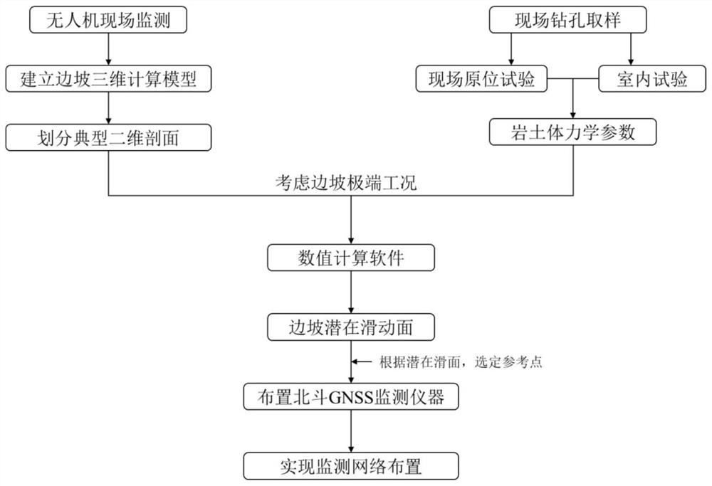
[0030] Use unmanned aerial vehicle photography equipment to take oblique photography of the area where the slope is located, and combine the geological survey drilling data to establish a three-dimensional geological model of the area where the slope is located.

[0031] The second step is to divide the typical two-dimen...


PUM


Abstract

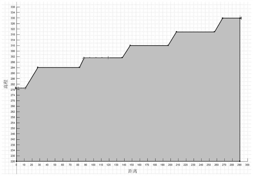
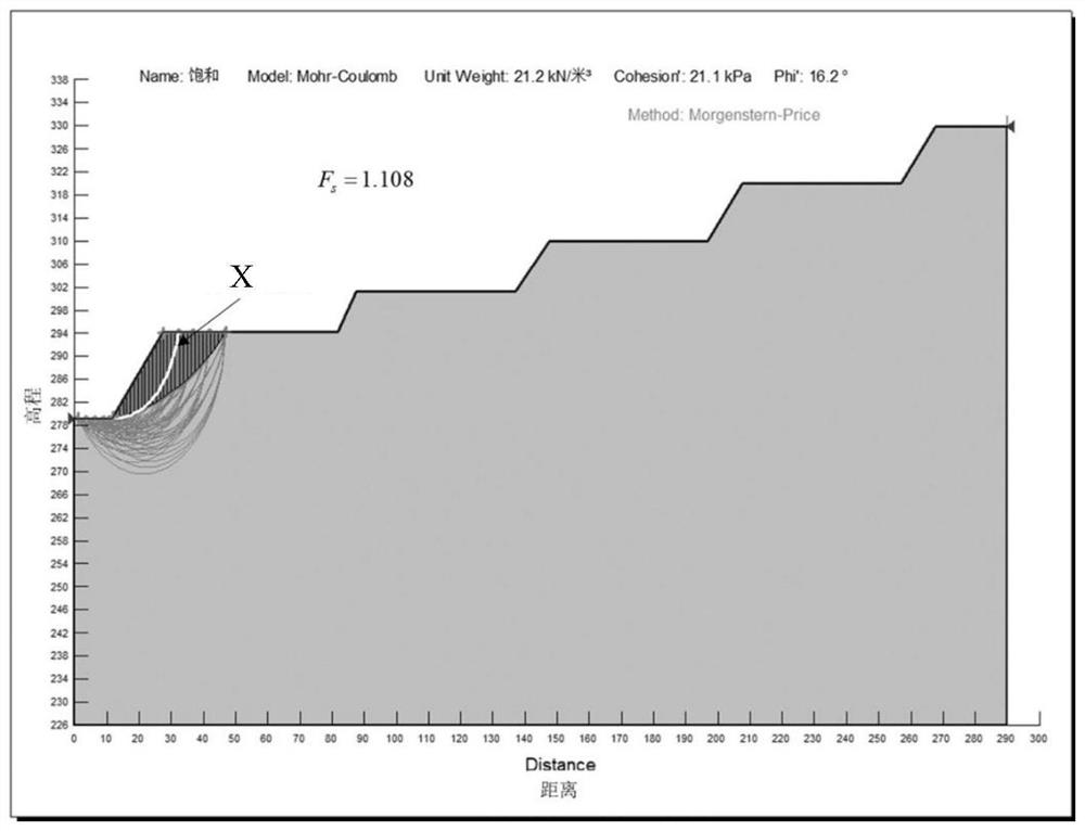
The invention discloses a method for laying out a Beidou GNSS monitoring system based on slope stability analysis, comprising: establishing a three-dimensional geological model of the slope through oblique photography and dividing a typical two-dimensional section to establish a two-dimensional analysis model; obtaining the rock and soil of the slope The physical and mechanical parameters of the body; the numerical analysis method is used to calculate the slope stability of the two-dimensional analysis model under extreme conditions, and the dangerous sliding surface is obtained; taking the obtained sliding surface as a reference, the leading edge of the landslide is cut and the trailing edge is pulled The fissure zone is projected to the corresponding position of the three-dimensional geological model to form a dangerous sliding surface projection line from the trailing edge to the leading edge of the landslide, and the Beidou GNSS monitoring instrument is arranged to form a monitoring area; different profile lines are selected, and the above steps are repeated. The Beidou GNSS monitoring instruments are deployed to form multiple monitoring areas. The present invention realizes the deployment of the monitoring network; realizes 360° no dead angle detection in the field, and has strong applicability; combines numerical simulation with engineering practice, and improves the monitoring work efficiency.

Description

technical field [0001] The invention relates to the technical field of geotechnical engineering, in particular to a method for laying out a Beidou GNSS monitoring system based on slope stability analysis. Background technique [0002] Slope stability is the first prerequisite for open-pit operations such as mining, and it is also an important topic of research in geotechnical engineering fields such as dam construction and roadbed engineering. The stability of the slope is not only affected by the mechanical strength of the rock and soil itself, but also includes extreme conditions such as heavy rain and earthquakes. Once the slope becomes unstable, it will cause unpredictable consequences. Therefore, it is of great engineering significance to accurately predict slope instability. [0003] At present, the most commonly used forecasting method is to deploy monitoring devices on the slope, and accurately predict the stability of the slope by monitoring the deformation of the ...

Claims


Application Information

Patent Timeline
Patent Type & Authority Patents(China)
IPC IPC(8): G01B15/06G01C11/36G06F30/20G06T17/05G06F111/10G06F119/14
CPCG01B15/06G01C11/00G06F30/20G06T17/05G06F2111/10G06F2119/14
Inventor 田宁付晓东陈健黄珏皓易顺
Owner INST OF ROCK & SOIL MECHANICS CHINESE ACAD OF SCI
Learn More