Method and system for automatic intersection recognition and its model preservation method and system

A technology for automatic identification of intersections, applied to roads, roads, image analysis, etc., can solve problems such as complex work and low efficiency, and achieve high recognition efficiency and high segmentation efficiency

Active Publication Date: 2021-10-29
BEIJING INSTITUTE OF TECHNOLOGYGY +1
View PDF10 Cites 3 Cited by
  • Summary
  • Abstract
  • Description
  • Claims
  • Application Information

AI Technical Summary

Problems solved by technology

[0002] At present, when making an intersection map, it is necessary to manually identify the location and type of the intersection, and artificially segment and obtain the intersection model and save it. The work is complicated and the efficiency is low.

Method used


Image

  • Method and system for automatic intersection recognition and its model preservation method and system
  • Method and system for automatic intersection recognition and its model preservation method and system
  • Method and system for automatic intersection recognition and its model preservation method and system

Examples


Embodiment 1

[0048] At present, there is no method for automatic identification of intersections based on unmanned vehicles. However, there are existing methods for identifying the types of fork road intersections based on unmanned vehicles. The method used to identify the types of fork road intersections is: to obtain the traversable distances of unmanned vehicles at various angles in the horizontal direction, and generate the angle- The histogram defined by the passable distance is used to obtain the beam model, and then the real-time identification and classification of fork road intersections are performed based on the beam model. However, most of the fork road intersection type identification methods use the fixed origin of the vehicle body coordinate system as the reference point for constructing the beam model when constructing the beam model. The point of the distance is used as the reference point for the construction of the beam model. Since the reference points for the construct...

Embodiment 2

[0070] This embodiment is used to provide an automatic identification system for intersections, such as Figure 7 As shown, the identification system includes:

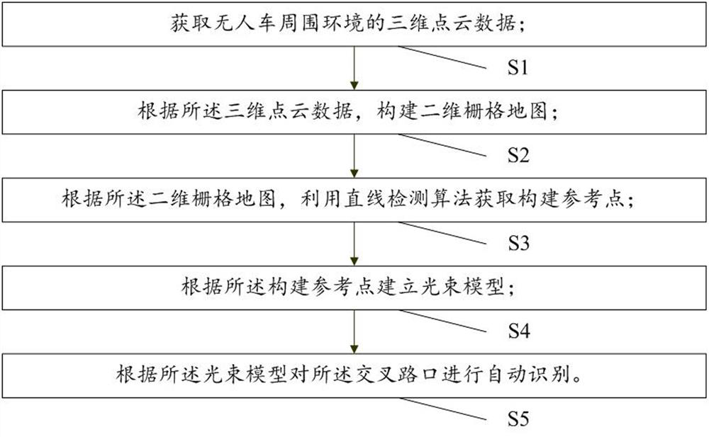
[0071] The first acquisition module M1 is used to acquire the three-dimensional point cloud data of the surrounding environment of the unmanned vehicle; the unmanned vehicle is located in the intersection;

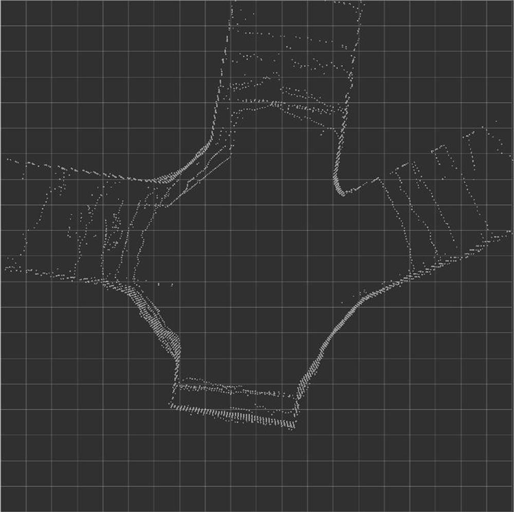
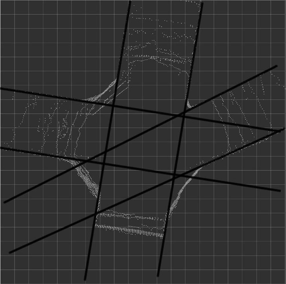
[0072] The first construction module M2 is configured to construct a two-dimensional grid map according to the three-dimensional point cloud data;

[0073] The construction reference point determination module M3 is used to obtain the construction reference point by using a straight line detection algorithm according to the two-dimensional grid map;

[0074] Building module M4, used for building beam model according to said building reference point;

[0075] The identification module M5 is configured to automatically identify the intersection according to the light beam model.

Embodiment 3

[0077] This embodiment is used to provide a method for saving an intersection model, such as Figure 8 As shown, the preservation method includes:

[0078] T1: Obtain 3D point cloud data of the surrounding environment of the unmanned vehicle; construct a 2D grid map according to the 3D point cloud data; use a straight line detection algorithm to obtain construction reference points according to the 2D grid map; People and vehicles are in the intersection;

[0079] Specifically, the specific method of this step is the same as the methods of S1, S2, and S3 in Embodiment 1, and will not be repeated here.

[0080] T2: According to the 3D point cloud data, use the LeGO-LOAM algorithm to construct a global map model;

[0081] The Lego-Loam algorithm is an open source SLAM (Synchronous Mapping and Localization) algorithm. Of course, in this embodiment, other SLAM algorithms may also be used when constructing the global map model, and there is no limitation on this.

[0082] T3: U...


PUM


Abstract

The invention relates to a method and system for automatic identification of intersections. A straight line detection algorithm is used to obtain construction reference points to establish a beam model, and finally the intersection is automatically identified according to the beam model, thereby eliminating the need for manual identification of the intersection and realizing the identification of the intersection. Automatic identification, high identification efficiency. The present invention also relates to a method and system for saving an intersection model, using the LeGO-LOAM algorithm to construct a global map model, to construct the position of the reference point in the global map model as the center of the intersection, to construct the reference point and two-dimensional point cloud data The distance between the road bending points farthest from the construction reference point is used as the minimum segmentation radius. Finally, the global map model is segmented according to the intersection center and the minimum segmentation radius to obtain the intersection model, and the intersection model is saved. Furthermore, without artificial segmentation, automatic segmentation and storage of the intersection model can be realized, and the segmentation efficiency is high.

Description

technical field [0001] The invention relates to the technical field of intersection map making, in particular to an intersection automatic recognition method and system and a model preservation method and system thereof. Background technique [0002] Currently, when making an intersection map, it is necessary to manually identify information such as the location and type of the intersection, and manually segment and obtain the intersection model and save it. The work is complicated and the efficiency is low. [0003] Based on this, there is an urgent need for a method capable of automatic identification of intersections and automatic preservation of intersection models. Contents of the invention [0004] The purpose of the present invention is to provide a method and system for automatic identification of intersections and its model preservation method and system, capable of automatic identification of intersections and automatic preservation of intersection models. [00...

Claims


Application Information

Patent Timeline
Patent Type & Authority Patents(China)
IPC IPC(8): G06T3/00G06T7/10E01C1/00
CPCE01C1/00G06T3/0031G06T2207/10028G06T7/10
Inventor 张旭东刘仕杰邹渊李圆圆孙逢春
Owner BEIJING INSTITUTE OF TECHNOLOGYGY
Why Eureka
Try Eureka