GNSS and V-SLAM fusion positioning method and system

A technology that integrates positioning and positioning results, applied in the field of navigation and positioning, can solve problems such as GNSS availability, reliability, continuity, and accuracy impact

Active Publication Date: 2021-09-24
NAT TIME SERVICE CENT CHINESE ACAD OF SCI
View PDF2 Cites 1 Cited by
  • Summary
  • Abstract
  • Description
  • Claims
  • Application Information

AI Technical Summary

Problems solved by technology

[0002] The Global Navigation Satellite System (GNSS) can achieve continuous high-precision navigation and positioning functions in an open environment, but in the environment of occlusion, interference and deception, the availability, reliability, continuity and accuracy of GNSS will be seriously affected. influences

Method used


Image

  • GNSS and V-SLAM fusion positioning method and system
  • GNSS and V-SLAM fusion positioning method and system
  • GNSS and V-SLAM fusion positioning method and system

Examples


Embodiment Construction

[0077] The following will clearly and completely describe the technical solutions in the embodiments of the present invention with reference to the accompanying drawings in the embodiments of the present invention. Obviously, the described embodiments are only some, not all, embodiments of the present invention. Based on the embodiments of the present invention, all other embodiments obtained by persons of ordinary skill in the art without making creative efforts belong to the protection scope of the present invention.

[0078] In order to make the above objects, features and advantages of the present invention more comprehensible, the present invention will be further described in detail below in conjunction with the accompanying drawings and specific embodiments.

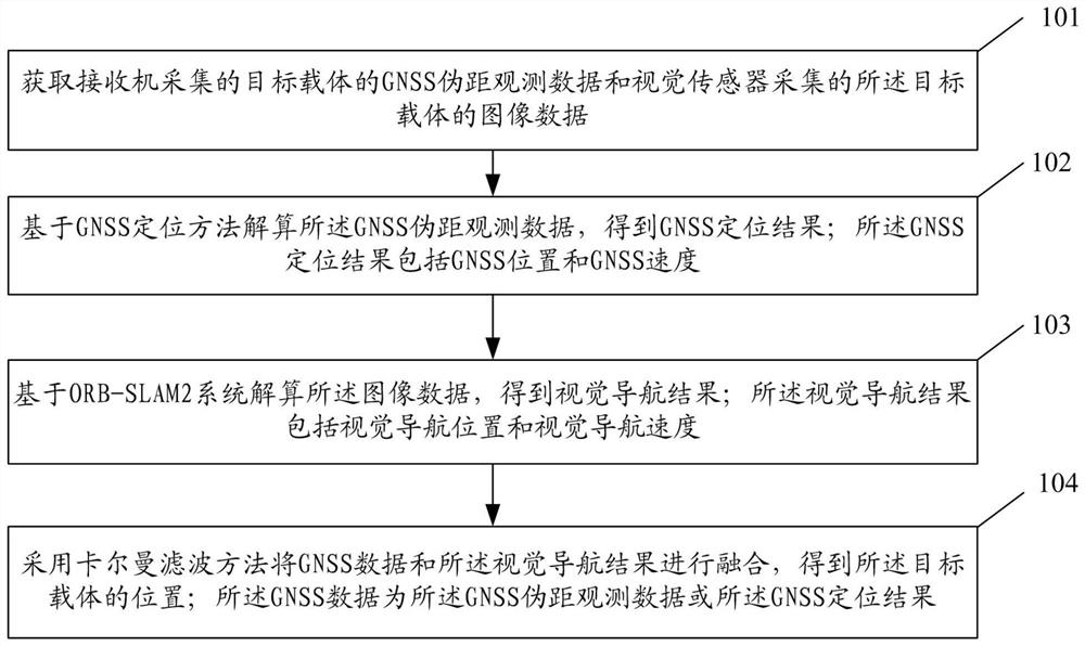
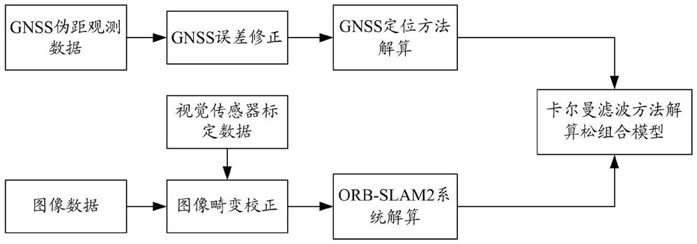
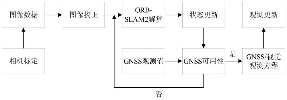
[0079] In order to ensure the continuity of navigation and positioning functions, the method of integrating GNSS and other navigation methods is often used for navigation and positioning. Visual Simultaneous Local...


PUM


Abstract

The invention discloses a GNSS and V-SLAM fusion positioning method and system. The method comprises steps of GNSS pseudo-range observation data, collected by a receiver, of a target carrier and image data, collected by a visual sensor, of the target carrier being acquired; calculating GNSS pseudo-range observation data based on a GNSS positioning method to obtain a GNSS positioning result; calculating the image data based on an ORB-SLAM2 system to obtain a visual navigation result; and fusing the GNSS pseudo-range or the GNSS positioning result with the visual navigation result by adopting a Kalman filtering method to obtain the position of the target carrier. According to the method, high-precision and continuous navigation positioning in a severe environment can be realized.

Description

technical field [0001] The invention relates to the field of navigation and positioning, in particular to a GNSS and V-SLAM fusion positioning method and system. Background technique [0002] The Global Navigation Satellite System (GNSS) can achieve continuous high-precision navigation and positioning functions in an open environment, but in the environment of occlusion, interference and deception, the availability, reliability, continuity and accuracy of GNSS will be seriously affected. Influence. Therefore, how to solve the problem that the accuracy and continuity of GNSS navigation positioning are seriously affected in a weak GNSS environment has become an urgent problem to be solved. Contents of the invention [0003] Based on this, an embodiment of the present invention provides a GNSS and V-SLAM fusion positioning method and system to achieve high-precision, continuous navigation and positioning in harsh environments. [0004] To achieve the above object, the prese...

Claims


Application Information

Patent Timeline
Patent Type & Authority Applications(China)
IPC IPC(8): G01S19/48G01C21/00
CPCG01S19/485G01C21/005Y02T10/40
Inventor 涂锐冯祎卢晓春韩军强张鹏飞王思遥张睿范丽红洪菊
Owner NAT TIME SERVICE CENT CHINESE ACAD OF SCI
Why Eureka
Try Eureka