SWAT-based gray water footprint calculation method for cotton
A calculation method and gray water technology, applied in design optimization/simulation, special data processing applications, etc., can solve problems such as low accuracy, rough calculation results, and difficulty in obtaining detailed data, and achieve the effect of improving calculation accuracy
- Summary
- Abstract
- Description
- Claims
- Application Information
AI Technical Summary
Problems solved by technology
Method used
Image
Examples
Embodiment 1
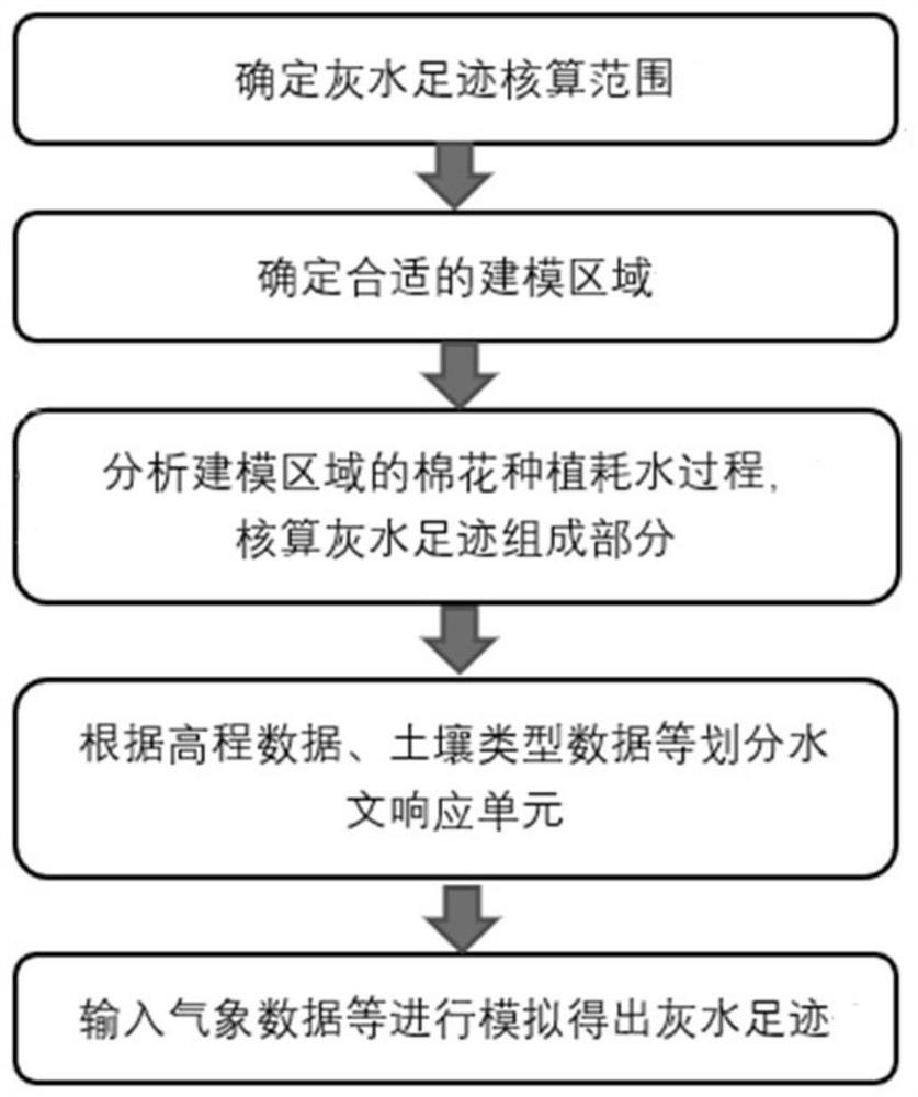
[0030] According to the gray water footprint calculation method of cotton based on SWAT of the present invention, take the cotton area of Yuli County, southern Xinjiang, as an example, calculate the cotton crop gray water footprint in TN, and the specific steps are as follows:
[0031] Step 1. Determine the scope of gray water footprint calculation in Yuli County, South Xinjiang by consulting the cotton planting distribution data in Yuli County, South Xinjiang;
[0032] Step 2, determine the appropriate modeling area within the scope of gray water footprint accounting;
[0033] Step 3: Analyze the water consumption process of cotton planting in the modeling area, including climate environment, soil, planting operations, etc., and calculate the gray water footprint components;
[0034] Step 4. According to the gray water footprint components, collect elevation data, soil type data, land use data, local meteorological and hydrological data, farmland management operation data, ...
Embodiment 2
[0038] According to the gray water footprint calculation method of cotton based on SWAT of the present invention, take the cotton area of Yuli County, southern Xinjiang, as an example, calculate the cotton crop gray water footprint in TP, and the specific steps are as follows:
[0039] Step 1. Determine the scope of gray water footprint calculation in Yuli County, South Xinjiang by consulting the cotton planting distribution data in Yuli County, South Xinjiang;
[0040] Step 2, determine the appropriate modeling area within the scope of gray water footprint accounting;
[0041] Step 3: Analyze the water consumption process of cotton planting in the modeling area, including climate environment, soil, planting operations, etc., and calculate the gray water footprint components;
[0042] Step 4. According to the gray water footprint components, collect elevation data, soil type data, land use data, local meteorological and hydrological data, farmland management operation data, et...
Embodiment 3
[0046] According to the gray water footprint calculation method of cotton based on SWAT of the present invention, take the cotton area of Yuli County, southern Xinjiang, as an example, calculate the gray water footprint of cotton crops in COD, and the specific steps are as follows:
[0047] Step 1. Determine the scope of gray water footprint calculation in Yuli County, South Xinjiang by consulting the cotton planting distribution data in Yuli County, South Xinjiang;
[0048] Step 2, determine the appropriate modeling area within the scope of gray water footprint accounting;
[0049] Step 3: Analyze the water consumption process of cotton planting in the modeling area, including climate environment, soil, planting operations, etc., and calculate the gray water footprint components;
[0050] Step 4. According to the gray water footprint components, collect elevation data, soil type data, land use data, local meteorological and hydrological data, farmland management operation d...
PUM
 Abstract
Description
Claims
Application Information
 - R&D
- Intellectual Property
- Life Sciences
- Materials
- Tech Scout
- Unparalleled Data Quality
- Higher Quality Content
- 60% Fewer Hallucinations
Browse by: Latest US Patents, China's latest patents, Technical Efficacy Thesaurus, Application Domain, Technology Topic, Popular Technical Reports.
© 2025 PatSnap. All rights reserved.Legal|Privacy policy|Modern Slavery Act Transparency Statement|Sitemap|About US| Contact US: help@patsnap.com


