Driving assistance system based on electronic map for open pit coal mine vehicle and early warning method

A driving assistance system, open-pit coal mine technology, applied in transmission systems, control/regulation systems, motor vehicles, etc., can solve problems such as signal delay and blockage

Pending Publication Date: 2021-11-02
内蒙古白音华蒙东露天煤业有限公司 +1
View PDF0 Cites 0 Cited by
  • Summary
  • Abstract
  • Description
  • Claims
  • Application Information

AI Technical Summary

Problems solved by technology

[0006] In view of the above-mentioned technical deficiencies, the purpose of the present invention is to provide a driving assistance system for open-pit coal mine vehicles, to solve the problem of signal delay or blockage in the network transmission process, and to monitor production and mining equipment, transportation equipment, and on-site management vehicles in real time And optimize management, obtain vehicle location information, vehicle status information, alarm information and other content through the vehicle terminal, and perform visual expression and display on the front-end map platform

Method used


Image

  • Driving assistance system based on electronic map for open pit coal mine vehicle and early warning method
  • Driving assistance system based on electronic map for open pit coal mine vehicle and early warning method

Examples


Embodiment

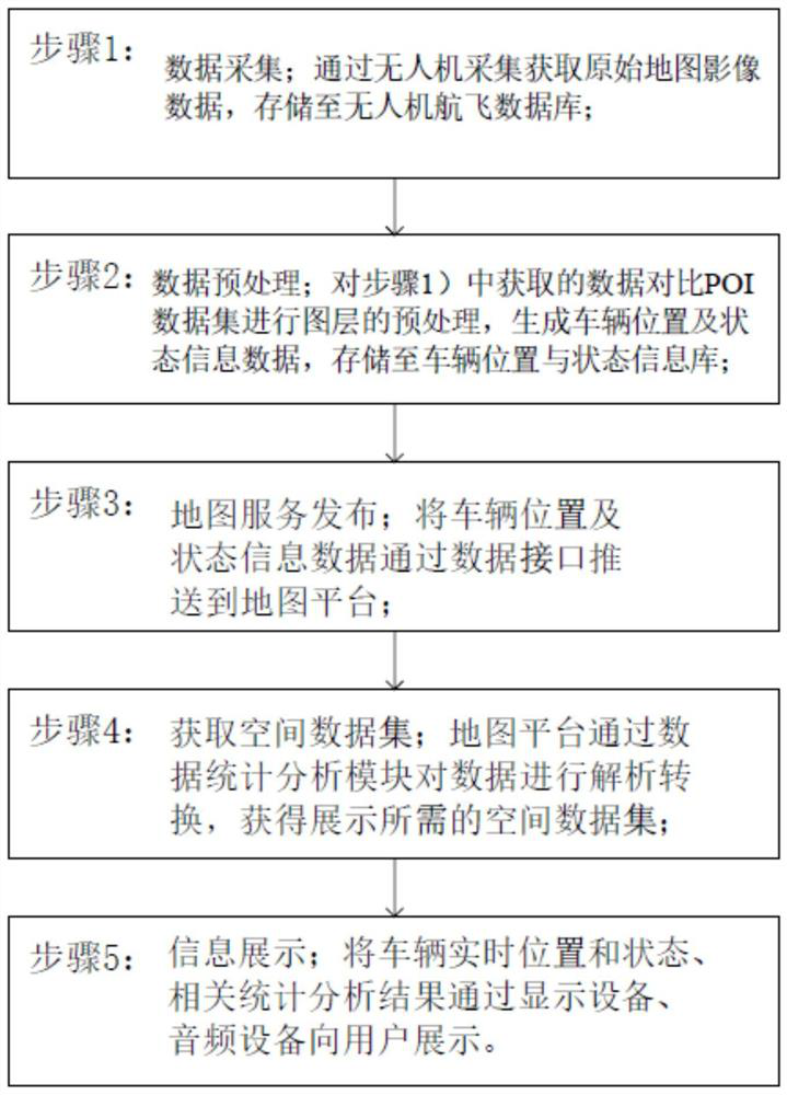
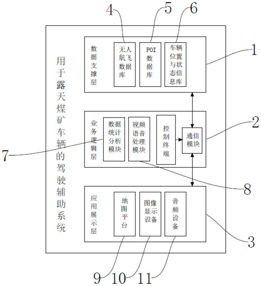
[0037] Such as figure 2 As shown, the present invention provides a driving assistance system for open-pit coal mine vehicles, including a data support layer 1, which provides basic data services and descriptions of other spatial positions and spatial relationships for the entire map platform 9; Integrate and analyze data sources, complete data analysis of functional subsystems of different protocols and standards, and organize and package data according to specified requirements; apply display layer 3, provide users with a visual display scene, and realize vehicles and personnel within the mining area , Visual supervision of equipment;

[0038] Wherein, the business logic layer 2 includes a control terminal 12 , and the control terminal 12 is wirelessly connected to the data support layer 1 and the application presentation layer 3 through a communication module 13 .

[0039] As a further optimization scheme of the embodiment of the present invention, the data support layer 1...


PUM


Abstract

The invention discloses a driving assistance system based on an electronic map for an open pit coal mine vehicle and an early warning method. The system comprises a data support layer for providing basic data service and description of other spatial positions and spatial relationships for the whole map platform; a business logic layer, which is used for integrating and analyzing each data source, completing data analysis work of functional subsystems with different protocols and standards, and organizing and packaging the data according to specified requirements; an application display layer, which is used for providing a visual display scene for a user and realizing visual supervision of vehicles, personnel and equipment in a mining area range. The problem of signal delay or blockage in the network transmission process is solved, production mining equipment, transportation equipment and field management vehicles are monitored and optimally managed in real time, and vehicle position information, vehicle state information, alarm information and other contents are obtained through the vehicle terminal and are visually expressed and displayed on the front-end map platform.

Description

technical field [0001] The invention relates to the technical field of driving assistance systems, in particular to an electronic map-based driving assistance system and an early warning method for open-pit coal mine vehicles. Background technique [0002] Coal mining can be divided into open-pit mining and underground mining. Since the production efficiency and safety performance of open-pit mining are significantly better than underground mining, with the support of policies, open-pit coal mines are characterized by large-scale and intensive mining, which leads to The number of equipment in the mine has increased significantly. With the continuous promotion and application of digital mine technology and the continuous improvement of mine safety management informatization level, some large open-pit coal mines have invested in truck anti-collision warning systems. [0003] Existing driving assistance systems for open-pit coal mine vehicles have the following deficiencies: ...

Claims


Application Information

Patent Timeline
IPC IPC(8): G05D1/02H04L29/08
CPCG05D1/0214G05D1/0276H04L67/12
Inventor 郭苏煜于亚波孙中飞王吉洋刘建彬孙亚娟刘刚朱勇刘通
Owner 内蒙古白音华蒙东露天煤业有限公司
Why Eureka
Try Eureka