Urban regional traffic big data analysis system based on positioning system

A positioning system and urban area technology, applied in the field of urban area traffic big data analysis system, can solve the problems of data misreporting and single data source, and achieve the effects of reducing misreporting, ensuring objectivity, and reducing complexity

Active Publication Date: 2021-11-02
广州时空位置网科学技术研究院有限公司
View PDF7 Cites 0 Cited by
  • Summary
  • Abstract
  • Description
  • Claims
  • Application Information

AI Technical Summary

Problems solved by technology

[0007] The present invention provides an urban regional traffic big data analysis system based on a positioning system to solve the problem of a single data source and false positives in some data

Method used


Image

  • Urban regional traffic big data analysis system based on positioning system

Examples


Embodiment 1

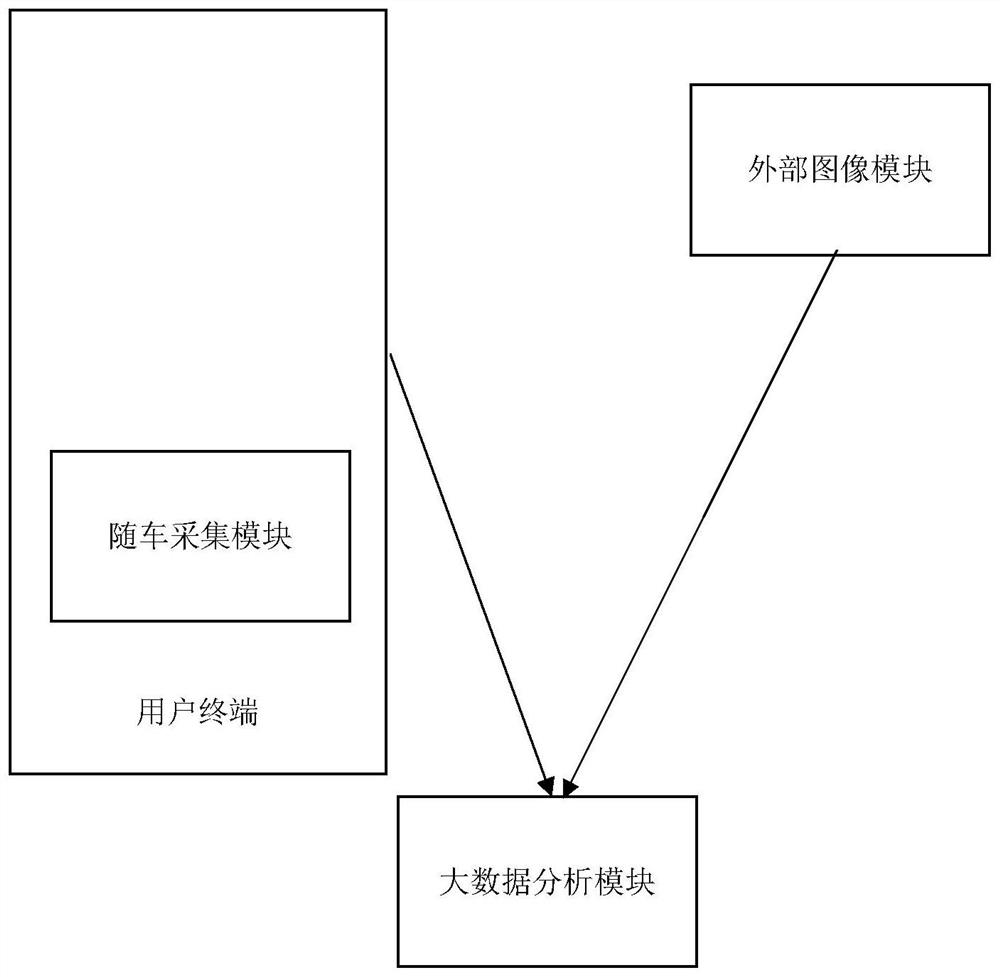
[0028] A kind of urban regional traffic big data analysis system based on the positioning system of the present embodiment (such as figure 1 shown), including: user terminal (the user terminal is a smart phone or a vehicle-mounted host, the smart phone selected in this embodiment); also includes:

[0029] The positioning system is relatively fixed with the user terminal, and is used to collect the user's first positioning information and send it to the user terminal. The user terminal obtains the user's vehicle driving direction, travel speed, acceleration (acceleration of the vehicle) according to the change rate of the first positioning information. It can also be collected through the acceleration sensor that comes with the smart phone);

[0030] The external image module, placed at a specific intersection, is used to collect vehicle driving images, and obtain the external feature information, travel speed and acceleration of the vehicle according to the vehicle images;

...


PUM


Abstract

The invention relates to the technical field of traffic data processing, in particular to an urban regional traffic big data analysis system based on a positioning system. The system comprises: a positioning system which is fixed relative to the position of the user terminal, is used for collecting first positioning information of a user and sending the first positioning information to the user terminal, is arranged at a specific intersection and is used for collecting a vehicle driving image; a vehicle-mounted acquisition module which is fixed relative to the position of the user terminal and is used for acquiring a first environment image in the vehicle driving process when the acceleration of the positioning system exceeds a threshold value; and a big data analysis module which is used for reading the first positioning information corresponding to the first environment image and judging whether the first environment image is associated with the vehicle driving image or not according to the travel speed and the acceleration. By adopting the technical scheme of the invention, the problems of single data source and misinformation of partial data can be solved.

Description

technical field [0001] The invention relates to the technical field of traffic data processing, in particular to a positioning system-based urban regional traffic big data analysis system. Background technique [0002] With the development of urbanization, the problem of urban traffic congestion has become prominent, seriously affecting the operation of the city and the development of the economy. Comprehensive and effective acquisition of real-time dynamic traffic information on roads, processing and analyzing the information, quickly and accurately determining the state of traffic flow in the road network, helps to detect traffic congestion in time, and formulates reasonable and effective traffic congestion relief strategies, which can greatly reduce traffic congestion. The scope of influence of congestion, reducing the harm of congestion in terms of time, economy and environment, can also avoid road network traffic paralysis caused by local traffic congestion. [0003] U...

Claims


Application Information

Patent Timeline
Patent Type & Authority Applications(China)
IPC IPC(8): G08G1/01G08G1/065G08G1/052G08G1/056G08G1/017H04W4/02G01S19/42
CPCG08G1/0125G08G1/0137G08G1/065G08G1/052G08G1/056G08G1/017G08G1/0175H04W4/027G01S19/42
Inventor 王韬景贵飞曹红杰
Owner 广州时空位置网科学技术研究院有限公司
Why Eureka
Try Eureka