SPOT-6 satellite image direct geographic positioning method based on FPGA hardware

A SPOT-6, satellite image technology, applied in the field of satellite remote sensing image processing, can solve the problem of insufficient number of gate circuits of editable devices, and achieve the effect of meeting timeliness

Pending Publication Date: 2021-11-19
NANJING UNIV OF TECH
View PDF2 Cites 2 Cited by
  • Summary
  • Abstract
  • Description
  • Claims
  • Application Information

AI Technical Summary

Problems solved by technology

FPGA not only solves the shortcomings of custom circuits, but also overcomes the shortcomings of the original editable device gates.

Method used


Image

  • SPOT-6 satellite image direct geographic positioning method based on FPGA hardware
  • SPOT-6 satellite image direct geographic positioning method based on FPGA hardware
  • SPOT-6 satellite image direct geographic positioning method based on FPGA hardware

Examples


Embodiment Construction

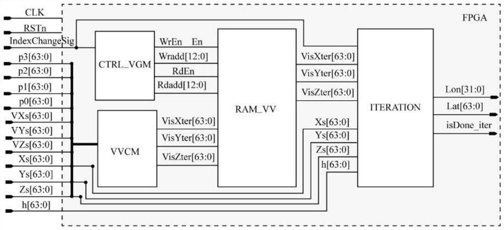
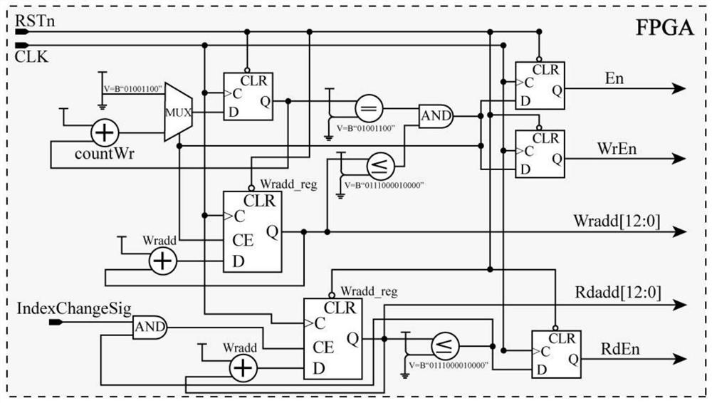
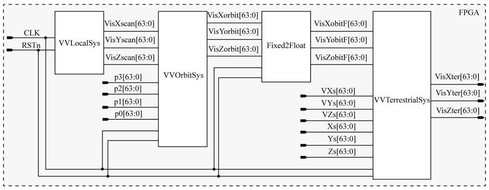
[0024] The FPGA hardware-based SPOT-6 satellite image direct geolocation method of the present invention will be described in detail below in conjunction with the embodiments and accompanying drawings.

[0025] The direct geolocation method of the SPOT-6 satellite image based on FPGA hardware of the present invention comprises the steps:

[0026] 1) Calculate the line-of-sight vector u of the pixel in the body coordinate system 1 ;

[0027] It is calculated by the following formula, namely:

[0028]

[0029] Among them, the line of sight vector u 1 The components TanPsiX and TanPsiY are calculated by the following formulas respectively:

[0030]

[0031]

[0032] In the formula, is the polynomial coefficient; i=1,2,3,...,N, i is the column number of the pixel in the scanning row; i ref =1 is the column number of the reference pixel in the scanning line; N is the number of detection elements; VisXscan, VisYscan and VisZscan are the line of sight vector u 1 of 3 ...


PUM


Abstract

The invention discloses an SPOT-6 satellite image direct geographic positioning method based on FPGA hardware. The SPOT-6 satellite image direct geographic positioning method comprises the following steps: calculating a sight line vector u1 of a pixel in a body coordinate system; calculating a sight line vector u2 of the pixel in the orbital coordinate system according to the sight line vector u1; calculating a sight line vector u3 of the pixel in the geocentric coordinate system according to the sight line vector u2; and calculating the geodetic coordinate [L, B, h'] T of the ground point according to the sight line vector u3. According to the SPOT-6 satellite image direct geographic positioning method based on the FPGA hardware, the FPGA is used as a hardware acceleration platform, a Verilog hardware language is used as a design language, under the condition of limited hardware resources, an uncontrolled positioning optimization algorithm of a satellite image is achieved, namely, a remote sensing image direct geographic positioning method based on a VGM (Viewing Geometry Model) is achieved, and the requirements of timeliness, portability and miniaturization of satellite image positioning in the satellite remote sensing field are met.

Description

technical field [0001] The invention relates to a satellite remote sensing image processing method. In particular, it relates to a direct geolocation method of SPOT-6 satellite images based on FPGA hardware. Background technique [0002] Using satellite images to locate ground targets has become an important research field in remote sensing, digital photogrammetry, and geographic information systems. The key technical index to measure the mapping capability of high-resolution satellite imagery is the accuracy of direct positioning of the target by the image without Ground Control Points (GCPs) or with few GCPs. In addition, the direct geolocation technology of satellite images can provide the ground range covered by orthophotos for real-time orthorectification of on-board images. Therefore, it is necessary to study the real-time direct geolocation technology of satellite images. [0003] Studies have shown that one of the effective means of global surveying and mapping is...

Claims


Application Information

Patent Timeline
Patent Type & Authority Applications(China)
IPC IPC(8): G01S19/42
CPCG01S19/42
Inventor 张荣庭张广运周国清朱强
Owner NANJING UNIV OF TECH
Why Eureka
Try Eureka