Road damage disaster rapid evaluation system based on remote sensing cloud service platform and application thereof

A cloud service platform and evaluation system technology, which is applied in the field of rapid evaluation system for road damage and disasters, can solve problems such as backwardness, excessive human labor, and ground object information not being updated in time, and achieve the effect of reducing time

Pending Publication Date: 2021-12-17
应急管理部国家减灾中心 +1
View PDF0 Cites 0 Cited by
  • Summary
  • Abstract
  • Description
  • Claims
  • Application Information

AI Technical Summary

Problems solved by technology

Geographic Information System (GIS) data, topographic map data and other vector geographic data that have been collected and edited manually have the characteristics of high precision and strong reliability, but due to the need for more human labor, they often lag behind remote sensing data in terms of temporal Image, some changed features information has not been updated in time

Method used


Image

  • Road damage disaster rapid evaluation system based on remote sensing cloud service platform and application thereof
  • Road damage disaster rapid evaluation system based on remote sensing cloud service platform and application thereof
  • Road damage disaster rapid evaluation system based on remote sensing cloud service platform and application thereof

Examples


Embodiment

[0055] Embodiment A rapid assessment system for road damage and disaster based on remote sensing cloud service platform

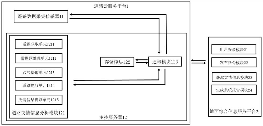
[0056] A remote sensing cloud service platform-based rapid road damage assessment system in this embodiment includes a remote sensing cloud service platform 1 and a ground comprehensive information service platform 2 .

[0057] The remote sensing cloud service platform 1 includes a remote sensing data acquisition sensor 11 and a main control server 12 .

[0058] Main control server 12 comprises road disaster information analysis module 121, storage module 122, communication module 123; Storage module 122 is respectively connected with road disaster information analysis module, remote sensing data acquisition sensor by communication module 123.

[0059] The ground comprehensive information service platform 2 is connected with the remote sensing cloud service platform 1 through the communication module 123 .

[0060] The road disaster information analysis mo...


PUM


Abstract

The invention discloses a road damage disaster rapid evaluation system based on a remote sensing cloud service platform and application thereof, the road damage disaster rapid evaluation system based on the remote sensing cloud service platform comprises the remote sensing cloud service platform, and the remote sensing cloud service platform comprises a master control server. A road disaster information analysis module is integrated on the master control server, and the road disaster information analysis module executes a remote sensing image preprocessing method, a disaster damaged road vector information extraction method or a disaster damaged road disaster extraction method based on vector guidance. According to the invention, related algorithms such as data processing, geological disaster extraction and disaster assessment are integrated in the remote sensing cloud service platform comprising the sensor, so that the disaster assessment time is shortened. The data can be quickly and directly transmitted to emergency disaster reduction users, the quick acquisition requirement of the users is met, and the event response time is improved from the hour level to the minute level.

Description

technical field [0001] The invention belongs to the field of information science and technology, and relates to a remote sensing cloud service platform-based rapid assessment system for road damage and disaster situation and its application. Background technique [0002] With the rapid development of aerospace and remote sensing technology, the ability of remote sensing to observe the earth has been continuously improved, presenting three-multiple (multi-platform, multi-sensor, multi-angle) and three-high (high spectral resolution, high temporal resolution, high spatial resolution) )specialty. The spatial resolution of images acquired by advanced satellite systems can reach meter or sub-meter level, and the revisit cycle only takes a few days or even hours, which can meet the application requirements of different levels from coarse to fine, and provide a basis for the acquisition and application of surface information. Sufficient data sources are provided. However, how to ...

Claims


Application Information

Patent Timeline
IPC IPC(8): G06K9/00G06K9/34G06K9/36G06K9/46G06K9/62
CPCG06F18/22G06F18/23213
Inventor 王志强张晓冉柳锦宝麻楠楠阿多刘乃山
Owner 应急管理部国家减灾中心
Why Eureka
Try Eureka