Unmanned ship self-adaptive step length path searching method based on terrain complexity

An adaptive step size, path search technology, applied in two-dimensional position/course control, vehicle position/route/altitude control, instruments and other directions, which can solve the problem of unoptimized paths, path neglect, path search step size, etc. problems, to achieve the effect of improving the path quality, shortening the path length, and reducing the amount of calculation

Active Publication Date: 2021-12-31
ZHEJIANG UNIV
View PDF7 Cites 0 Cited by
  • Summary
  • Abstract
  • Description
  • Claims
  • Application Information

AI Technical Summary

Problems solved by technology

[0005] In summary, the path planning in the prior art has at least the following defects: in some cases, the step size of the path search is too large, causing some possible paths to be ignored; in some cases, the step size of the path search is too small, resulting in There are too many grids on the map, which will cause unnecessary increase in the calculation amount of the algorithm and the required running memory, thereby increasing the time required for the algorithm and the memory consumption; the obtained path is not optimized, and the quality of the path is not good. Sharp inflection points, unnecessary detours, and a large gap with the optimal traffic path

Method used


Image

  • Unmanned ship self-adaptive step length path searching method based on terrain complexity
  • Unmanned ship self-adaptive step length path searching method based on terrain complexity
  • Unmanned ship self-adaptive step length path searching method based on terrain complexity

Examples


Embodiment Construction

[0027] The present invention will be described in further detail below in conjunction with the accompanying drawings and specific embodiments.

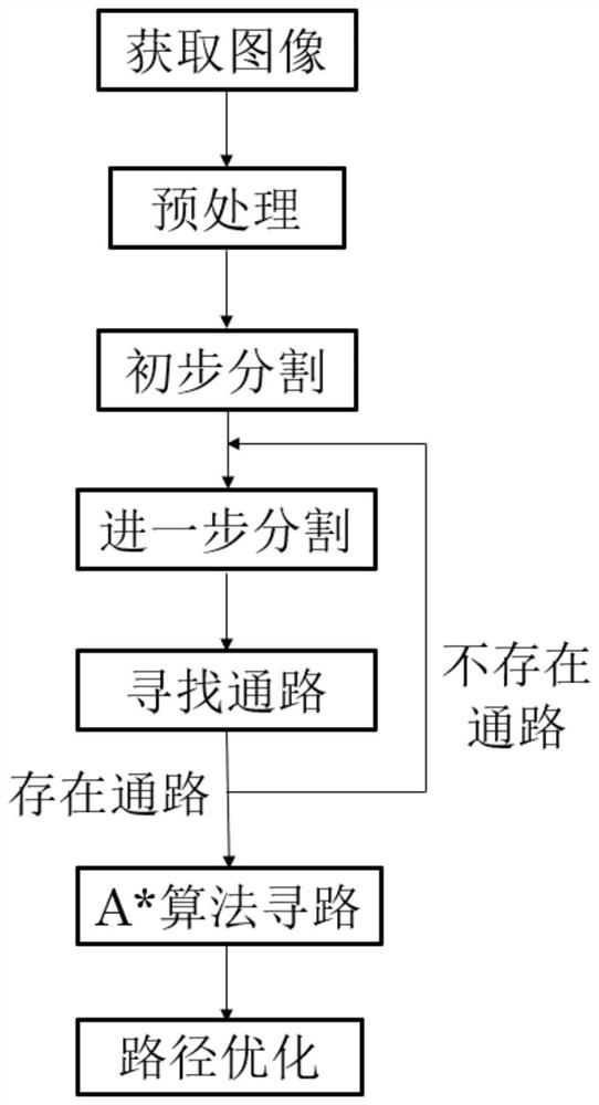
[0028] Such as figure 1 As shown, the method includes the following steps:

[0029] Step 100, obtain electronic nautical charts and satellite images, and superimpose the electronic nautical charts and satellite images correspondingly to obtain environmental static images; taking into account the water level changes brought about by the ebb and flow of tides, taking the 10m water depth as a benchmark, the land area in the environmental static images The area with a water depth less than 10m is marked as an obstacle area, and the area with a water depth greater than 10m is marked as a passable area, so as to binarize the static image of the environment;

[0030] In step 200, the obstacle area is marked as the highlighted area, and the dilation operation is performed on the binarized preprocessed environmental static image, so that the ...


PUM


Abstract

The invention discloses an unmanned ship self-adaptive step length path searching method based on terrain complexity. The method comprises the following steps: acquiring an environment static image and carrying out binarization preprocessing; carrying out image expansion and rasterization to establish a map environment model; carrying out terrain complexity calculation and screening reduction on each grid; searching an optimal passing path in the map environment model by using an A* algorithm; and further optimizing the obtained optimal passing path to obtain a final optimized path. According to the method, the terrain complexity is calculated according to the map environment model, the map can be autonomously segmented for analysis and processing, calculation of a complete obstacle area is omitted, the calculation amount and the required running memory are reduced, the path is optimized, many unnecessary inflection points are reduced, the overall path length is shortened, and the path quality is improved.

Description

technical field [0001] The invention relates to an artificial intelligence-based path planning method for an unmanned ship, in particular to autonomous path planning and path optimization for an unmanned ship, specifically an adaptive step-length path search method for an unmanned ship based on terrain complexity. Background technique [0002] With the continuous development of technology in the field of marine monitoring in my country, the demand for automatic pathfinding algorithms for unmanned ships is becoming more and more extensive. Through unmanned ships with automatic navigation and pathfinding functions, people can achieve more frequent and more comprehensive maritime monitoring, and better complete surveys, sampling, rescue, etc. [0003] For example, the invention patent with application number CN 111930121 A proposes a mixed path planning method for indoor mobile robots, using the grid method to model the space where the robot is located, and using the bat algori...

Claims


Application Information

Patent Timeline
Patent Type & Authority Applications(China)
IPC IPC(8): G05D1/02
CPCG05D1/0206
Inventor 李贞辉张敏捷吕小文孙向伟聂勇唐建中陈正
Owner ZHEJIANG UNIV
Why Eureka
Try Eureka