Mass point cloud layered real-time rendering method based on octree index

A real-time rendering and point cloud technology, applied in the field of 3D laser scanning data processing, can solve the problems of data redundancy, empty packets and memory waste, uneven point cloud data, etc., to avoid data redundancy, reduce memory consumption, improve The effect of index query efficiency

Pending Publication Date: 2021-12-31
CHINA RAILWAY FIRST SURVEY & DESIGN INST GRP
View PDF3 Cites 4 Cited by
  • Summary
  • Abstract
  • Description
  • Claims
  • Application Information

AI Technical Summary

Problems solved by technology

[0002] At present, 3D laser scanning technology can be used in digital protection of cultural relics, civil engineering, industrial measurement, natural disaster investigation, digital city terrain visualization, urban and rural planning and other fields. The data volume often reaches GB or even TB level, while the commonly used computer memory is only 4-16GB , the point cloud data cannot be loaded at one time, and massive point clouds need to be managed and scheduled
At present, KD tree, R tree, quadtree, octree, etc. are commonly used, and combined with the pyramid structure to build indexes for point clouds, and the quality of index construction directly affects the organization and query efficiency of point cloud data. If point clouds cannot Real-time refresh cannot meet the needs of massive point cloud visualization
[0003] Patent CN104750854B discloses a massive 3D laser point cloud compression storage and fast loading display method. By collecting the overall structure of point cloud data, the data is classified and compressed according to different levels. Each level includes block sets, blocks and packages. Three-level index , to achieve a high degree of storage and fast loading display, but it does not consider the data size of the point cloud file and the characteristics of the sparse distribution of the point cloud when dividing the point cloud, which will cause a lot of empty packets and memory waste, etc.
[0004] Patents CN106407408B, CN105808672, etc. disclose a method and device for constructing a spatial index of massive point cloud data. The obtained original point cloud data is divided into blocks to obtain multiple point cloud data blocks; for each point cloud data block, construct the current The octree index of the point cloud data block; the octree index of multiple point cloud data blocks is merged to obtain the spatial index structure of the original point cloud data, but in the process of establishing the point cloud octree pyramid structure, There is an intersection between different layers, resulting in data redundancy; and it uses a random sampling method, resulting in uneven point cloud data

Method used


Image

  • Mass point cloud layered real-time rendering method based on octree index
  • Mass point cloud layered real-time rendering method based on octree index
  • Mass point cloud layered real-time rendering method based on octree index

Examples


Embodiment Construction

[0072] The present invention will be described in detail below in combination with specific embodiments.

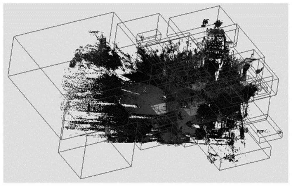
[0073] Present embodiment is based on las point cloud file, and its file size is 28GB, altogether 1.1 billion points; figure 1 Shown in the general flowchart of the present invention, the present invention comprises the following steps:

[0074] Step 1: Point cloud 3D grid segmentation

[0075] 1) According to the coordinate range and the number of point clouds recorded in the point cloud file header, define the side length of the three-dimensional space grid unit, and the grid side length is 256; according to the side length of the three-dimensional space grid unit, define the three-dimensional grid linear coding array grid[256*256*256];

[0076] 2) Fixedly read one million points in the point cloud file, access the point coordinates of the one million points according to the address link of the data, and define a thread pool, and use a multi-thread mechanism to dynami...


PUM


Abstract

The invention discloses a massive point cloud layered real-time rendering method based on an octree index. The three-dimensional laser scanning data volume often reaches a GB level or even a TB level, and if point clouds cannot be refreshed in real time, the requirement for visualization of massive point clouds cannot be met. The method comprises the six steps of point cloud three-dimensional grid partitioning, tiny point cloud block fusion in combination with octree features, point cloud partitioning binary system bin file dynamic output, point cloud partitioning binary system bin file multi-level index construction, Poisson disc uniform sampling, hierarchical structure output and point cloud real-time hierarchical scheduling rendering. According to the method, the point cloud file is subjected to three-dimensional grid partitioning, so that the memory consumption is greatly reduced, and the index query efficiency is improved; and an improved Poisson disk sampling strategy is used, so that data redundancy is avoided.

Description

technical field [0001] The invention belongs to the technical field of three-dimensional laser scanning data processing, and relates to a layered real-time rendering method of massive point clouds based on an octree index. Background technique [0002] At present, 3D laser scanning technology can be used in digital protection of cultural relics, civil engineering, industrial measurement, natural disaster investigation, digital urban terrain visualization, urban and rural planning and other fields. The data volume often reaches GB or even TB level, while the commonly used computer memory is only 4-16GB , the point cloud data cannot be loaded at one time, and massive point clouds need to be managed and scheduled. At present, KD tree, R tree, quadtree, octree, etc. are commonly used, and combined with the pyramid structure to build indexes for point clouds, and the quality of index construction directly affects the organization and query efficiency of point cloud data. If point...

Claims


Application Information

Patent Timeline
Patent Type & Authority Applications(China)
IPC IPC(8): G06T15/00
CPCG06T15/005G06T2200/04G06T2210/56
Inventor 张邵华杨秉岐武瑞宏田社权袁永信张占忠张卫龙杨远超何小飞田生辉
Owner CHINA RAILWAY FIRST SURVEY & DESIGN INST GRP
Why Eureka
Try Eureka