Rapid and high-precision GNSS landslide monitoring method, device and system

A monitoring system and high-precision technology, applied in the direction of measuring devices, radio wave measurement systems, satellite radio beacon positioning systems, etc., can solve the problems of inability to monitor in real time and slow calculation speed, so as to improve real-time monitoring and accuracy , Improve the effect of measurement accuracy

Pending Publication Date: 2022-01-04
SICHUAN YUANDE SECURITY DETECTION EQUIP CO LTD
View PDF0 Cites 2 Cited by
  • Summary
  • Abstract
  • Description
  • Claims
  • Application Information

AI Technical Summary

Problems solved by technology

[0003] In order to solve the problem that the existing signal has a slow calculation speed and cannot be monitored in real time when passing through the atmosphere and other interferences, the present invention provides a fast and high-precision GNSS landslide monitoring method, device and system, which can be realized without a 4G network Landslide monitoring, and can prevent satellite data from being affected by environmental factors such as ionospheric disturbance and tropospheric delay, and improve the accuracy of landslide data monitoring without 4G network

Method used


Image

  • Rapid and high-precision GNSS landslide monitoring method, device and system
  • Rapid and high-precision GNSS landslide monitoring method, device and system

Examples


Embodiment Construction

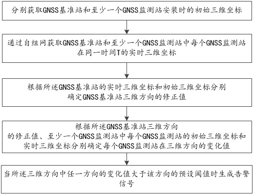
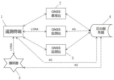
[0033] The present invention will be further elaborated below in conjunction with the accompanying drawings and specific embodiments. It should be noted here that although the descriptions of these embodiments are used to help the understanding of the present invention, they are not intended to limit the present invention. Specific structural and functional details disclosed herein are for purposes of describing example embodiments of the invention only. However, the invention may be embodied in many alternative forms and should not be construed as limited to the embodiments set forth herein.

[0034] It will be understood that, although the terms first, second etc. may be used herein to describe various elements, these elements should not be limited by these terms. These terms are only used to distinguish one unit from another. For example, a first element could be termed a second element, and, similarly, a second element could be termed a first element, without departing f...


PUM


Abstract

The invention discloses a rapid and high-precision GNSS landslide monitoring method, device and system. The method comprises the following steps: obtaining initial three-dimensional coordinates of a GNSS base station and a GNSS monitoring station during installation through an ad hoc network as adjustment values; obtaining real-time three-dimensional coordinates of each GNSS monitoring station in the GNSS base station and the GNSS monitoring stations at the same time T through an ad hoc network; according to the real-time three-dimensional coordinate and the initial three-dimensional coordinate of the GNSS base station, determining a correction value of the GNSS base station, and taking the correction value as a corresponding correction value of all the GNSS monitoring stations at the time T to obtain a change value of each GNSS monitoring station in the three-dimensional direction; and when the change value of any direction in the three-dimensional directions is greater than a preset threshold value of the direction, generating an alarm signal. By adopting the method, landslide monitoring can be realized without a 4G network, satellite data can be prevented from being influenced by environmental factors such as ionosphere disturbance and troposphere delay, and the precision of landslide data monitoring without the 4G network is improved.

Description

technical field [0001] The invention belongs to the technical field of landslide monitoring, and in particular relates to a fast and high-precision GNSS landslide monitoring method, device and system. Background technique [0002] GNSS (Global Satellite Positioning System) has been introduced into the monitoring of geological disasters as a high-tech in recent years. It has all-weather, fast positioning, high precision, automation, and measuring stations. The measuring station and the reference station do not need to be in sight. Therefore, it is also widely used in the monitoring of landslide deformation of geological disasters, bridges, reservoir dams, and dangerous buildings. For ground users, the influence of various complex environments needs to be considered comprehensively during the process from the space satellite transmitting signals to the user receiving signals. When the signal passes through the atmosphere, it will be affected by environmental factors such as io...

Claims


Application Information

Patent Timeline
Patent Type & Authority Applications(China)
IPC IPC(8): G01S19/42G01S19/12
CPCG01S19/42G01S19/12
Inventor 熊清远何龙江肖洋吴何熊娅伶石砚秋王毅何小强吕伟刘云腾
Owner SICHUAN YUANDE SECURITY DETECTION EQUIP CO LTD
Why Eureka
Try Eureka