Water depth inversion method based on satellite-borne single-photon laser active and passive remote sensing fusion

A water depth inversion, single-photon technology, applied in the re-radiation of electromagnetic waves, the use of re-radiation, measurement devices and other directions, can solve the problem of inability to obtain ground, ship or airborne measurement data.

Pending Publication Date: 2022-01-21
SECOND INST OF OCEANOGRAPHY MNR +1
View PDF0 Cites 2 Cited by
  • Summary
  • Abstract
  • Description
  • Claims
  • Application Information

AI Technical Summary

Problems solved by technology

Satellite bathymetry using traditional empirical modeling approaches to multispectral imaging, a process that typically relies on in situ measurements in situ as control point data, but ground, shipborne, or airborne measurements are not available in remote locations around the world

Method used


Image

  • Water depth inversion method based on satellite-borne single-photon laser active and passive remote sensing fusion
  • Water depth inversion method based on satellite-borne single-photon laser active and passive remote sensing fusion
  • Water depth inversion method based on satellite-borne single-photon laser active and passive remote sensing fusion

Examples


Embodiment Construction

[0036] The present invention will be described in detail below according to the accompanying drawings and preferred embodiments, and the purpose and effect of the present invention will become clearer. The present invention will be further described in detail below in conjunction with the accompanying drawings and embodiments. It should be understood that the specific embodiments described here are only used to explain the present invention, not to limit the present invention.

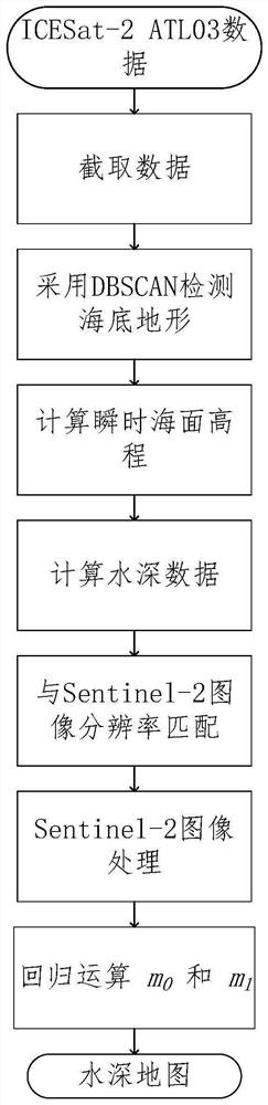
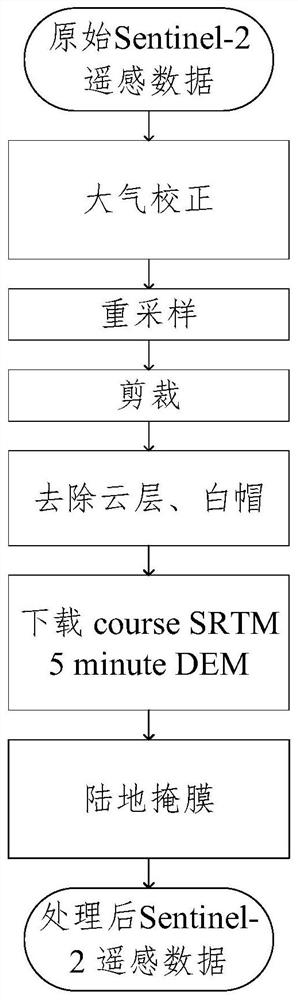
[0037] like figure 1 As shown, the water depth inversion method based on active and passive remote sensing fusion of spaceborne single photon laser of the present invention comprises the following steps:

[0038] S1: In order to improve the detection accuracy of subsequent DBSCAN, first intercept the original photon data of the underwater topography corresponding to the underwater terrain in the ATL03 data of ICESat-2 along the track distance direction; and then follow the vertical elevation direction ...


PUM


Abstract

The invention discloses a water depth inversion method based on satellite-borne single-photon laser active and passive remote sensing fusion. The method comprises the following steps: firstly, reading an ICESat-2ATL03 original data set; then extracting shallow water body water depth data by adopting a DBSCAN method; then selecting a Sentinel remote sensing image with less cloud in the region, and carrying out atmospheric correction, space cutting and land cloud layer masking on the Sentinel remote sensing image; substituting the water depth data detected in the ICESat-2 data into a band ratio empirical model for regression training to obtain parameters, and finally substituting the parameters into the Sentinel remote sensing image to invert a water depth map of the region. According to the invention, no in-situ sounding data is used as a control point, water depth measurement can be carried out in a region where airborne water depth measurement is not easy, and good measurement precision is maintained.

Description

technical field [0001] The invention belongs to the technical field of marine lidar, and in particular relates to a water depth inversion method based on active and passive remote sensing fusion of spaceborne single-photon laser. Background technique [0002] Obtaining detailed bathymetric and topographic information of coastal areas is one of the challenges in hydrology-related research and water resource management. High-resolution underwater terrain data is an essential reference for a wide range of coastal applications. Traditional carrier-based single-beam / multi-beam echo sounders and airborne lidar sounders are mainstream technologies for collecting shallow sea data and providing near-continuous underwater terrain maps. However, the disadvantages of these two methods are obvious. They are costly, inefficient and have sparse coverage. [0003] Satellite bathymetry is an important alternative measurement method for mapping the world's coastal waters. Satellite bathym...

Claims


Application Information

Patent Timeline
Patent Type & Authority Applications(China)
IPC IPC(8): G01S17/89
CPCG01S17/89
Inventor 陈鹏谢丛霜张镇华钟纯怿黄海清王天愚
Owner SECOND INST OF OCEANOGRAPHY MNR
Why Eureka
Try Eureka