Rapid database building method and system for land investigation

A land survey and fast technology, applied in the database field, can solve problems such as graphic element deformation and data loss, and achieve the effect of simple operation

Inactive Publication Date: 2022-02-08
刘琳
View PDF0 Cites 0 Cited by
  • Summary
  • Abstract
  • Description
  • Claims
  • Application Information

AI Technical Summary

Problems solved by technology

[0005] In order to make up for the deficiencies of the existing technology, the way to solve the existing CAD data into GIS data is mainly direct conversion, and direct conversion is likely to cause data loss, deformation of graphic elements and other problems, and cannot achieve the purpose of quickly presenting an accurate database. A rapid database building method and system for land survey proposed by the invention

Method used


Image

  • Rapid database building method and system for land investigation
  • Rapid database building method and system for land investigation
  • Rapid database building method and system for land investigation

Examples


Embodiment Construction

[0030] In order to make the technical means, creative features, goals and effects achieved by the present invention easy to understand, the present invention will be further described below in conjunction with specific embodiments.

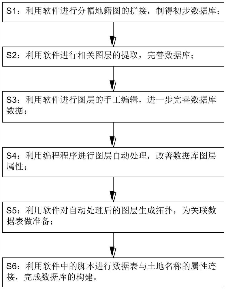
[0031] Such as figure 1 Shown, a kind of land investigation described in the present invention is used the method for quick database construction, and this method comprises the following steps:

[0032] S1: Use software to splice the cadastral map into pieces and make a preliminary database;

[0033] S2: Use software to extract relevant layers and improve the database;

[0034] S3: Use software to manually edit the layers to further improve the database data;

[0035] S4: Use the programming program to automatically process the layers and improve the properties of the database layers;

[0036] S5: Use the software to generate topology for the automatically processed layer to prepare for the associated data table;

[0037] S6: Use the script in...


PUM


Abstract

The invention belongs to the technical field of databases, and particularly relates to a rapid database building method and system for land investigation. The method comprises the following steps: S1, carrying out splicing on framing cadastral maps through software, and obtaining a preliminary database; S2, extracting related layers by using the software, and perfecting a database; S3, carrying out manual editing on the layers through the software, and further perfecting database data; S4, performing automatic layer processing by utilizing a programming program, and improving database layer attributes. According to the invention, cadastral data in a CAD format is converted into the cadastral data in a GIS data format through a combination of manual editing and automatic program processing, the cadastral data is associated with a cadastral attribute database through the GIS data, the cadastral spatial database can be rapidly established, the converted data is complete, graphic elements are not deformed; in the actual operation process, the method is time-saving, labor-saving, and simple to operate, the precision rate and accuracy are far higher than those of a database establishment mode in the prior art, and the effect is better.

Description

technical field [0001] The invention belongs to the technical field of databases, in particular to a method and system for rapidly building a database for land survey. Background technique [0002] With the continuous development of science and technology, the survey of rural land needs to be completed with high technology. my country has a vast territory and a large area, of which the rural area accounts for a large part. Therefore, the construction of a database for rural land survey data is a project. Onerous task. [0003] Carrying out surveys on rural land, and establishing the land data, basic farmland, land use and other data collected by the survey into a land database has positive significance for the centralized management and long-term management mechanism of rural areas. [0004] In the current existing technology, the establishment of the land survey database is mainly carried out by using CAD software, and the existing CAD data is converted into GIS data mainly...

Claims


Application Information

Patent Timeline
Patent Type & Authority Applications(China)
IPC IPC(8): G06F16/29G06F30/12
CPCG06F30/12G06F16/29
Inventor 刘琳
Owner 刘琳
Why Eureka
Try Eureka