Check patentability & draft patents in minutes with Patsnap Eureka AI!

Lake underwater terrain modeling method based on small amount of actually measured water depth data

A modeling method and lake water technology, applied in the field of lake hydrology, can solve the problem of inability to take into account accuracy and efficiency, and achieve the effect of simplifying field measurement workload, good applicability, and simple implementation

Pending Publication Date: 2022-04-12
NANJING INST OF GEOGRAPHY & LIMNOLOGY
View PDF0 Cites 2 Cited by
  • Summary
  • Abstract
  • Description
  • Claims
  • Application Information

AI Technical Summary

Problems solved by technology

Although the spatial inference method realizes the estimation of lake water depth and water volume on a large regional scale, due to the influence of sample size, distribution and representativeness, there are still large uncertainties in the water volume estimation results of individual lakes and lakes in some regions.
[0004] To sum up, the existing field measurement and spatial inference methods have their own defects, and cannot balance accuracy and efficiency

Method used


Image

  • Lake underwater terrain modeling method based on small amount of actually measured water depth data
  • Lake underwater terrain modeling method based on small amount of actually measured water depth data
  • Lake underwater terrain modeling method based on small amount of actually measured water depth data

Examples


Embodiment Construction

[0039] The specific implementation manner of the present invention will be further described in detail below in conjunction with the accompanying drawings and examples. The following examples are used to illustrate the present invention, but not to limit the scope of the present invention.

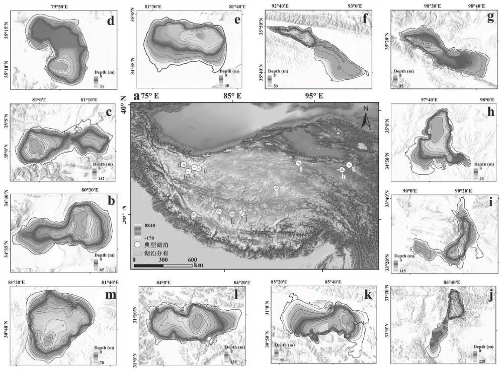
[0040] The embodiment of the present application is 12 lakes on the Qinghai-Tibet Plateau that have measured underwater terrain data. When selecting lakes, the differences in lake shape, size, spatial distribution, depth, etc. are fully considered, and strive to reflect the representativeness of the sample data. Since these lakes have shown an expansion trend since 2000, the SRTM DEM data collected in 2000 correspond to a period when the water area of ​​the lakes was relatively small. In the embodiment, the range of lake waters in 2000 is used as a benchmark, which can make full use of existing DEM data and reduce the uncertainty of underwater terrain modeling.

[0041] This embodiment i...


PUM


Abstract

The invention discloses a lake underwater terrain modeling method based on a small amount of actually measured water depth data, and the method comprises the steps: taking an elevation profile collected along the central axis of a lake as a terrain skeleton of the lake, and constructing a series of lake cross sections connecting a lakeside zone and the central axis on the basis of determining the range of a lakeside zone buffer zone; and the elevation value of the underwater area of the cross section is speculated under the constraint of the actually measured elevation value of the central axis by utilizing the known elevation of the lakeside zone. And finally, constructing a complete underwater terrain of the lake based on the cross section elevation and the central axis elevation one by one and spatial interpolation. The method does not need to carry out whole lake measurement, and greatly reduces the time and economic cost of lake field investigation work. The method is suitable for measurement work of large lakes in areas lack of data, and the constructed lake underwater topographic data can provide technical support for monitoring dynamic changes of lake water resources, revealing response characteristics of the lake water resources to global changes and the like.

Description

technical field [0001] The invention belongs to the field of lake hydrology, in particular to a lake underwater terrain modeling method based on a small amount of measured water depth data. Background technique [0002] Lakes store about 87% of the fresh water on the global surface and are an important source of water for human production and living (Downing et al., 2006). At the same time, lakes are also a key link in the terrestrial water cycle, which is of great significance to maintaining the stability of regional ecosystems (Woolway et al., 2020). The underwater topography of lakes is the basic attribute of lakes, which determines the size of lake water storage. Mastering information about underwater topography of lakes is an important basis for evaluating and monitoring lake water resources. Research provides important background data. [0003] Field survey is the most direct means to obtain the underwater topography of lakes, and underwater topography mapping can be...

Claims


Application Information

Patent Timeline
Patent Type & Authority Applications(China)
IPC IPC(8): G06T17/05
Inventor 宋春桥刘凯
Owner NANJING INST OF GEOGRAPHY & LIMNOLOGY
Features
  • R&D
  • Intellectual Property
  • Life Sciences
  • Materials
  • Tech Scout
  • Unparalleled Data Quality
  • Higher Quality Content
  • 60% Fewer Hallucinations
Learn More