Near-dam-area sub-basin unit division method and device and storage medium

A technology of sub-basins and watersheds, applied in the field of hydrology, can solve problems such as lack of basic basis and inability to guarantee rationality, and achieve the effects of reasonable division, stable and reliable data sources, and accurate and reasonable calculation results

Pending Publication Date: 2022-04-22
HOHAI UNIV +1
View PDF0 Cites 1 Cited by
  • Summary
  • Abstract
  • Description
  • Claims
  • Application Information

AI Technical Summary

Problems solved by technology

Since this method does not have a strong basis, its rationality cannot be guaranteed.

Method used


Image

  • Near-dam-area sub-basin unit division method and device and storage medium
  • Near-dam-area sub-basin unit division method and device and storage medium
  • Near-dam-area sub-basin unit division method and device and storage medium

Examples


Embodiment 1

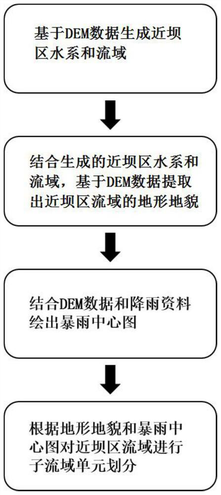
[0059] This embodiment introduces a method for dividing sub-basin units near the dam, including:

[0060] Generate water systems and watersheds near the dam based on DEM data;

[0061] Based on the generated water system and watershed near the dam, the topography of the watershed near the dam is extracted based on the DEM data;

[0062] Combining DEM data and rainfall data to draw a map of the center of the storm;

[0063] According to the topography and the rainstorm center map, the watershed near the dam is divided into sub-basin units.

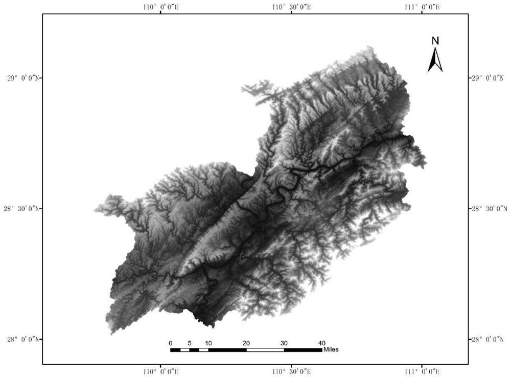
[0064] Such as Figure 1 to Figure 6 As shown, the application process of the sub-watershed unit division method in the near-dam area provided in this embodiment specifically involves the following steps:

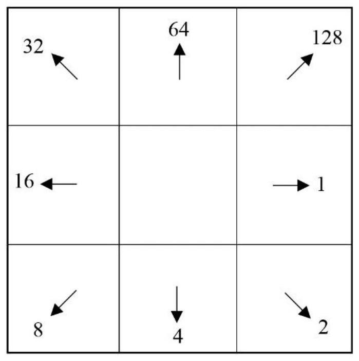
[0065] S1. A method for dividing sub-basin units in the near-dam area that comprehensively considers topography, landform and rainstorm center, characterized in that, in the step 1, the sub-watershed data, flow direction data, conflue...

Embodiment 2

[0125] This embodiment provides a sub-basin unit division device near the dam, including:

[0126] The first extraction unit is used to generate water systems and watersheds near the dam based on the DEM data;

[0127] The second extraction unit is used to combine the generated water system and watershed near the dam to extract the topography of the watershed near the dam based on the DEM data;

[0128] A rainstorm center map drawing unit is used to draw a rainstorm center map in combination with DEM data and rainfall data;

[0129] The sub-basin unit division unit is used to divide the watershed near the dam into sub-basin units according to the topography and the storm center map.

Embodiment 3

[0131] This embodiment provides a sub-basin unit division device near the dam, including a processor and a storage medium;

[0132] The storage medium is used to store instructions;

[0133] The processor is configured to operate in accordance with the instructions to perform the steps of any of the following methods:

[0134] Generate water systems and watersheds near the dam based on DEM data;

[0135] Based on the generated water system and watershed near the dam, the topography of the watershed near the dam is extracted based on the DEM data;

[0136] Combining DEM data and rainfall data to draw a map of the center of the storm;

[0137] According to the topography and the rainstorm center map, the watershed near the dam is divided into sub-basin units.


PUM


Abstract

The invention discloses a near-dam-area sub-drainage-basin unit division method and device and a storage medium. The method comprises the steps that a near-dam-area water system and a drainage basin are generated based on DEM data; in combination with the generated near-dam region water system and drainage basin, extracting the landform of the near-dam region drainage basin based on DEM data; drawing a rainstorm center map in combination with DEM data and rainfall data, and performing sub-basin unit division on the basin of the near-dam area according to the landform and the rainstorm center map; the method can clearly reflect confluence production modes of different underlying surfaces such as mountainous regions and plains, reflects the influence of a rainstorm center on confluence production, enables sub-basin unit division to be more reasonable, facilitates the consideration of basin confluence production physical characteristics, improves the flood forecasting precision, guarantees the stable and reliable data source, guarantees the accurate and reasonable calculation result, and is suitable for large-scale popularization and application. The method solves the problem of how to divide the watershed of the near-dam area in the humid area, and is beneficial to deep development of sub-watershed division research.

Description

technical field [0001] The invention relates to a sub-basin unit division method, device and storage medium in a near-dam area, and belongs to the field of hydrology technology. Background technique [0002] The watershed hydrological model is an important tool for flood forecasting by generalizing the description of the hydrological process, simulating a certain flood runoff process in the watershed with certain structures and parameters, and calculating the flow data at the outlet section. With the development of geographic information technology, remote sensing technology and computer science, even in areas with no data or data shortage, the geographical conditions of watersheds can be obtained through remote sensing images such as digital elevation model (DEM), land use and soil classification maps. [0003] There are characteristics such as the uneven distribution of rainfall, the uneven nature of the underlying surface, and the uneven nature of the river network on the...

Claims


Application Information

Patent Timeline
Patent Type & Authority Applications(China)
IPC IPC(8): G06F17/10G06T17/05
CPCG06F17/10G06T17/05Y02A10/40Y02A90/10
Inventor 李巧玲邝录章石彬龚定肖杨李致家沙永兵王立黄迎春臧帅宏童冰星王也伍昕谭君钟平晖王义
Owner HOHAI UNIV
Why Eureka
Try Eureka