City-level BIM (Building Information Modeling) data lightweight method and system based on multistage shelling algorithm

A lightweight, algorithmic technology, applied in image data processing, computing, 3D image processing, etc., can solve problems such as limiting the application of BIM data and unable to render city-level BIM data.

Pending Publication Date: 2022-04-29
CHINA ZHENGYUAN GEOMATICS CO LTD
View PDF0 Cites 0 Cited by
  • Summary
  • Abstract
  • Description
  • Claims
  • Application Information

AI Technical Summary

Problems solved by technology

At present, BIM data is mostly rendered in a single-scene and single-model manner, which cannot realize real-time rendering of city-level BIM data in the same scene, which limits the application of BIM data in CIM

Method used


Image

  • City-level BIM (Building Information Modeling) data lightweight method and system based on multistage shelling algorithm
  • City-level BIM (Building Information Modeling) data lightweight method and system based on multistage shelling algorithm
  • City-level BIM (Building Information Modeling) data lightweight method and system based on multistage shelling algorithm

Examples


Embodiment 1

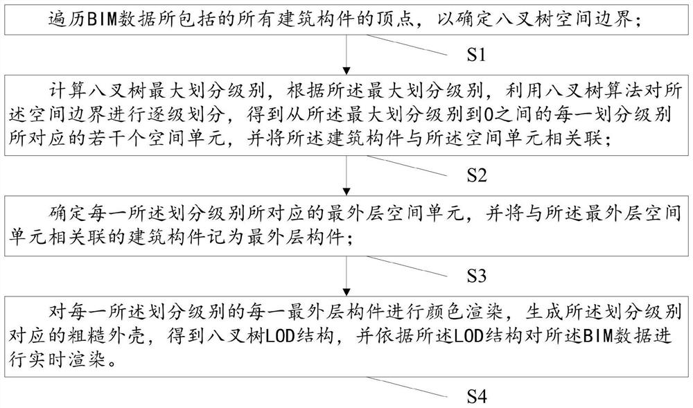
[0029] This embodiment is used to provide a method for lightweighting city-level BIM data based on a multi-level shelling algorithm, such as figure 1 and figure 2 As shown, the lightweight methods include:

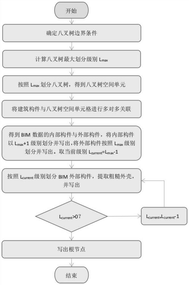
[0030] S1: traverse the vertices of all building components included in the BIM data to determine the space boundary of the octree; the space boundary is the smallest regular hexahedron including all the vertices;

[0031] BIM data includes: geometric data (with materials) and attribute data, what this embodiment wants to render is geometric data, and attribute data is used for query and analysis. The boundary of the octree space is a regular hexahedron, which just contains the vertices of all building components.

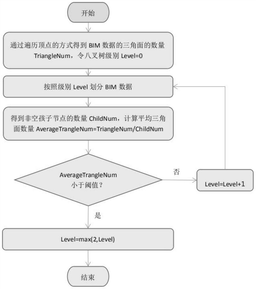
[0032] S2: Calculate the maximum division level of the octree, according to the maximum division level, use the octree algorithm to divide the space boundary step by step, and obtain the correspondence between each division level from the maximum division le...

Embodiment 2

[0072] This embodiment is used to provide a city-level BIM data lightweight system based on a multi-level shelling algorithm, such as Figure 6 As shown, the lightweight system includes:

[0073] The spatial boundary determination module M1 is used to traverse the vertices of all building components included in the BIM data to determine the spatial boundary of the octree; the spatial boundary is the smallest regular hexahedron including all the vertices;

[0074] The association module M2 is used to calculate the maximum division level of the octree, and according to the maximum division level, use the octree algorithm to divide the space boundary step by step, and obtain each partition between the maximum division level and 0. dividing a number of space units corresponding to the level, and associating the building component with the space unit; the space unit is a cube;

[0075] The outermost component determination module M3 is configured to determine the outermost spatial...


PUM


Abstract

The invention relates to a city-level BIM (Building Information Modeling) data lightweight method and system based on a multistage shelling algorithm, and relates to the technical field of data rendering. The method comprises the following steps: firstly, determining an octree space boundary, calculating the maximum division level of the octree, performing step-by-step division on the space boundary by using an octree algorithm to obtain a plurality of space units corresponding to each division level from the maximum division level to 0, and associating building components with the space units. And then determining an outermost layer space unit corresponding to each division level, and recording the building component associated with the outermost layer space unit as an outermost layer component. And finally, color rendering is carried out on each outermost layer component of each division level, rough shells corresponding to the division levels are generated to construct a complete and efficient octree LOD structure, real-time rendering is carried out on the BIM data according to the LOD structure, lightweight processing can be carried out on the urban BIM data, and real-time rendering of the urban BIM data is achieved.

Description

technical field [0001] The present invention relates to the technical field of urban-level BIM data rendering, in particular to a method and system for lightweighting urban-level BIM data based on a multi-level shelling algorithm. Background technique [0002] In the CIM technology system, BIM data, as the most basic unit for building a city's digital floor, will inevitably face the technical problems of city-level and large-scale rendering on the same screen. At present, BIM data is mostly rendered in a single-scene and single-model manner, which cannot realize real-time rendering of city-level BIM data in the same scene, which limits the application of BIM data in CIM. [0003] Based on this, there is an urgent need for a method and system capable of lightweight processing of city-level BIM data to achieve real-time rendering of city-level BIM data. Contents of the invention [0004] The purpose of the present invention is to provide a method and system for lightweighti...

Claims


Application Information

Patent Timeline
Patent Type & Authority Applications(China)
IPC IPC(8): G06T17/00G06T17/10G06T15/00G06F30/13
CPCG06T17/005G06T17/10G06T15/005G06F30/13
Inventor 卞玉龙邹伟林周文常松周新鹤
Owner CHINA ZHENGYUAN GEOMATICS CO LTD
Why Eureka
Try Eureka