Automatic land utilization data shrinking method

A data and land technology, which is applied in the field of automatic downsizing of land use data, can solve problems such as system stuck, hard borders of map spots, poor geographical features, etc., and achieve the effect of high quality, correct geographical features and element relations

Active Publication Date: 2022-05-10
THE THIRD GEOINFORMATION MAPPING INST OF MINISTRY OF NATURAL RESOURCES
View PDF16 Cites 6 Cited by
  • Summary
  • Abstract
  • Description
  • Claims
  • Application Information

AI Technical Summary

Problems solved by technology

At present, the most commonly used methods for automatic downsizing of land use data are based on spatial proximity and semantic proximity, calculating proximity models, establishing comprehensive knowledge rules, and developing tool sets such as patch merging and graph bending simplification to improve the automation of downsizing, similar to The solution is very dependent on the platform architecture and hardware environment in the face of massive map spots (more than 100,000). In actual operation, it usually takes several days to get the processing results, and the processing process is prone to memory overflow and system freezing. When the scope is large, it is necessary to perform physical partition and block first, and then carry out complex data seam repair. The processing process and parameter setting are very complicated. This process still requires a lot of manual participation, which seriously affects the operation efficiency.
Other automatic downsizing methods, such as automatic fusion and aggregation of terrain types and patches based on raster calculations to realize automatic comprehensive downsizing, this method less considers the geometric shape and distribution characteristics of elements, and can not take into account semantic information such as map spots level and affiliation , the geographical features are poorly maintained, and the synthesis of special maps such as narrow and long maps is unreasonable, resulting in hard edges and poor results after synthesis, which is difficult to directly apply to the production of land use maps

Method used


Image

  • Automatic land utilization data shrinking method
  • Automatic land utilization data shrinking method
  • Automatic land utilization data shrinking method

Examples


Embodiment Construction

[0066] The following will clearly and completely describe the technical solutions in the embodiments of the present invention with reference to the accompanying drawings in the embodiments of the present invention. Obviously, the described embodiments are only some, not all, embodiments of the present invention. Based on the embodiments of the present invention, all other embodiments obtained by persons of ordinary skill in the art without making creative efforts belong to the protection scope of the present invention.

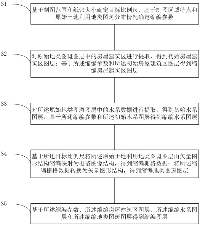
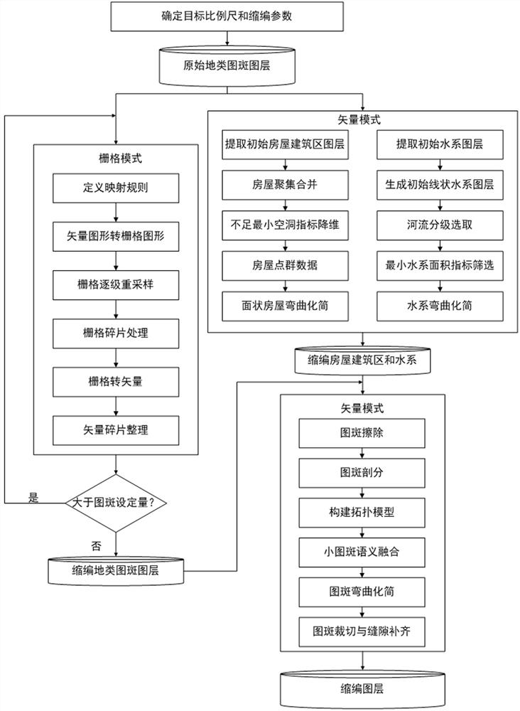
[0067] The purpose of the present invention is to provide a method for automatic reduction of land use data, which can effectively reduce the amount of data calculation and improve the efficiency of map reduction, and can also take into account the semantic information of land types and spots, and keep the regional geographical features and element relations of the map spots correct .

[0068] In order to make the above objects, features and advantages of the ...


PUM


Abstract

The invention relates to the technical field of map shrinking, in particular to an automatic land utilization data shrinking method, which comprises the following steps of: extracting a house building area and a water system from original data to perform independent shrinking, performing scale transformation through resampling and reclassification on the basis of a grid mode, performing pattern spot fragmentation processing, and obtaining a land utilization data matrix; according to the method, the data calculation amount can be remarkably reduced, the map shrinking efficiency can be remarkably improved, the semantic information of the land type pattern spots can be considered, the regional geographic features and the element relation of the pattern spots are kept correct, and the accuracy of the map spots is improved. And the high-quality land utilization map compilation requirement is met.

Description

technical field [0001] The invention relates to the technical field of map reduction, in particular to an automatic reduction method for land use data. Background technique [0002] A land use map is a thematic map that expresses the status quo, regional differences, and classification of land resources. When compiling maps, it is necessary to downsize large-scale land use data into different small-scale data according to different paper formats and different administrative regions. Since land use data has the characteristics of no overlap, no gaps, full coverage, and large quantities, high-quality data can be achieved. The automatic downsizing of the technology poses great challenges to the process design, algorithm design, strategy design and equipment environment. At present, the most commonly used methods for automatic downsizing of land use data are based on spatial proximity and semantic proximity, calculating proximity models, establishing comprehensive knowledge rul...

Claims


Application Information

Patent Timeline
Patent Type & Authority Applications(China)
IPC IPC(8): G06F16/587G06F16/583G06Q50/26G06Q50/08
CPCG06F16/587G06F16/583G06Q50/26G06Q50/08
Inventor 任东宇周启文学虎李维庆卢文渊梁磊
Owner THE THIRD GEOINFORMATION MAPPING INST OF MINISTRY OF NATURAL RESOURCES
Why Eureka
Try Eureka