Comprehensive remote sensing recognition method and system for hidden danger of glacial lake outburst

A technology for remote sensing identification and hidden dangers, which is applied in the field of comprehensive remote sensing identification methods and systems for glacial lake outburst hidden dangers. It can solve problems such as no distinction in importance, unclear target division, and incomplete evaluation system composition, and achieve good results and applicability. Strong, high engineering application value effect

Pending Publication Date: 2022-05-24
INST OF KARST GEOLOGY CAGS
View PDF0 Cites 4 Cited by
  • Summary
  • Abstract
  • Description
  • Claims
  • Application Information

AI Technical Summary

Problems solved by technology

According to the current research status at home and abroad, the risk assessment of glacial lake outburst disasters mainly includes risk assessment, vulnerability assessment, damage loss assessment, prevention and control engineering assessment, etc. There are still many problems to be solved, such as the existing landslide disaster risk assessment There are many methods, the composition of the evaluation system is not complete, the division of goals is not clear enough, and the importance of each index is not distinguished, etc.
In the existing technology, there is no systematic outburst risk assessment method, and there is no mature calculation method and verification method for glacial lake outburst risk assessment

Method used


Image

  • Comprehensive remote sensing recognition method and system for hidden danger of glacial lake outburst
  • Comprehensive remote sensing recognition method and system for hidden danger of glacial lake outburst

Examples


Embodiment Construction

[0033] The technical solutions in the embodiments of the present invention will be clearly and completely described below with reference to the accompanying drawings in the embodiments of the present invention. Obviously, the described embodiments are only a part of the embodiments of the present invention, rather than all the embodiments. Based on the embodiments of the present invention, all other embodiments obtained by those of ordinary skill in the art without creative efforts shall fall within the protection scope of the present invention.

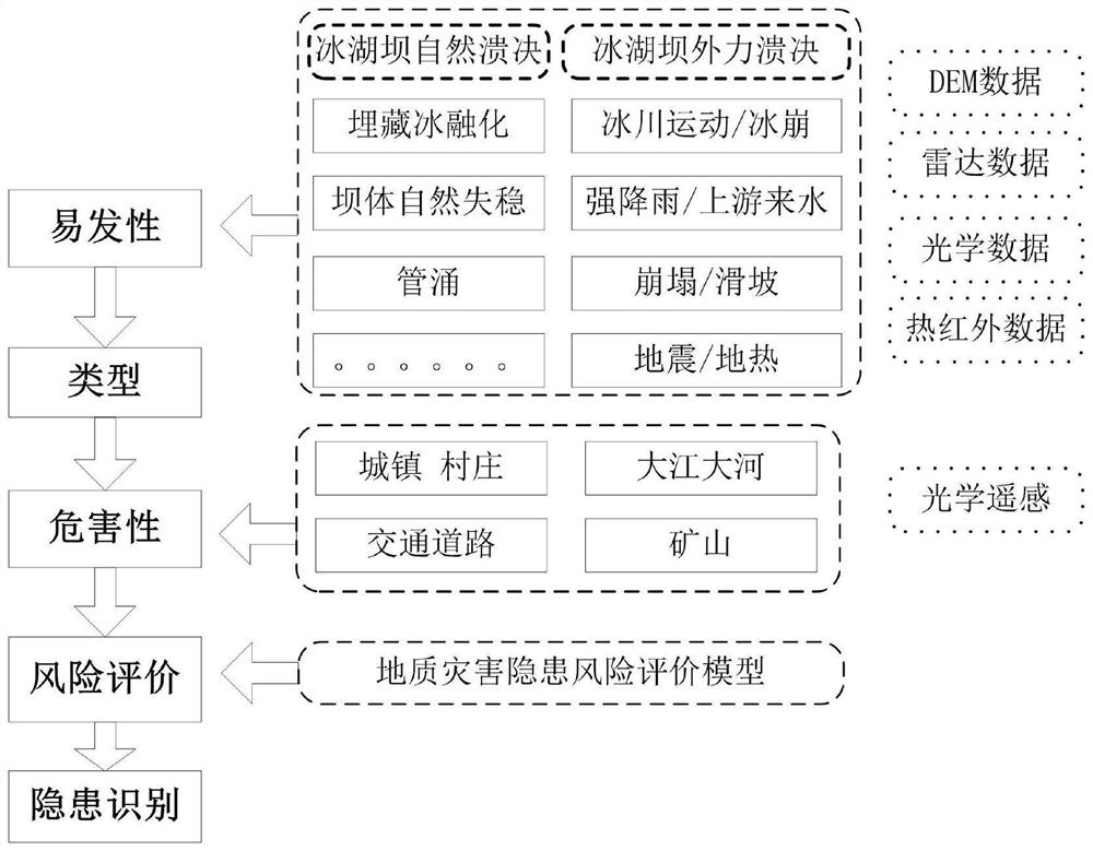
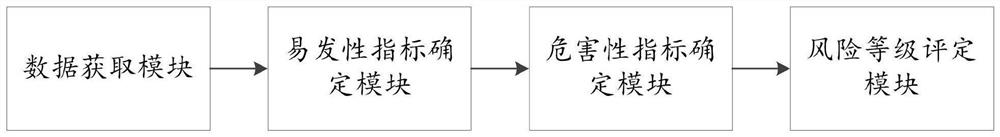
[0034] Embodiment 1 of the present invention discloses a comprehensive remote sensing identification method for hidden dangers of glacial lake outburst, such as figure 1 As shown, the specific steps include the following:

[0035] Step 1, obtaining environmental data, the environmental data includes DEM data, radar data, optical remote sensing image data and thermal infrared remote sensing data;

[0036] Step 2: Determine the suscep...


PUM


Abstract

The invention discloses a comprehensive remote sensing recognition method and system for hidden danger of glacial lake outburst, and relates to the technical field of disaster recognition. The method comprises the following specific steps: acquiring environment data, wherein the environment data comprises DEM data, radar data, optical remote sensing image data and thermal infrared remote sensing data; determining susceptibility indexes of glacial lake outburst disasters according to natural outburst factors of the glacial lake dam and external force outburst factors of the glacial lake dam in combination with the environmental data; determining the scale of a disaster-bearing body according to the multi-period optical remote sensing image data, and further determining the hazard index of the glacial lake outburst disaster; and by taking the susceptibility index and the hazard index as parameters, evaluating the risk level of the glacial lake outburst disaster hidden danger by using a geological disaster hidden danger risk evaluation model. The ice lake outburst disaster risk evaluation system constructed by the invention is more complete in composition content; the method can consider the influence of the harmfulness evaluation factor and the susceptibility evaluation factor on the evaluation scheme optimization decision at the same time, and is scientific, reasonable and high in applicability.

Description

technical field [0001] The invention relates to the technical field of disaster identification, and more particularly to a method and system for comprehensive remote sensing identification of hidden dangers of ice lake outburst. Background technique [0002] Glacial lake outburst is a natural phenomenon that occurs in the distribution area of ​​alpine glaciers. The occurrence of glacial lake collapse is often due to the occurrence of ice avalanches or ice landslides on the glaciers backed by the glacial lake. According to the current research situation at home and abroad, the risk assessment of glacial lake outburst disasters mainly includes risk assessment, vulnerability assessment, damage loss assessment, prevention and control engineering assessment, etc. There are still many problems that need to be solved, such as the existing landslide disaster risk assessment. There are various methods, the composition of the evaluation system is not complete, the target division is ...

Claims


Application Information

Patent Timeline
Patent Type & Authority Applications(China)
IPC IPC(8): G06V20/10G06N3/08G06Q10/06G06Q50/26
CPCG06N3/08G06Q10/0635G06Q10/06393G06Q50/26Y02A50/00
Inventor 程洋王永杨妍妨
Owner INST OF KARST GEOLOGY CAGS
Why Eureka
Try Eureka