
Landslide multi-temporal TLS point cloud precise registration method considering point pair reliability

A fine-registration and multi-temporal technology, applied in the fields of climate sustainability, ICT adaptation, image analysis, etc., can solve the problems of landslide micro-deformation detection failure, lack of high-precision registration, and difficult point-to-point consistency. Reduce the impact of artificial strength and landslide risk, good universality and practicability, and improve the effect of registration quality

Pending Publication Date: 2022-05-27
INNOVATION ACAD FOR PRECISION MEASUREMENT SCI & TECH CAS
View PDF0 Cites 0 Cited by
  • Summary
  • Abstract
  • Description
  • Claims
  • Application Information

AI Technical Summary

Problems solved by technology

However, for the multi-temporal point cloud registration of landslide dynamic scenes, due to factors such as noise, point density changes, target dynamic changes, and observation errors, it is difficult to maintain consistency between point pairs. Without high-precision registration results, it is easy to cause the failure of micro-deformation detection of landslides

Method used


Image

  • Landslide multi-temporal TLS point cloud precise registration method considering point pair reliability
  • Landslide multi-temporal TLS point cloud precise registration method considering point pair reliability
  • Landslide multi-temporal TLS point cloud precise registration method considering point pair reliability

Examples


Embodiment

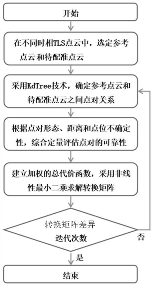
[0042] A landslide multi-temporal TLS point cloud fine registration method considering point pair reliability, which specifically includes the following steps:

[0043] Step 1: For TLS point clouds of different phases, select one of the point clouds as the reference point cloud, and the other point cloud as the point cloud to be registered. For the reference point cloud, KdTree is used to construct the spatial index of the reference point cloud.

[0044] Step 2: Traverse each to-be-registered point in the to-be-registered point cloud, and quickly retrieve the reference point in the reference point cloud that is closest to the to-be-registered point through the reference point cloud space index, thereby establishing the reference point p and the to-be-registered point q point-to-point relationship.

[0045] Step 3: In order to overcome the influence of factors such as small deformation field, point density with uneven spatial distribution, and observation error on the precise ...

Embodiment

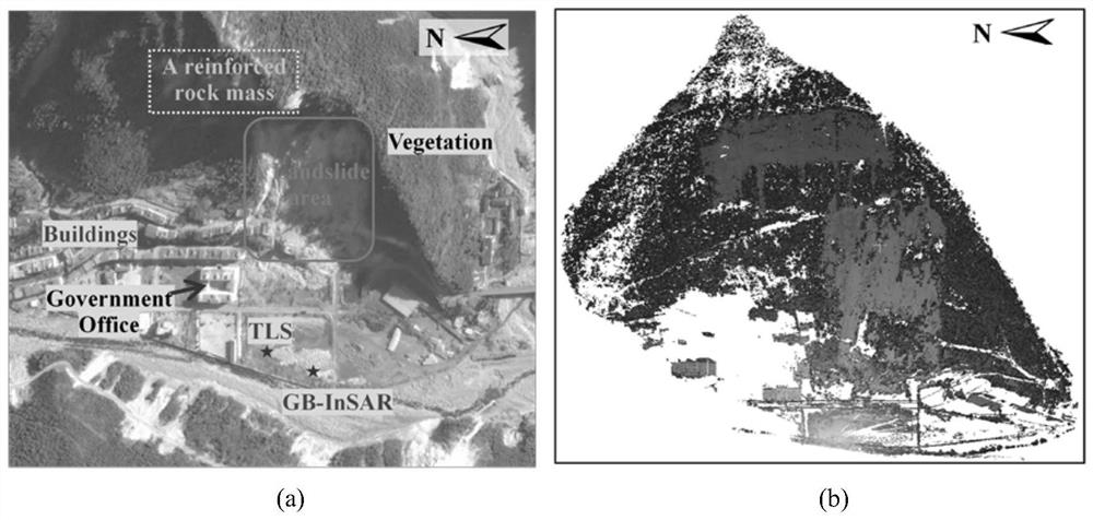
[0074] In order to illustrate the effectiveness of the present invention, a verification experiment of high-precision accurate registration of TLS point clouds in phase 2 of a landslide scene in Fengjie County, Chongqing was carried out. figure 2 It is the Google Earth optical image of a landslide scene somewhere in Fengjie County, Chongqing and the corresponding point cloud of the first phase of TLS. In September 2014, a heavy rainfall-induced landslide occurred in this area, with a daily rainfall of ~300mm. The landslide caused several buildings to be damaged, and the landslide was still moving at a slow speed after the landslide. In order to prevent secondary landslides, a Riegl VZ1000 was used for remote monitoring of slow-moving landslides. This example uses the data of September 23 and September 25 to display and compare the effects of the present invention.

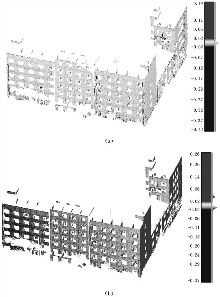
[0075] In order to verify the precise registration results of TLS point clouds in different phases realized b...


PUM


Abstract

The invention discloses a landslide multi-temporal TLS point cloud precise registration method considering point pair reliability. A reference point cloud and a to-be-registered point cloud are selected, and a point pair relation is established; constructing a similarity factor, a distance residual factor and a point location uncertainty factor for each point pair, and determining a comprehensive evaluation factor of the point pair; and establishing a point pair total cost function, obtaining a precise registration transformation matrix, performing coordinate transformation on the to-be-registered point cloud by using the precise registration transformation matrix, and iteratively optimizing the precise registration transformation matrix. According to the method, the point pair reliability is dynamically and quantitatively evaluated, so that the problem of low precision of multi-temporal point cloud precise registration caused by factors such as TLS point cloud noise, density change, target dynamic change and observation errors in a landslide dynamic scene is better solved, the multi-temporal point cloud registration quality can be effectively improved, and the method is further used for landslide tiny deformation detection.

Description

technical field [0001] The invention belongs to the field of ground laser radar point cloud processing in regional deformation monitoring of natural scenes of landslides, and particularly relates to a landslide multi-temporal TLS point cloud precise registration method considering point pair reliability. Background technique [0002] Usually, in the early stage of a landslide disaster, there will be small precursors of centimeter-level deformation on the surface. Therefore, it is of great scientific significance and practical value to accurately detect small deformations with high resolution and provide scientific and technological support for disaster management, early warning and forecasting, and mechanism research. Terrestrial Laser Scanning (TLS) is an all-weather, non-contact, high-precision, high-density three-dimensional information active acquisition method, which has good advantages in the regional monitoring of landslide deformation, and theoretically can achieve m...

Claims


Application Information

Patent Timeline
IPC IPC(8): G06T7/33
CPCG06T7/33G06T2207/10028Y02A90/10
Inventor 黄荣刚江利明汪汉胜
Owner INNOVATION ACAD FOR PRECISION MEASUREMENT SCI & TECH CAS
Learn More