All-sky imager calibration method based on lunar orientation

An all-sky imager and calibration method technology, which is applied in the direction of instruments, image analysis, image data processing, etc., can solve the problems of low accuracy of calibration parameters, limited calibration range, and complicated calibration process, so as to improve the efficiency of calibration and calculation The effect of accurate results and simple identification methods

Pending Publication Date: 2022-06-24
CHINA THREE GORGES CORPORATION +1
View PDF3 Cites 0 Cited by
  • Summary
  • Abstract
  • Description
  • Claims
  • Application Information

AI Technical Summary

Problems solved by technology

[0007] In order to solve the shortcomings of the above methods, the present invention discloses a method for calibrating an all-sky imager based on lunar azimuth, which can better solve the limitation of the calibration range caused by the distortion of t...

Method used


Image

  • All-sky imager calibration method based on lunar orientation
  • All-sky imager calibration method based on lunar orientation
  • All-sky imager calibration method based on lunar orientation

Examples


Embodiment Construction

[0079] The following description provides many different embodiments, or examples, for implementing various features of the present invention. The elements and arrangements described in the following specific examples are only used to concisely express the present invention, which are only examples, and are not intended to limit the present invention.

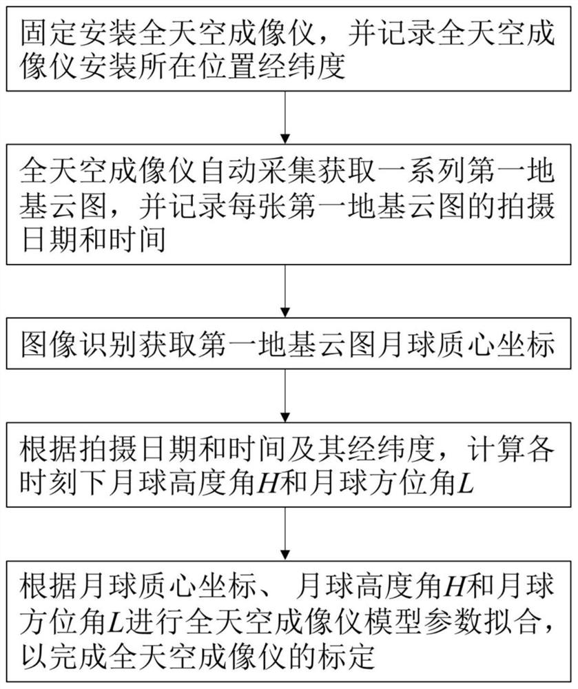
[0080] An all-sky imager calibration method based on lunar azimuth, such as figure 1 shown, including the following steps:

[0081] S1: Fix and install the all-sky imager, and record the longitude, latitude and time zone of the installation location of the all-sky imager;

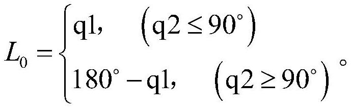
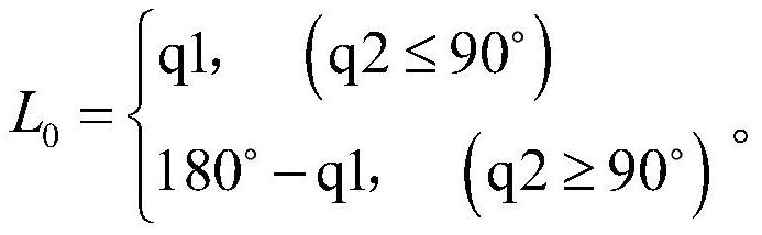
[0082] Set the longitude of the latitude and longitude to Lon, the east longitude to be positive, and the west longitude to be negative; set the latitude of the longitude and latitude to Lat, the north latitude to be positive, and the south latitude to be negative; set the time zone to tz, and the east time zone to be positive , the Western time zone is ne...


PUM


Abstract

The invention relates to the field of meteorological instrument calibration, in particular to an all-sky imager calibration method based on lunar orientation, which comprises the following steps: S1, fixing and installing an all-sky imager, and recording the longitude and latitude of the installation position of the all-sky imager; s2, setting the shooting interval of the all-sky imager, automatically collecting and obtaining a series of first foundation cloud pictures, and recording the shooting date and shooting time of each first foundation cloud picture; s3, carrying out image recognition to obtain a centroid coordinate of the moon in the first foundation cloud picture; s4, calculating the lunar elevation angle H and the lunar azimuth angle L at each shooting time according to the shooting date, the shooting time and the longitude and latitude of the installation position; and S5, performing parameter fitting on the all-sky imager according to the coordinates of the centroid of the moon, the elevation angle of the moon and the azimuth angle of the moon so as to complete calibration of the all-sky imager. The method has the technical characteristics of simplicity and rapidness in calibration, high calibration precision and low calibration cost.

Description

technical field [0001] The invention relates to the field of calibration of meteorological instruments, in particular to a calibration method of an all-sky imager based on lunar azimuth. Background technique [0002] Cloud movement is the main reason for short-term photovoltaic power generation fluctuations, and the strong spatiotemporal changes caused by instantaneous cloud changes will significantly affect the stability of solar power fed into the grid. Accurate predictions of the direction and speed of cloud movement for a specified time period in the future will greatly reduce this effect. Ground-based cloud map observation is an effective method for automatic monitoring and forecasting of cloud cover. This method obtains all the information of the local sky through an all-sky imager installed on the ground. [0003] Since the all-sky imager uses a fisheye lens with a field of view of 180 degrees, the images captured by it have serious radial distortion. Therefore, the...

Claims


Application Information

Patent Timeline
IPC IPC(8): G06T7/66G06T7/70G06T7/80G01W1/18
CPCG06T7/66G06T7/70G06T7/80G01W1/18
Inventor 王乾颜子璇苏营牛一森王良友邹良林孙长平宋记锋邹祖冰
Owner CHINA THREE GORGES CORPORATION
Why Eureka
Try Eureka