
On-orbit autonomous earth shadow calculation method and system for geostationary orbit satellite

A technology of geostationary orbit and calculation method, which is applied in the field of overall space vehicle technology and experiment and testing, can solve problems such as unexplained calculation-related content, and achieve the effects of avoiding satellite energy crisis, simplifying the calculation process, and reducing the amount of calculation

Pending Publication Date: 2022-06-28
SHANGHAI SATELLITE ENG INST
View PDF1 Cites 2 Cited by
  • Summary
  • Abstract
  • Description
  • Claims
  • Application Information

AI Technical Summary

Problems solved by technology

[0007] Zhu Xinghong, Miao Yuanqing, Yuan Shigeng, in the article "Optimization of Moon Shadow Event Prediction of Low-orbit Satellites" in Journal of Aircraft Measurement and Control, Volume 35, No. 2 (April 2016), proposed an The optimal forecasting method for moon shadow events of low-orbit satellites reduces the frequency of moon shadow forecasts from once a month to twice a year, which can effectively improve the efficiency of moon shadow event forecasting when low-orbit satellites are currently in orbit, and simplify the operation of low-orbit satellites. The task complexity of orbit operation management, but did not elaborate on the content of autonomous earth shadow calculation on geostationary orbit satellites

Method used


Image

  • On-orbit autonomous earth shadow calculation method and system for geostationary orbit satellite
  • On-orbit autonomous earth shadow calculation method and system for geostationary orbit satellite
  • On-orbit autonomous earth shadow calculation method and system for geostationary orbit satellite

Examples


Embodiment 1

[0074] A method for calculating an autonomous geography shadow of a geostationary orbit satellite on-orbit according to the present invention, comprising:

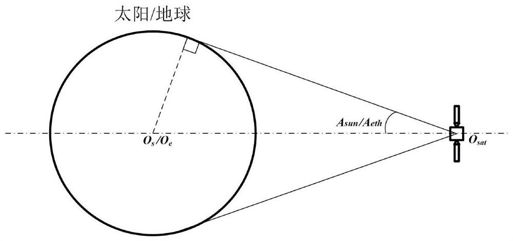
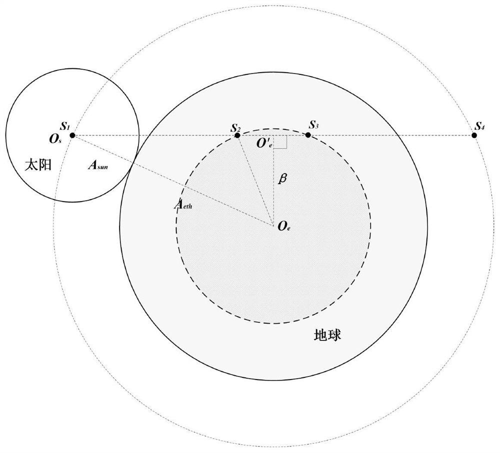
[0075] Step S1: Calculate the radius of the disk in the shadow area according to the opening angle of the sun disk and the disk opening angle of the earth;

[0076] Step S2: Calculate the cumulative seconds relative to GMT at midnight of the satellite according to the longitude of the sub-satellite point at the fixed-point position of the satellite;

[0077] Step S3: Calculate the sun altitude angle at midnight according to the accumulated seconds of the satellite at midnight relative to GMT;

[0078] Step S4: Calculate the angle that the sun crosses during the earth shadow period according to the radius of the disk of the earth shadow area and the altitude angle of the sun at midnight;

[0079] Step S5: Calculate the duration of the satellite earth shadow, the time when the satellite enters and exit the shadow, and deter...

Embodiment 2

[0130] Embodiment 2 is a preferred example of Embodiment 1

[0131] A method for calculating an autonomous geography shadow of a geostationary orbit satellite on-orbit according to the present invention, comprising:

[0132] Step S1: Calculate the opening angle of the solar disk according to the average radius of the sun and the average distance between the earth and the sun.

[0133] Step S2: Calculate the opening angle of the earth disk according to the average radius of the earth and the average distance between the stars and the earth.

[0134] Step S3: Calculate the Greenwich time at midnight at the fixed-point position of the satellite.

[0135] Step S4: Calculate the sun altitude angle at midnight.

[0136] Step S5: Calculate the duration of the satellite earth shadow.

[0137] Step S6 : Calculate the time of the satellite entering and leaving the shadow and determine the shadow area.

[0138] Specifically, the step S1 includes the following steps: according to the ...

Embodiment 3

[0160] Embodiment 3 is a preferred example of Embodiment 1 and / or Embodiment 2

[0161] The present invention provides a method for calculating the on-orbit autonomous ground shadow of a stationary orbit satellite, comprising the following steps:

[0162] Step 1: Calculate the opening angle of the solar disk according to the average radius of the sun and the average distance between the earth and the sun;

[0163] Step 2: Calculate the opening angle of the Earth's disk according to the Earth's average radius and the average star-to-earth distance;

[0164] Step 3: Calculate the Greenwich Mean Time at midnight at the fixed-point position of the satellite;

[0165] Step 4: Calculate the sun altitude angle at midnight;

[0166] Step 5: Calculate the duration of satellite earth shadow;

[0167] Step 6: Calculate the satellite entry and exit time and judge the shadow area.

[0168] Specifically, as described in step 1, the opening angle of the sun disk is the opening angle of t...


PUM


Abstract

The invention provides an in-orbit autonomous earth shadow calculation method and system for a geostationary orbit satellite. The method comprises the steps that S1, the radius of an earth shadow area disc is calculated according to a solar disc field angle and an earth disc field angle; s2, according to the longitude of the sub-satellite point at the fixed-point position of the satellite, calculating the accumulated second number of the midnight moment of the satellite relative to the Greenwich time; s3, calculating the solar altitude at the midnight moment according to the accumulated second number of the midnight moment of the satellite relative to the Greenwich time; s4, according to the radius of the disc in the earth shadow area and the solar altitude at the midnight, calculating the solar crossing angle in the earth shadow period; and S5, according to the angle crossed by the sun during the earth shadow period, calculating the earth shadow duration of the satellite and the time when the satellite enters and exits the shadow, and judging the earth shadow area. The method does not depend on ground control processing, earth shadow judgment is autonomously completed in orbit, and satellite energy crisis and safety problems caused by underreporting of a ground system are avoided.

Description

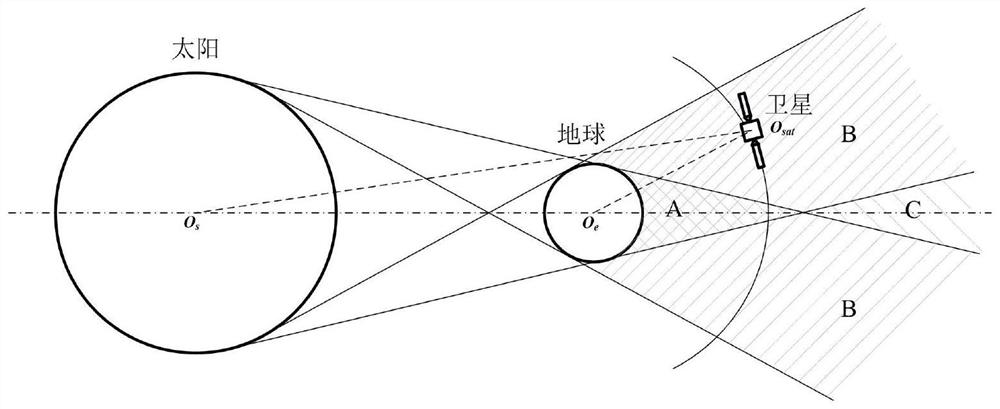
technical field [0001] The invention relates to the overall technology and the test and testing technology of space vehicles, and in particular, to a method and system for calculating the on-orbit autonomous ground shadow of a geostationary orbit satellite. Background technique [0002] During the orbit of the satellite around the earth, when the earth is between the sun and the satellite and the three are exactly in a straight line, the earth will block the light from the sun to the satellite, so the shadow of the earth will be cast on the satellite to form an earth shadow, as shown in the appendix. figure 1 shown. Due to the different conditions of the sun at the location of the satellite, the earth shadow area can be divided into full shadow area, penumbra area and annular shadow area. figure 1 As shown in the figure, A is a schematic diagram of the full shadow area, B is a schematic diagram of the penumbra area, and C is a schematic diagram of the annular shadow area. ...

Claims


Application Information

Patent Timeline
IPC IPC(8): G06F17/10
CPCG06F17/10
Inventor 王皓许海玉李绿萍边志强曾擎徐凯
Owner SHANGHAI SATELLITE ENG INST
Learn More