Water surface area reconstruction method for oblique photography three-dimensional model data of unmanned aerial vehicle

A 3D model and oblique photography technology, applied in the field of 3D modeling, can solve the problems of a large number of manual participation, unsatisfactory water surface models, low efficiency, etc., and achieve the effect of automatic reconstruction and high promotion and application value

Pending Publication Date: 2022-07-08
NANJING INST OF GEOGRAPHY & LIMNOLOGY
View PDF0 Cites 2 Cited by
  • Summary
  • Abstract
  • Description
  • Claims
  • Application Information

AI Technical Summary

Problems solved by technology

For some special application fields (such as ecological environment monitoring, water pollution supervision, etc.), real water surface information (water color, floating objects, etc.) is an important basis for decision-making, and the preset water surface model cannot meet the demand
Although some commercial software (such as 3ds Max, DP-Modeler, etc.) can repai

Method used


Image

  • Water surface area reconstruction method for oblique photography three-dimensional model data of unmanned aerial vehicle
  • Water surface area reconstruction method for oblique photography three-dimensional model data of unmanned aerial vehicle
  • Water surface area reconstruction method for oblique photography three-dimensional model data of unmanned aerial vehicle

Examples


Example Embodiment

[0045] Example 1

[0046] This embodiment illustrates the specific implementation of the present invention.

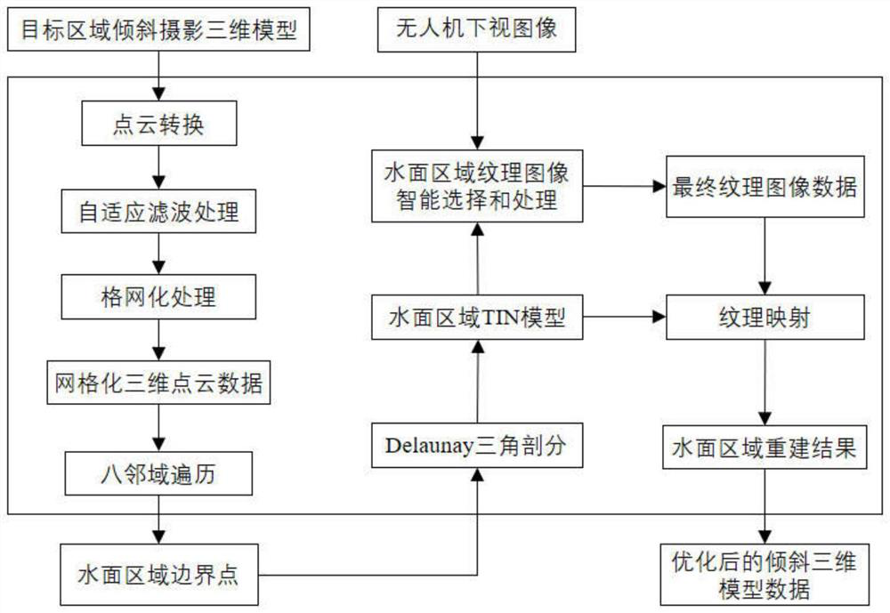
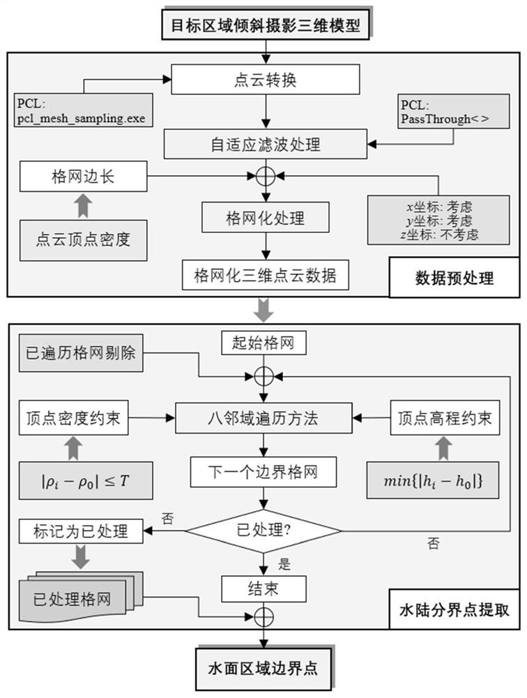
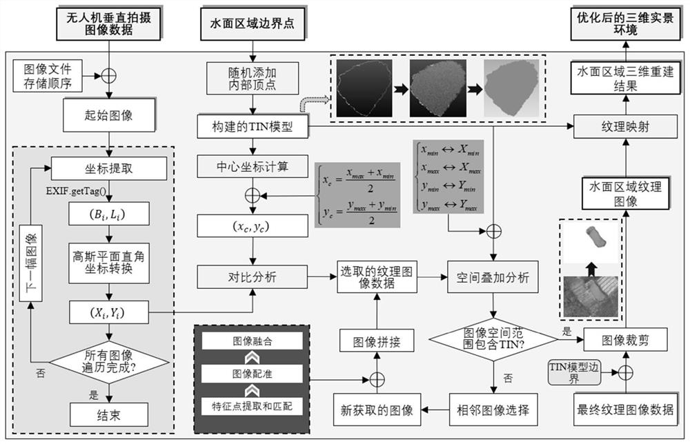
[0047] In this example, the water surface area in the tilted 3D model data of the UAV is quickly reconstructed. The specific implementation process is as follows: first, convert the original 3D model data into point cloud data; then use the through filtering method to process the acquired point cloud data, reduce the number of processed point clouds to improve the efficiency of algorithm execution, and analyze the acquired point cloud data. The data is gridded; based on the point cloud data features of the water surface area, the water boundary is extracted, and the triangulation irregular network (TIN) model of the water surface area is further constructed; based on the EXIF ​​information of the drone's down-view image, intelligent selection and processing The texture image data of the water surface area is generated; finally, the texture image is mapped to the TIN m...

Example Embodiment

[0078] Example 2

[0079] This embodiment describes the evaluation results of the reconstruction efficiency and accuracy of the water surface area based on the three-dimensional model data of the oblique photography of the UAV of the present invention.

[0080] Ten UAV oblique photography 3D model data including water surface area and original UAV image data were selected (see Figure 10 ), using the method designed in the present invention to carry out three-dimensional reconstruction of the water surface area, and the configuration of the computer used is shown in Table 1.

[0081] Table 1 Computer configuration information for the implementation of the experiment

[0082]


PUM


Abstract

The invention relates to a water surface region reconstruction method for unmanned aerial vehicle oblique photography three-dimensional model data, and the method comprises the steps: converting the unmanned aerial vehicle oblique photography three-dimensional model data into point cloud data, and carrying out the grid processing; designing a water surface region boundary extraction method by using density and elevation characteristics of water surface region point cloud data, and rapidly screening water area boundary point clouds; based on the water area boundary extraction result, constructing a triangulated irregular network model of the water surface area; intelligent selection of a water surface area texture image is realized based on EXIF information of downward-looking image data of the unmanned aerial vehicle, and an intelligent processing algorithm is designed to generate final water surface area texture image data in combination with a spatial inclusion relation between the texture image and a TIN model, so that water surface area reconstruction is realized. According to the method, an existing unmanned aerial vehicle oblique photogrammetry three-dimensional modeling technical system can be perfected, real water surface information can be rapidly and automatically reconstructed, and the method has high application and popularization value in the fields of twinborn drainage basins, twinborn cities and the like.

Description

technical field [0001] The invention belongs to the field of three-dimensional modeling, and in particular relates to a method for rapidly reconstructing a water surface area for oblique photography of three-dimensional model data of an unmanned aerial vehicle. Background technique [0002] UAV oblique photogrammetry technology provides a new and effective method for rapid 3D reconstruction of large-area geospatial elements, and has been widely used in 3D modeling at the scale of cities and watersheds. Compared with other geospatial elements, the water surface area is easily affected by factors such as wind, waves, reflection, etc., which makes it impossible to achieve rapid reconstruction of the water surface area with the existing technology. Therefore, in the existing 3D visualization systems, the real water surface information of rivers and lakes is rarely displayed. In general application scenarios, real water surface information is rarely concerned, and a preset (imag...

Claims


Application Information

Patent Timeline
IPC IPC(8): G06T17/05G06T17/20G06T15/04G06T3/40
CPCG06T17/05G06T17/20G06T15/04G06T3/4038G06T2200/08G06T2200/32Y02A90/30
Inventor 邱银国焦亚沁段洪涛罗菊花
Owner NANJING INST OF GEOGRAPHY & LIMNOLOGY
Why Eureka
Try Eureka