
Multi-line laser radar road boundary line extraction method

A multi-line laser, extraction method technology, applied in radio wave measurement systems, instruments, measurement devices, etc., can solve problems such as affecting the extraction of road boundary lines, increasing the number of empty grids, and affecting the accuracy of road boundary line extraction.

Pending Publication Date: 2022-07-12
SUN YAT SEN UNIV +1
View PDF0 Cites 0 Cited by
  • Summary
  • Abstract
  • Description
  • Claims
  • Application Information

AI Technical Summary

Problems solved by technology

[0004] Specifically, the voxel-based method has the advantages of fast processing speed and accurate classification, but due to the sparsity of the point cloud, it is difficult to achieve satisfactory results: too small a grid will lead to an increase in the number of empty grids, slowing down Processing speed; if the grid is too large, the boundary grid will contain road point clouds, which will affect the accuracy of road boundary line extraction
As shown in the Chinese invention application published on May 14, 2019: A road edge detection method based on laser point cloud, it belongs to the method based on turning point features; The current mainstream method, but the existing technology in this area is easily disturbed by roadside turning points and noise points: first, there is interference in the road, and there are usually other vehicles on the road when the vehicle is driving on the road, even if there are only a few vehicles on the road , the vehicle is still easy to be identified as the road boundary, and the vehicle will block the road boundary. In addition to the vehicle point cloud, the road surface point cloud also affects the extraction of the road boundary line; second, there are many disturbances on the roadside, and the road surface and roadside buildings , The point cloud features of the connection between trees and pedestrians are similar to the road boundary features, and can be easily identified as road boundaries
Therefore, the prior art still has certain limitations

Method used


Image

  • Multi-line laser radar road boundary line extraction method
  • Multi-line laser radar road boundary line extraction method
  • Multi-line laser radar road boundary line extraction method

Examples


Embodiment 1

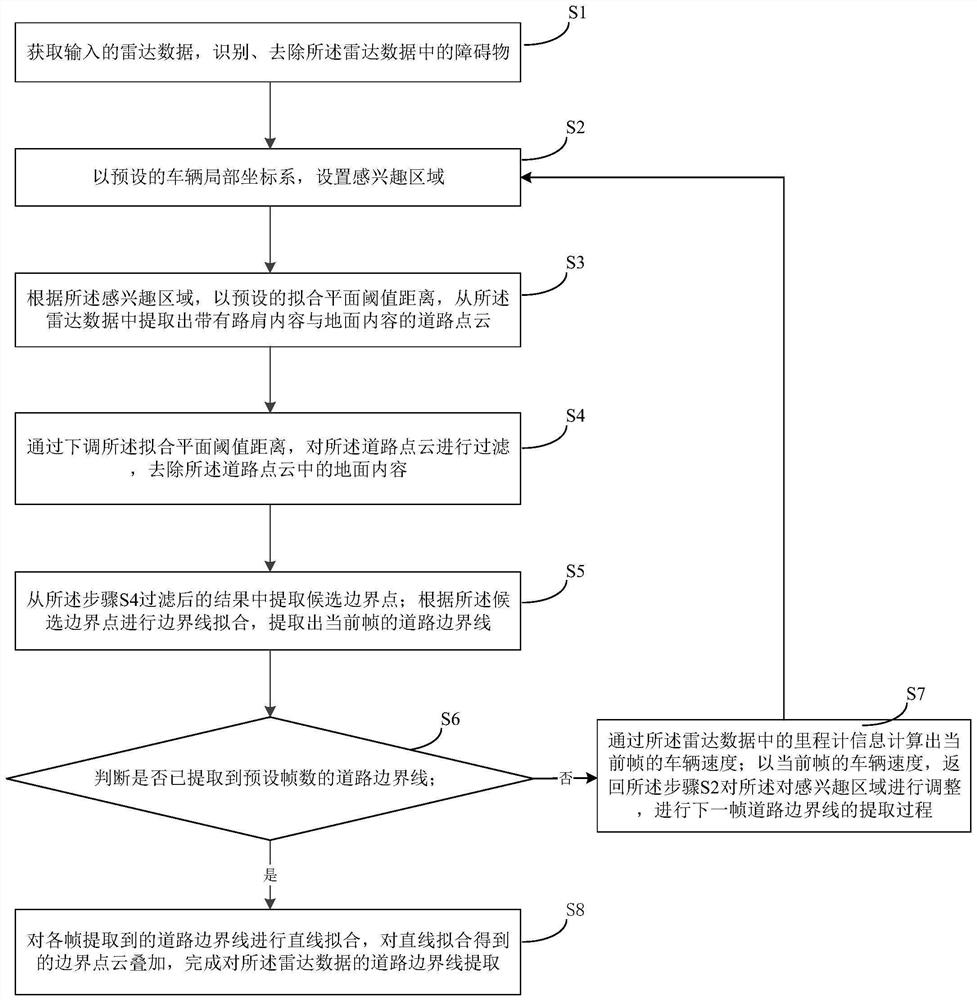
[0050] Please refer to figure 1 , a multi-line lidar road boundary line extraction method, comprising the following steps:

[0051] S1, obtain input radar data, identify and remove obstacles in the radar data;

[0052] S2, set the region of interest with the preset vehicle local coordinate system;

[0053] S3, extracting a road point cloud with road shoulder content and ground content from the radar data with a preset fitting plane threshold distance according to the region of interest;

[0054] S4, by lowering the fitting plane threshold distance, filtering the road point cloud to remove the ground content in the road point cloud;

[0055] S5, extracting candidate boundary points from the result filtered in step S4; performing boundary line fitting according to the candidate boundary points, and extracting the road boundary line of the current frame;

[0056] S6, determine whether the road boundary line of the preset number of frames has been extracted; if not, execute ste...

Embodiment 2

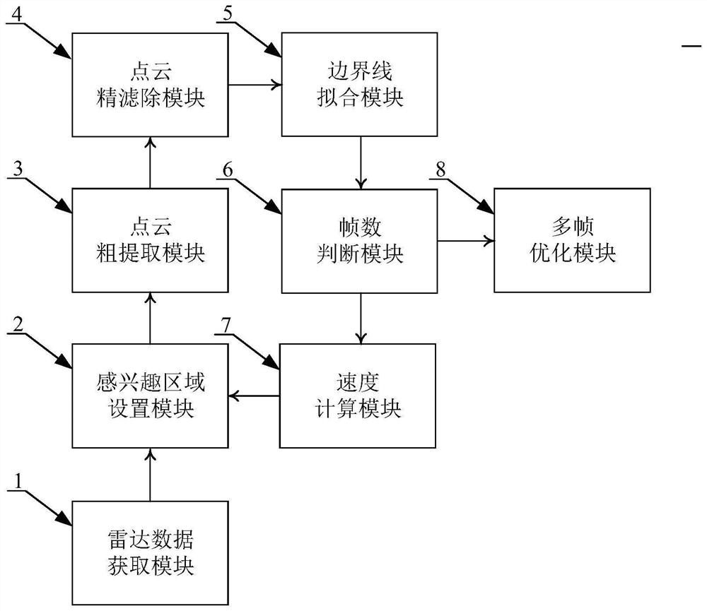
[0089] A multi-line lidar road boundary line extraction system, see image 3 , including radar data acquisition module 1, region of interest setting module 2, point cloud coarse extraction module 3, point cloud fine filtering module 4, boundary line fitting module 5, frame number judgment module 6, speed calculation module 7 and multi-frame The optimization module 8; the region of interest setting module 2 is connected to the radar data acquisition module 1, the point cloud rough extraction module 3 and the speed calculation module 7; the point cloud fine filtering module 4 is connected to the point cloud rough extraction module 3 and boundary line fitting module 5; Described frame number judgment module 6 connects described boundary line fitting module 5, speed calculation module 7 and multi-frame optimization module 8; Wherein:

[0090] The radar data acquisition module 1 is used for acquiring input radar data, identifying and removing obstacles in the radar data;

[0091] ...

Embodiment 3

[0099] A storage medium having a computer program stored thereon, and when the computer program is executed by a processor, implements the steps of the method for extracting a road boundary line of a multi-line laser radar in Embodiment 1.


PUM


Abstract

The invention provides a multi-line laser radar road boundary line extraction method for the limitation of the prior art. Under the condition that the accuracy is guaranteed, the cost of a hardware system is greatly reduced, and popularization and updating of a high-precision map are facilitated; according to the method, more accurate space information is provided, and the actual application precision can be achieved; according to the method, boundary points are extracted through ground features, distance features and straight line features instead of turning point features, interference caused by noise points in a road and roadside buildings, trees, grass and the like is eliminated, and road boundary lines are accurately extracted; according to the method, points are directly processed and are not influenced by point cloud resolution. In addition, the curve area is fitted through multi-frame fusion and ROI adjustment, and accurate road boundary extraction can be performed on the curve area; and meanwhile, road boundary information can be supplemented through multi-frame fusion, and various types of road boundaries can be accurately and completely extracted.

Description

technical field [0001] The invention relates to the technical field of automatic driving and automatic construction of high-precision maps, in particular to the application of multi-line radar in the above technical field, and more particularly, to a method for extracting road boundary lines of multi-line laser radar. Background technique [0002] Road boundary lines are the basic elements of high-precision maps. How to accurately and completely extract road boundary lines is the key to automatically constructing high-precision maps. At the same time, the road boundary line is also an important local information for the autonomous driving vehicle when it loses the positioning signal, and relies on the road boundary line information to avoid driving out of the lane. Multi-line radar has accurate spatial information, but the development of detection technology is not perfect due to low point cloud density. At present, the main problems faced by the use of multi-line lidar to ...

Claims


Application Information

Patent Timeline
IPC IPC(8): G01S17/89G01S7/495
CPCG01S17/89G01S7/495
Inventor 熊会元朱桃宏尹文成张学岭潘跃龙
Owner SUN YAT SEN UNIV
Learn More