Ground circular area satellite transit rapid forecasting method based on geocentric angle

A circular area and geocentric angle technology, which is used in ground navigation, design optimization/simulation, navigation calculation tools, etc., can solve problems such as large amount of calculation, low efficiency, limited application, etc., and achieves low calculation amount and high calculation speed. , the effect of rapid forecast

Active Publication Date: 2022-07-12
中国人民解放军32035部队
View PDF6 Cites 3 Cited by
  • Summary
  • Abstract
  • Description
  • Claims
  • Application Information

AI Technical Summary

Problems solved by technology

[0004] However, the above method is computationally intensive, resulting in low efficiency
In addition, for some non-coope...

Method used


Image

  • Ground circular area satellite transit rapid forecasting method based on geocentric angle
  • Ground circular area satellite transit rapid forecasting method based on geocentric angle
  • Ground circular area satellite transit rapid forecasting method based on geocentric angle

Examples


Embodiment 1

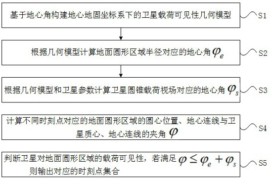
[0043] See figure 1 , figure 1 It is a schematic flowchart of a method for fast forecasting satellite transit in a ground circular area based on a geocentric angle provided by an embodiment of the present invention, which includes:

[0044] S1: Construct the satellite payload visibility geometric model in the geocentric geofixed coordinate system based on the geocentric angle.

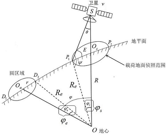
[0045] Specifically, the satellite payload visibility geometric model is the earth center, the ground plane, the satellite mass center, the satellite roll angle, the geocentric angle corresponding to the radius of the ground circular area, the connection line between the earth center and the satellite mass center, and the ground circular area. The geometric relationship formed by the connection between the position of the center of the circle and the center of the earth, and the angle between each connection. See figure 2 , figure 2 is the schematic diagram of the visibility geometric model of th...


PUM


Abstract

The invention discloses a ground circular area satellite transit rapid forecasting method based on a geocentric angle. The method comprises the following steps: constructing a satellite load visibility geometric model under an earth-centered earth-fixed coordinate system based on the geocentric angle; calculating a geocentric angle corresponding to the radius of the ground circular area according to the geometric model; calculating a geocentric angle corresponding to a satellite cone load view field according to the geometric model and the satellite parameters; calculating an included angle between the circle center position and the geocenter connecting line of the ground circular area corresponding to different time points and the mass center and the geocenter connecting line of the satellite; and judging the load visibility of the satellite to the ground circular area, and if the load visibility is met, outputting a corresponding time point set. According to the method, the geocentric angle is utilized to construct the satellite load visibility geometric model, the visibility window time period of the satellite to the ground circular target area can be rapidly calculated through the geometric relationship, rapid forecasting of satellite transit is achieved, calculation is little, and the calculation speed is high; and specific load parameters of the satellite do not need to be obtained, and the method is suitable for practical use.

Description

technical field [0001] The invention belongs to the technical field of satellite transit forecast, and in particular relates to a method for rapid forecasting of satellite transit in a circular area on the ground based on the geocentric angle. Background technique [0002] In space, there are man-made earth satellites of various shapes and sizes running non-stop. They are responsible for tasks such as reconnaissance of enemy situation, transmission of information, and detection of earth resources. When the satellite passes through the ground target area, the time range in which the target can be observed under the constraints of the field of view is called the visible time window. It is the basis for satellites to perform observation tasks on ground targets. Any observation task must be performed within the visible window. Time window calculation is of great significance and can provide satellite transit time for ground targets. [0003] At present, there is no efficient ge...

Claims


Application Information

Patent Timeline
IPC IPC(8): G06F30/20G01C21/04G01C21/20
CPCG06F30/20G01C21/04G01C21/20
Inventor 钟卫军曹申艺杨宁谷磊何健邓小桐王涵
Owner 中国人民解放军32035部队
Why Eureka
Try Eureka