Facade line automatic extraction method and equipment based on airborne building LiDAR point cloud

An automatic extraction and building technology, applied in the field of photogrammetry and remote sensing, can solve the problems of cumbersome process, partial elevation position, wall corner position easily affected by segmentation threshold, etc., to improve the measurement accuracy and work efficiency.

Pending Publication Date: 2022-07-12
WUHAN UNIV
View PDF0 Cites 4 Cited by
  • Summary
  • Abstract
  • Description
  • Claims
  • Application Information

AI Technical Summary

Problems solved by technology

Limited by the limitation of the LiDAR scanning angle of view, the early research on building position extraction from airborne LiDAR point cloud was mostly carried out on the roof point cloud. The extracted roof outline and the position of the wall facade have deviations, and eaves correction is usually required, which is a cumbersome process. , inefficient
Although related tech

Method used


Image

  • Facade line automatic extraction method and equipment based on airborne building LiDAR point cloud
  • Facade line automatic extraction method and equipment based on airborne building LiDAR point cloud
  • Facade line automatic extraction method and equipment based on airborne building LiDAR point cloud

Examples


Embodiment Construction

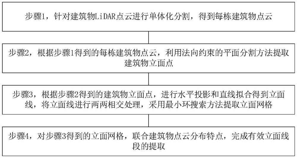
[0030] In order to make the purposes, technical solutions and advantages of the embodiments of the present invention clearer, the technical solutions in the embodiments of the present invention will be clearly and completely described below with reference to the accompanying drawings in the embodiments of the present invention. Obviously, the described embodiments These are some embodiments of the present invention, but not all embodiments. Based on the embodiments of the present invention, all other embodiments obtained by those of ordinary skill in the art without creative efforts shall fall within the protection scope of the present invention. In addition, the technical features in the various embodiments or a single embodiment provided by the present invention can be arbitrarily combined with each other to form a feasible technical solution. This combination is not restricted by the sequence of steps and / or the structural composition mode, but must be in the order of Those...


PUM


Abstract

The invention provides an airborne building LiDAR point cloud-based facade line automatic extraction method and equipment. The method comprises the following steps: step 1, carrying out monomer segmentation on LiDAR point clouds of buildings to obtain point clouds of all the buildings; step 2, according to the point cloud of each building obtained in the step 1, utilizing a normal constraint plane segmentation method to extract building facade points; step 3, according to the building facade points obtained in the step 2, performing horizontal projection and straight line fitting to obtain facade lines, performing pairwise intersection processing on the facade lines, and extracting facade grids by adopting a minimum ring search method; and step 4, for the facade grids obtained in the step 3, completing extraction of effective facade line segments in combination with building point cloud distribution characteristics. The method can automatically extract the vertical face line of the multi-storey building, does not have field measurement work, effectively improves the working efficiency, and improves the measurement precision compared with a manual measurement means.

Description

technical field [0001] Embodiments of the present invention relate to the technical fields of photogrammetry and remote sensing, and in particular, to a method and device for automatically extracting elevation lines based on LiDAR point clouds of airborne buildings. Background technique [0002] Buildings are an important part and basic element of a city, and their spatial location characteristics can reflect the urban spatial distribution pattern and development trend. The building facade surveying and mapping is the basis for the design and construction of building reconstruction and expansion projects. Traditional building facade surveying and mapping is usually carried out by manual measurement or with the help of surveying and mapping instruments and close-range photogrammetry. The advantages of these surveying and mapping methods are that the operation is relatively simple, but the collected information is small, the cycle is long, and the cost of manpower and material...

Claims


Application Information

Patent Timeline
IPC IPC(8): G06T7/11G06T7/136G06T7/66
CPCG06T7/11G06T7/136G06T7/66G06T2207/10028G06T2207/20101Y02A90/10
Inventor 徐景中周志宇胡翔云饶宸
Owner WUHAN UNIV
Why Eureka
Try Eureka