
Level gauge distance measurement method based on image enhancement

A technology for distance measurement and image enhancement, applied in image enhancement, height/level measurement, image analysis, etc., can solve problems such as poor image quality, small barcode imaging, blurred edges, etc., achieve distinct features, improve recognition accuracy, and improve The effect of image quality

Active Publication Date: 2022-07-12
山东沃能安全技术服务有限公司
View PDF6 Cites 1 Cited by
  • Summary
  • Abstract
  • Description
  • Claims
  • Application Information

AI Technical Summary

Problems solved by technology

In actual measurement, most of them are field operations, and the leveling system will be affected by the measurement environment and measurement distance, such as uneven brightness distribution of the scale, partial occlusion of the barcode image, the impact of ambient temperature changes on the imaging quality of the barcode scale, or atmospheric disturbance. Uncertainty factors brought about lead to poor image quality collected by CCD, especially in long-distance measurement. In the image collected by CCD, the barcode image is small and the edges are blurred, which reduces the measurement accuracy of the digital level.
[0004] In the existing technology, there are mainly several methods such as geometric leveling method, total station triangular elevation method and laser tracker elevation measurement. Although these two methods have fast measurement speed and high efficiency, they cannot meet the requirements of high-precision measurement.

Method used


Image

  • Level gauge distance measurement method based on image enhancement
  • Level gauge distance measurement method based on image enhancement
  • Level gauge distance measurement method based on image enhancement

Examples


Embodiment 1

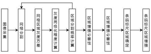
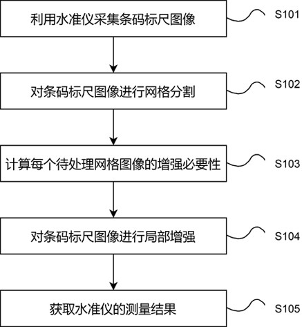
[0048] The embodiment of the present invention provides a method for measuring the distance of a leveling instrument based on image enhancement, such as figure 1 and figure 2 shown, including:

[0049] S101. Use a level to collect a bar code ruler image

[0050] The image collected by the CCD camera of the digital level is processed, and the selective image enhancement of the image is carried out according to the characteristic information of each position in the image, so as to ensure the accuracy of the distance measurement result of the level. Therefore, it is necessary to first collect an image including a barcode ruler captured by a level as a barcode ruler image.

[0051] S102. Perform grid segmentation on the barcode ruler image

[0052] Since the level needs to analyze the barcode scale in the image, in order to ensure the accuracy of image segmentation, it is necessary to highlight the characteristics of the barcode scale to facilitate the subsequent process of ba...

Embodiment 2

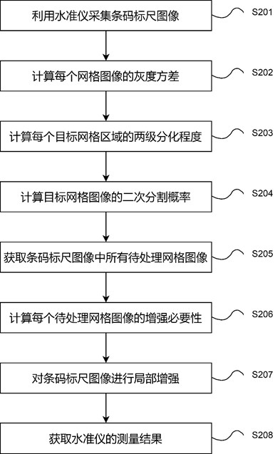
[0060] The embodiment of the present invention provides a method for measuring the distance of a leveling instrument based on image enhancement, such as figure 1 and image 3 shown, the specific contents include:

[0061] S201. Use a level to collect a bar code ruler image

[0062] The image collected by the CCD camera of the digital level is processed, and the selective image enhancement of the image is carried out according to the characteristic information of each position in the image, so as to ensure the accuracy of the distance measurement result of the level. Therefore, it is necessary to first collect the image captured by the level as the bar code ruler image.

[0063] The CCD camera of the digital level is used to collect environmental images, and the collected images are denoised to obtain a barcode ruler image, which is used for subsequent image processing and analysis.

[0064] S202. Calculate the grayscale variance of each grid image

[0065] The traditional ...


PUM


Abstract

The invention discloses a level gauge distance measurement method based on image enhancement, and relates to the field of artificial intelligence. Comprising the following steps: S1, collecting bar code scale images by using a level gauge; s2, performing grid segmentation on the bar code scale image to obtain a to-be-processed grid image; s3, the enhancement necessity of each to-be-processed grid image is calculated according to the gray variance of each to-be-processed grid image; s4, clustering each to-be-processed grid image to obtain a bar code scale region, and enhancing the bar code scale image through adaptive segmentation of the bar code scale region; and S5, matching and positioning the bar code scale areas in the enhanced image and the template image to obtain a measurement result of the level gauge. According to the invention, the bar code scale area is determined according to the bipolar phenomenon of the surface gray value of the bar code scale, and image enhancement is carried out on the bar code scale area, so that the features of the bar code scale are more obvious, and the subsequent bar code scale image segmentation and bar code recognition accuracy are improved.

Description

technical field [0001] The present application relates to the field of artificial intelligence, in particular to a method for measuring distance of a level based on image enhancement. Background technique [0002] The level is an instrument that establishes a horizontal line of sight to measure the height difference between two points on the ground. Its working principle is to measure the height difference between ground points according to the principle of leveling. Among them, the digital level is widely used due to its high precision, objective reading data and high efficiency. The digital level adopts the reading principle of the correlation method. First, the pseudo-random code representing the ruler is stored in the memory of the digital level, and it is used as a reference signal; the image of the barcode ruler on the CCD is used as the measurement signal, and the two signals are compared and read to obtain the line of sight. Height and line of sight to complete the ...

Claims


Application Information

Patent Timeline
Patent Type & Authority Applications(China)
IPC IPC(8): G06T7/11G06T7/73G06T7/90G06T5/00G06K9/62G01C5/00G06V10/762
CPCG06T7/11G06T7/90G01C5/00G06T7/73G06F18/23G06F18/22G06T5/94
Inventor 牛传业牛天亓超
Owner 山东沃能安全技术服务有限公司
Learn More