Map data updating method and electronic equipment

A technology of map data and update method, which is applied in database update, image data processing, geographic information database, etc. It can solve the problems of small changes that cannot be detected, the number cannot be spread, and the accuracy of map elements is poor, so as to achieve significant update timeliness , Improve the timeliness of updates, and improve the effect of usability

Pending Publication Date: 2022-08-09
AUTONAVI
View PDF0 Cites 2 Cited by
  • Summary
  • Abstract
  • Description
  • Claims
  • Application Information

AI Technical Summary

Problems solved by technology

Since the cost of professional collection vehicles for high-precision maps is too high, the number cannot be spread out, and it cannot meet the collection and update of large-scale geographic data. Therefore, the current update of high-precision maps mainly uses front-mounted or rear-mounted visual sensors on crowdsourcing vehicles. and positioning sensors to collect road images and corresponding location information, and then use image processing technology to identify and extract high-precision map elements on the collected road images and calculate the three-dimensional coordinates of the elements, and then make a difference with the existing high-precision map data and update geographic data
However, this type of method has the following disadvantages: 1) The ranging accuracy based on the monocular image collected by a camera is not high, the accuracy of the extracted map elements is poor, and the fine difference cannot be realized, which is difficult to meet the accuracy requirements of high-precision map update. The change cannot be detected, which will damage the update quality of the map; 2) The visual sensor is sensitive to light, and insufficient light (such as at night) will cause the system to fail, and it is difficult to meet the freshness requirements of high-precision maps (such as daily updates)

Method used


Image

  • Map data updating method and electronic equipment
  • Map data updating method and electronic equipment
  • Map data updating method and electronic equipment

Examples


Embodiment Construction

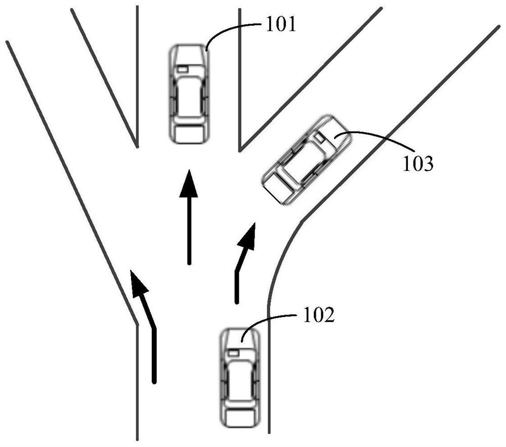
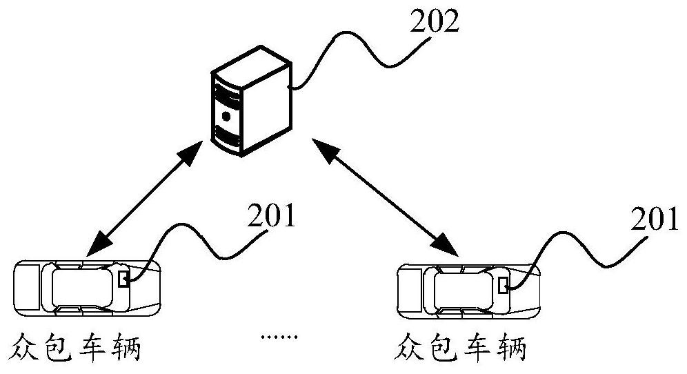
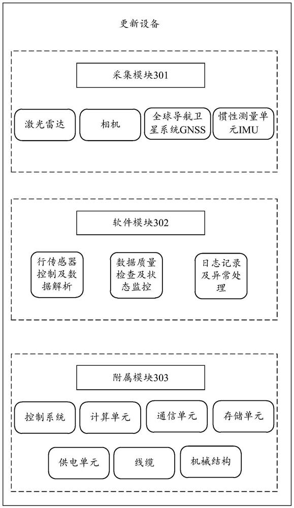
[0121] Hereinafter, exemplary embodiments of the embodiments of the present disclosure will be described in detail with reference to the accompanying drawings so that those skilled in the art can easily implement them. Also, for the sake of clarity, parts unrelated to describing the exemplary embodiments are omitted from the drawings.

[0122] In embodiments of the present disclosure, it should be understood that terms such as "comprising" or "having" are intended to indicate the presence of features, numbers, steps, acts, components, parts, or combinations thereof disclosed in this specification, and are not intended to be The presence or addition of one or more other features, numbers, steps, acts, components, parts, or combinations thereof is excluded.

[0123] In addition, it should be noted that the embodiments of the present disclosure and the features of the embodiments may be combined with each other under the condition of no conflict. The embodiments of the present d...


PUM


Abstract

The embodiment of the invention discloses a map data updating method and electronic equipment, and the method comprises the steps: obtaining the geographic data of a target area, and the geographic data comprises geographic point cloud data; extracting a to-be-updated map element vector in the target area based on the geographic data; after the target area is matched and aligned with a corresponding area in a pre-stored high-precision map, element difference is carried out on the to-be-updated map element vector and an existing map element vector in the corresponding area, and whether map elements in the target area are changed or not is determined; and if the map elements in the target area change, carrying out map data updating processing. According to the technical scheme, the updating precision and updating timeliness of the high-precision map can be improved.

Description

technical field [0001] The embodiments of the present disclosure relate to the technical field of map making, and in particular, to a method for updating map data and an electronic device. Background technique [0002] With the development of science and technology, advanced assisted driving and automatic driving have become the hotspot of technology research because they can help drivers to drive safely. At present, one of the technical realization paths of advanced assisted driving and autonomous driving needs to rely on "high-precision maps". Compared with ordinary maps, high-precision maps will express the real world in a finer and more precise manner. The large-scale, high-quality, and high-quality updates of high-precision maps are the most critical issues in the field of high-precision maps, which determine the map when driving. Functional safety used. Because the cost of professional collection vehicles for high-precision maps is too high, the number cannot be spre...

Claims


Application Information

Patent Timeline
Patent Type & Authority Applications(China)
IPC IPC(8): G06F16/23G06F16/29G06T3/00
CPCG06F16/235G06F16/29G06T3/0068G06T2207/10028
Inventor 曹亮罗星宋志丹陈岳袁剑峰
Owner AUTONAVI
Why Eureka
Try Eureka