Method for inverse computing digital surficial height from image of synthetic aperture radar in all polarization by one time of flight

A terrestrial digital, fully polarized technology, applied in the direction of reflection/re-radiation of radio waves, utilization of re-radiation, measurement devices, etc., can solve the problem of high technical difficulty of INSAR

Inactive Publication Date: 2003-05-07
FUDAN UNIV
View PDF0 Cites 15 Cited by
  • Summary
  • Abstract
  • Description
  • Claims
  • Application Information

AI Technical Summary

Problems solved by technology

[0003] However, the related technologies of INSAR are very difficult, and not

Method used


Image

  • Method for inverse computing digital surficial height from image of synthetic aperture radar in all polarization by one time of flight
  • Method for inverse computing digital surficial height from image of synthetic aperture radar in all polarization by one time of flight
  • Method for inverse computing digital surficial height from image of synthetic aperture radar in all polarization by one time of flight

Examples


Embodiment 1

[0054] Embodiment 1, Guangdong Huizhou area.

[0055] Using the L-band data observed by SAR SIR-C on Guangdong Province, China on October 4, 1994, provided by the Jet Propulsion Laboratory (JPL) of the California Institute of Technology, the center of the image is at about (114.561°E, 22.815°N). The size of a pixel is 12.5×12.5m 2 . The incident angle of the SAR at the center of the image is 32.85°. image 3 It is a backscattered vv, hh, hv total power image with a size of 512×512 pixels intercepted from the original image, and its center is located at (114.7826°E, 23.1359°N), located in Huizhou, Guangdong Province, China.

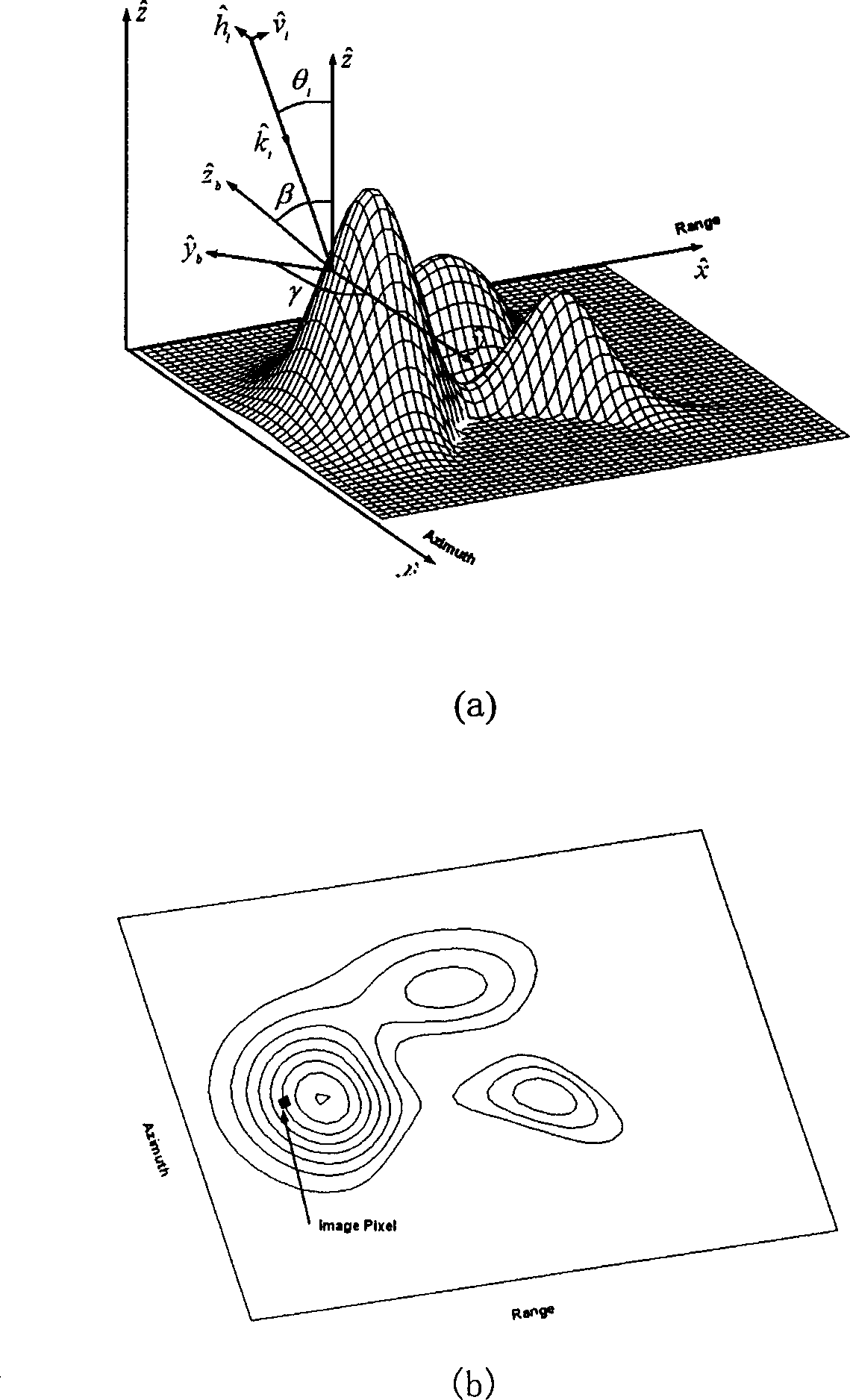
[0056] from image 3 You can see the undulating hills running north-south. In order to highlight the main trend of the terrain, we have omitted some more subtle local undulations. Note that the horizontal azimuth γ defined here is the slope trend and orientation angle (such as figure 1 (a) shown).

[0057] S A and S R The calculation result is...

Embodiment 2

[0059] Embodiment 2, Alishan area, Taiwan

[0060] Using the L-band data observed by SAR SIR-C on Taiwan, China on October 4, 1994 provided by the Jet Propulsion Laboratory (JPL) of the California Institute of Technology, the center of the image is about (120.964°E, 23.487°N), each The pixel size is 12.5×12.5m 2 . The incident angle of the SAR at the center of the image is 32.85°. Figure 8 It is a backscattered vv, hh, hv total power image with a size of 512×512 pixels intercepted from the original image, and its center is (120.8626°E, 23.6659°N), located in the Alishan area of ​​Taiwan, China.

[0061] Intuitive terrain structure and very simple ground elevation map reflected by inverted DEM and original SAR image [13] It is basically the same, and the trend of its main terrain is also consistent with the light and dark texture of the SAR image.


PUM


Abstract

This invention relates to a method for inversing ground digit altitude of single flying complete polarization synthetic aperture radar image using fully polarized scattering Mueller matrix solution to derive orientation angle psi migration, with the help of transformation of euler angle to set up relations among psi migration and tilted surface picture element range angle beta and horizontal azimuth gamma determine by three stokes arameters. Under the condition of only single flying SAR data, adaptive threshold value binary and image morphology refinement are used to determine gamma and beta and ground range azimuth slope and horizontal azimuth slope, therefore, using complete multiple mesh alogirhtm value to resolve Poisson equation of DEM to get inversion of DEM.

Description

field of invention [0001] The invention belongs to the technical field of space remote sensing and communication, and in particular relates to a method for retrieving ground digital elevation by space-borne synthetic aperture radar. Background technique [0002] Spaceborne Synthetic Aperture Radar (SAR) polarization measurement and imaging technology is one of the most important advances in space earth observation and remote sensing in the 1990s. It can observe the scattered echoes of the ground and ocean with high resolution all-weather and can image them. In recent years, on the basis of SAR, interferometric SAR (INSAR) technology with coherent flight or dual-antenna flight has been developed. In 2000, Lee et al. of the U.S. Naval Laboratory used an approximate scattering amplitude function to prove that the extreme value of the echo generated by ground undulations is at the incident polarization angle ψ≠0. This migration of ψ≠0 can be used to calculate the elevation of g...

Claims


Application Information

Patent Timeline
IPC IPC(8): G01S13/42G01S13/90
Inventor 金亚秋罗霖
Owner FUDAN UNIV
Why Eureka
Try Eureka