Symmetric system sampling technique for estimating area change by different scale remote sensing data

A technology of remote sensing data and symmetrical systems, applied in the direction of measuring devices, instruments, etc., can solve problems such as the lack of a system for urban land use, the limitations of science and accuracy, and the failure to make full use of low-resolution remote sensing image resources. Achieve the effect of facilitating data sharing, strong sample representativeness, and improved timeliness

Inactive Publication Date: 2005-08-10
RENMIN UNIVERSITY OF CHINA
View PDF0 Cites 28 Cited by
  • Summary
  • Abstract
  • Description
  • Claims
  • Application Information

AI Technical Summary

Problems solved by technology

However, the above studies used the existing auxiliary statistical data of the National Bureau of Statistics and remote sensing high-resolution image data, failed to make full use of low-resolution remote sensing image resources, and mostly used random sampling or

Method used


Image

  • Symmetric system sampling technique for estimating area change by different scale remote sensing data
  • Symmetric system sampling technique for estimating area change by different scale remote sensing data
  • Symmetric system sampling technique for estimating area change by different scale remote sensing data

Examples


Embodiment Construction

[0010] This invention is an innovative technology in the intersecting fields of statistics, remote sensing engineering, agricultural and forestry engineering, urban planning and land resources survey. The basic technical scheme and best way to realize this invention can be summarized as the following steps:

[0011] 1. Determination of sampling frame

[0012] Sorting is based on the number of changes in the research objects in each grid, and the appropriate variable is selected as the sorting mark. The specific method is as follows:

[0013] (1) According to the research area and the nature of the research object, select the international standard fraction of topographic map as the basic unit of sampling;

[0014] (2) Collect the original remote sensing images of the research area in the past or other information that can reflect the original distribution of the research objects (such as land use maps, etc.);

[0015] (3) Obtain the current low-resolution remote sensing image...
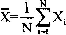
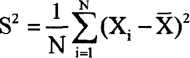
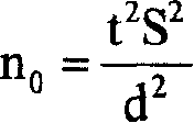

PUM


Abstract

The present invention relatesto a method for estimating area factor change of surface fealures of crop planted area, forest covered area and urban land-use area, etc. by using remote sensing data with different dimensions as data source and adopting symmetrical system sampling technique. Said invention utilizes remote sensing image with middle and low resolution, such as MODIS and TM to construct sampling basic unit, uses the primary estimate value of area changed dimension as auxiliary variable quantity to make collation, and adopts symmetrical system sampling technique to select sample point with strong representativeness, and utilizes the sample information to calculate the area change of researched object in whole region.

Description

technical field [0001] The invention relates to a method for estimating changes in the area elements of land features such as crop planting area, forest coverage area, urban land area, etc., using remote sensing data of different scales as data sources and using symmetrical system sampling technology. It is mainly used in remote sensing engineering, agricultural and forestry engineering , urban planning, land and resources survey and statistics. Background technique [0002] Remote sensing data of different scales refers to remote sensing images with different spatial resolutions. The symmetric systematic sampling technique refers to sorting the auxiliary variables, obtaining sample points in a symmetrical way, and estimating the overall variables. my country is a big country with agricultural and forestry products, and it is in a period of rapid urbanization. The crop planting area, forest coverage area, and urban land area are all basic information of the country's social...

Claims


Application Information

Patent Timeline
IPC IPC(8): G01B21/28
Inventor 王汶赵彦云钟卫王作成郝志敏
Owner RENMIN UNIVERSITY OF CHINA
Why Eureka
Try Eureka