Navigation apparatus

Active Publication Date: 2005-03-03
APPLE INC
View PDF2 Cites 17 Cited by
  • Summary
  • Abstract
  • Description
  • Claims
  • Application Information

AI Technical Summary

Benefits of technology

The invention has been made in view of the above problems, and it is an object of the invention to provide a navigation apparatus, which can enhance a degr

Problems solved by technology

Therefore, there is such a problem that it is difficult to understand own current location and grasp the actual situation around own current location through the map screen.
This is because it is difficult to display the vertical positional relationship such as roads in a solid crossing, on the map screen and because actually a large number of roads, buildings, and the like that are not displayed on the map screen are present.
However, the aerial photograph screen (prepared by using the aerial photograph data) does not in all cases make it possible to understand own current location more easily and grasp the situation around

Method used


Image

  • Navigation apparatus
  • Navigation apparatus
  • Navigation apparatus

Examples


Embodiment Construction

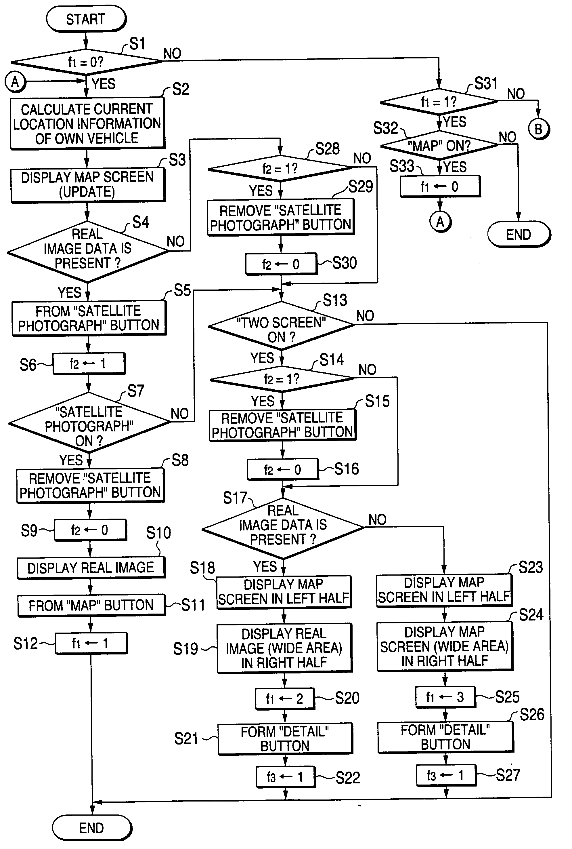
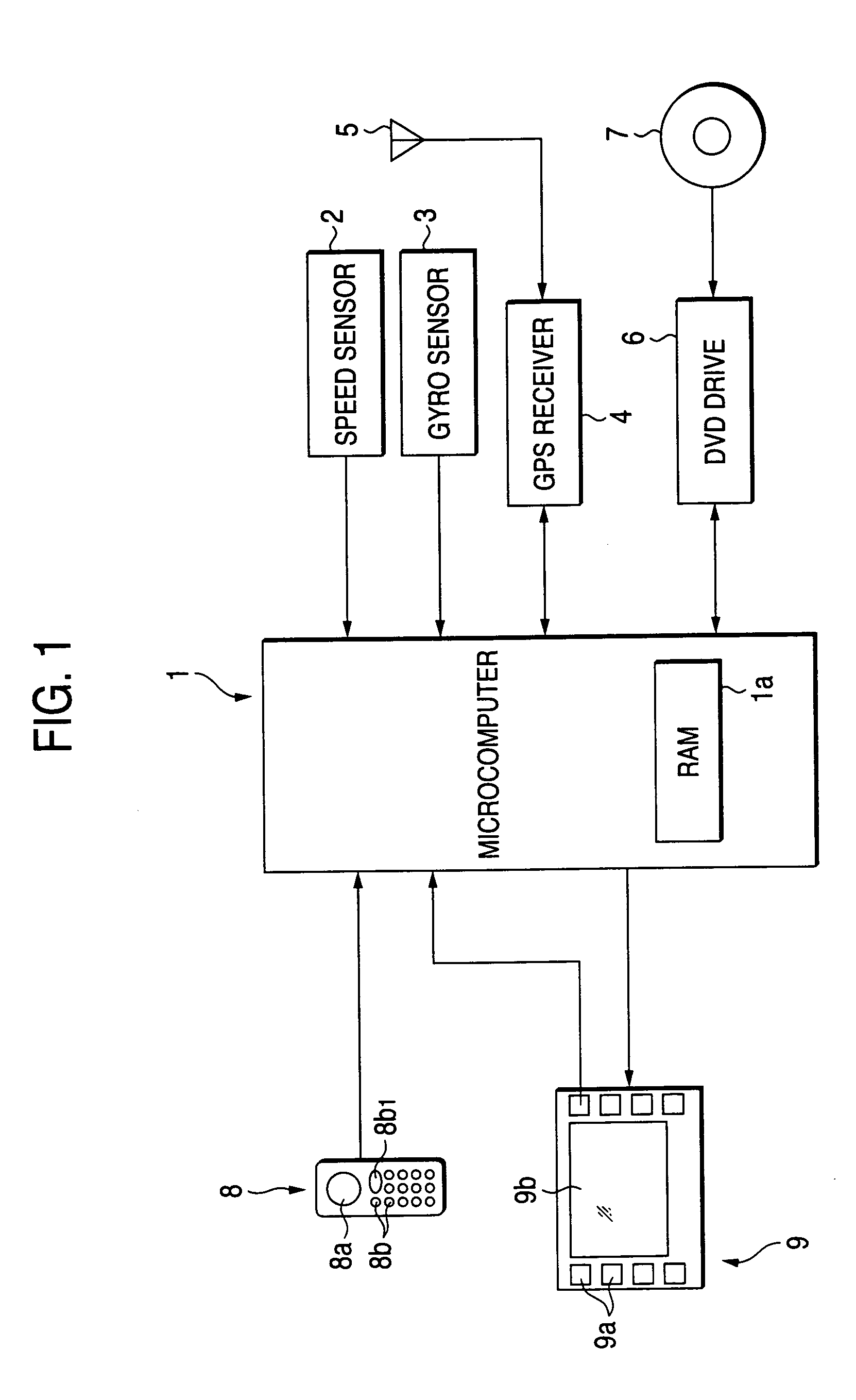
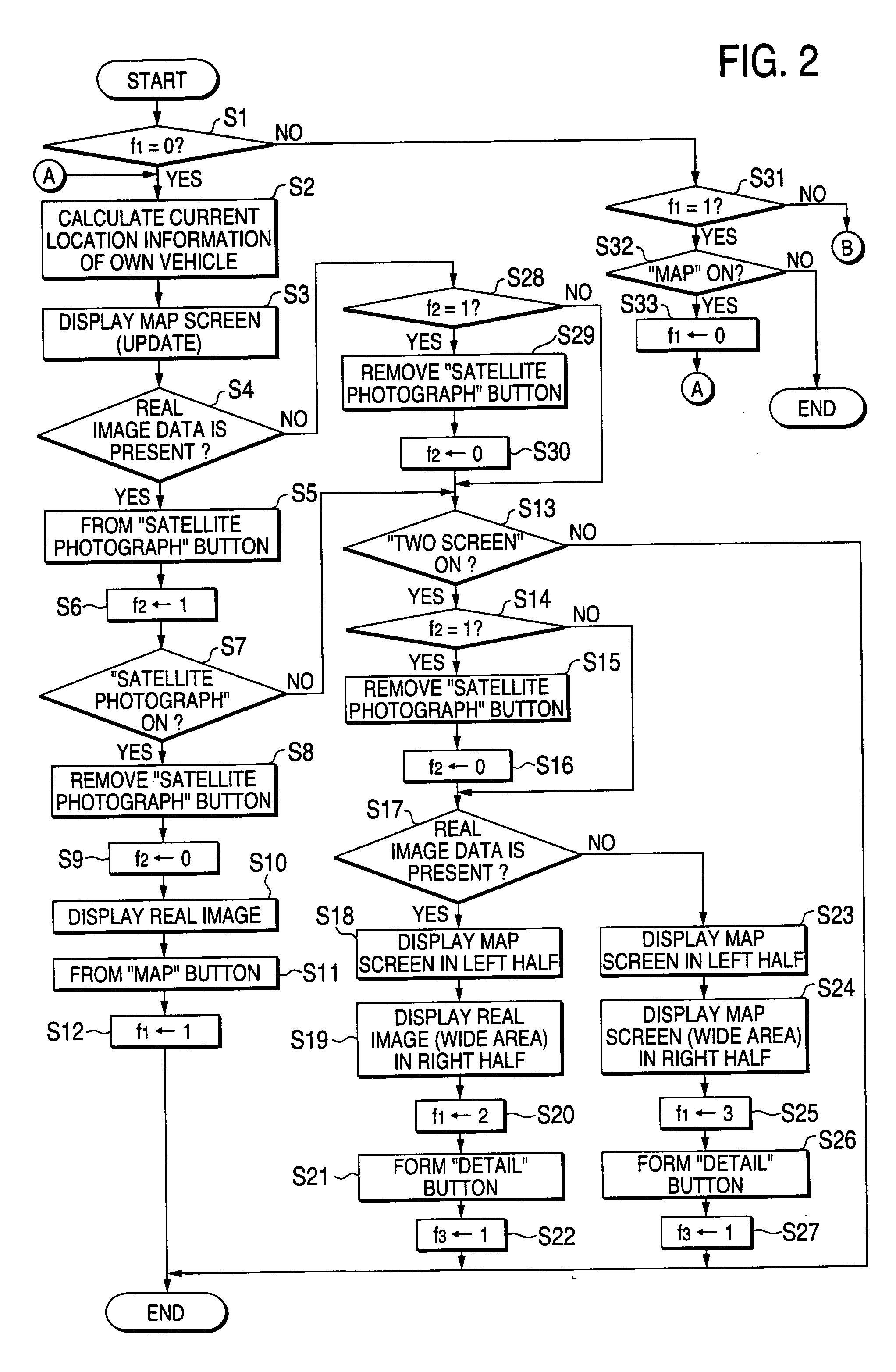
An embodiment of a navigation apparatus according to embodiments of the invention will be explained with reference to the drawings hereinafter. FIG. 1 is a block diagram showing schematically a pertinent portion of a navigation apparatus according to an embodiment (1).

A speed sensor 2 for acquiring information of the covered distance by executing a calculation based on a vehicle speed, and a gyro sensor 3 for acquiring information of the running direction are connected to a microcomputer 1. The microcomputer 1 can determine own vehicle location based on covered distance information and running direction information, both are calculated (self-contained navigation).

A GPS receiver 4 receives a GPS signal transmitted from a satellite via an antenna 5, and is connected to the microcomputer 1. The microcomputer 1 can determine own vehicle location based on the GPS signal (GPS navigation).

Also, a DVD drive 6 that can acquire map data and real image data from a DVD-ROM 7 (other stora...


PUM


Abstract

A map screen is displayed in a left half area of a display panel and an real image such as a satellite photograph depicting a surface of an earth and an aerial photograph is displayed in the remaining right half area thereof based on real image data. The real images on different scales (the image as the wide area display and the image as the detailed display) can be displayed in the right half area on the display panel. A default condition of two-screen display is set to display the real image as the wide area display in the right half-area.

Description

The present disclosure relates to the subject matter contained in Japanese Patent Application No. 2002-137430 filed on May 13, 2002, which is incorporated herein by reference in its entirety. BACKGROUND OF THE INVENTION 1. Field of the Invention The invention relates to a navigation apparatus and, more particularly, a navigation apparatus employing real image data that correspond to images such as a satellite photograph depicting the surface of the earth and an aerial photograph. 2. Description of the Related Art In the related art, a navigation apparatus displays a map on a screen of a display device based on roadmap data recorded in the DVD-ROM, etc., displays own location on the map based on own location data, and guides a user onto routes to a destination. However, in the navigation apparatus in the related art, the map screen to be displayed is formed by using map data. Therefore, there is such a problem that it is difficult to understand own current location and grasp th...

Claims


Application Information

Patent Timeline
IPC IPC(8): G01C21/00G09B29/00G01C21/30G01C21/36G08G1/0969G09B29/10
CPCG01C21/3647G01C21/3667G01C21/3852G01C21/3815G01C21/387
Inventor NAKANO, MASAHIKO
Owner APPLE INC
Why Eureka
Try Eureka