Wireless network assisted GPS system

a gps system and wireless network technology, applied in the field of hybrid gps systems, can solve the problems of increasing the complexity of the problem, requiring extensive processing power, and requiring current geolocation technologies, and achieve the effect of minimizing the power consumption of the mobile unit and processing signals

Active Publication Date: 2005-03-10
NEW JERSEY INSTITUTE OF TECHNOLOGY
View PDF17 Cites 7 Cited by
  • Summary
  • Abstract
  • Description
  • Claims
  • Application Information

AI Technical Summary

Benefits of technology

In the present invention, the positioning of the GPS receiver in a mobile unit is assisted by a wireless network. In particular, the land based wireless network has its own source of GPS satellite data, which can be provided to the GPS receiver to assist the detection of the GPS signals. Furthermore, the position of the mobile unit is calculated by a location application processor in the wireless network, and the GPS receiver does not need to demodulate the ephemeris information from the received GPS signals, but only needs to decode and transmit a set of parameters (pseudo-ranging measurements and satellite ID) to the base station. Thus, the signal processing and power consumption at the mobile unit is minimized. Furthermore, the position location with partial GPS (p-GPS) is possible as the wireless network can help with timing and / or distance information.

Problems solved by technology

This is a result of the facts that, if two receivers are fairly close to each other (compared to the satellites far away in the space), the satellite signals that reach both of the receivers will have traveled through virtually the same slice of atmosphere, and so will have virtually the same errors.
There are, however, several problems in current geolocation technologies.
The power consumption at a GPS receiver is always one of the major concerns in view of the portability of the mobile unit.
The more data processed at the receiver, the more profound the problem.
Having a GPS receiver receive plural signals and then calculate its position requires extensive processing power.
Effective detection of the GPS signals is another issue, since there are numerous satellite signals in space.
Furthermore, sometimes there are not enough satellite signals received at the receiver for position calculation purposes, typically when the signals from one or more satellites are blocked from reaching the receiver.

Method used


Image

  • Wireless network assisted GPS system
  • Wireless network assisted GPS system
  • Wireless network assisted GPS system

Examples


Embodiment Construction

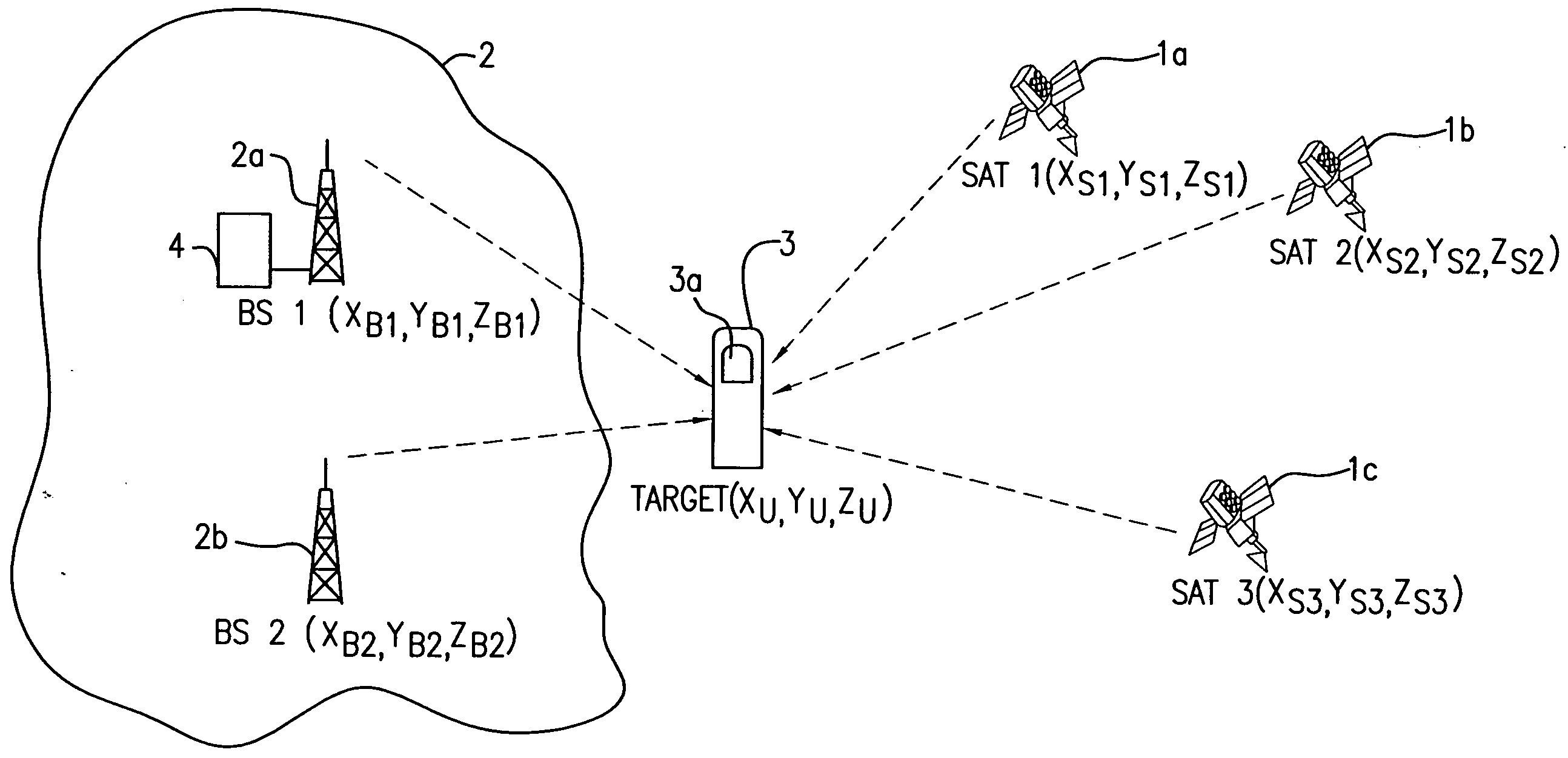
Reference is made to FIG. 1, in which two base stations 2a, 2b of the wireless network 2 and three of the satellites are involved in positioning of the targeted mobile unit 3 which is equipped with a GPS receiver 3a. With the base stations 1a, 1b, the wireless network 2 maintains communication with a plurality of available satellites in space and collects information from these satellites. Like a DGPS reference receiver, the wireless network may include timing errors for each satellite.

The GPS receiver 3a of the mobile unit 3 receives ephemeris data from the three satellites 1a, 1b and 1c, which are not blocked. According to the present invention, however, the ephemeris data does not need to be extensively processed at the mobile unit 3 because of the fact that the wireless network has its own source of GPS satellite data. The mobile unit 3 only needs to decode and transmit a set of GPS parameters (pseudo-ranging measurements and satellite ID) which is needed for the position cal...


PUM


Abstract

A method and apparatus for locating a mobile communications device such as a cell phone includes apparatus for communicating with base stations and apparatus for communicating with satellites. Signals received from satellites and the base stations are combined to provide the necessary information to calculate the location of the mobile communications device.

Description

TECHNICAL FIELD OF THE INVENTION The present invention relates to GPS technologies, and more particularly, to a hybrid GPS system in which positioning of a mobile unit is realized with the assistance of a wireless network. BACKGROUND OF THE INVENTION To determine the position of a mobile unit equipped with a GPS receiver, measurements of distance between the GPS receiver and GPS satellites are made at the receiver. In addition to the distance measurements, the time at which the GPS signals are transmitted from GPS satellites should be deduced from the distance measurements for correcting timing errors in the receiver. Timing errors may be effectively solved by differential GPS (DGPS) technology, in which the correction information of the timing errors is provided from a stationary reference receiver, which uses its known position to calculate timing. This is a result of the facts that, if two receivers are fairly close to each other (compared to the satellites far away in the spa...

Claims


Application Information

Patent Timeline
Patent Type & Authority Applications(United States)
IPC IPC(8): G01S5/02G01S19/09G01S19/46H04W64/00
CPCH04W64/00G01S5/0263
Inventor TEKINAY, SIRINCHOI, WOO-JIN
Owner NEW JERSEY INSTITUTE OF TECHNOLOGY
Why Eureka
Try Eureka