Method and system for delivering virtual reference station data

Active Publication Date: 2005-03-24
TRIMBLE NAVIGATION LTD
View PDF97 Cites 130 Cited by
  • Summary
  • Abstract
  • Description
  • Claims
  • Application Information

AI Technical Summary

Benefits of technology

[0007] Embodiments of the present invention can be used to determine a geographic position with a level of resolution that is comparable with other existing RTK systems. Because the base station need only be known to a lower level of accuracy, it is not necessary to position it at a surveyed position, such as a benchmark. The position of the virtual reference station will be determined to higher level of accuracy by the VRS control center. Additionally, there is no need for a

Problems solved by technology

The errors are due to atmospheric variations which in turn cause changes in the measured path length to the satellites (pseudoranges).
This range limitation has led to the development of more complex enhancements that have superceded the normal RTK operations described above, and in some cases eliminated the need for a base station GPS receiver altogeth

Method used


Image

  • Method and system for delivering virtual reference station data
  • Method and system for delivering virtual reference station data
  • Method and system for delivering virtual reference station data

Examples


Embodiment Construction

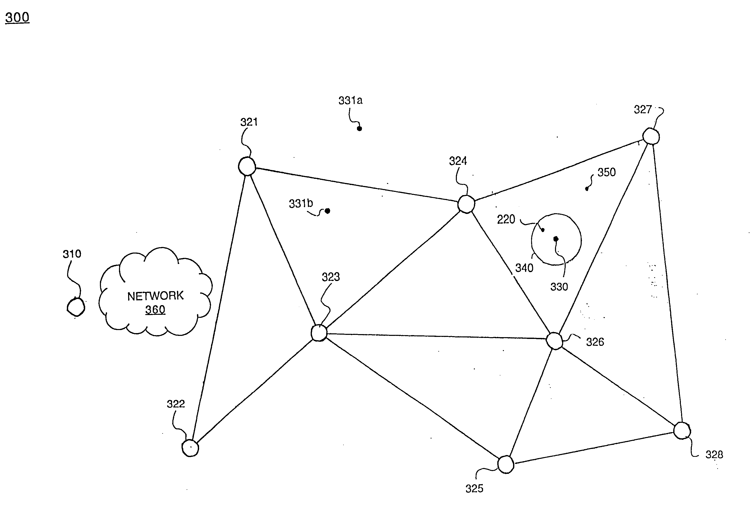
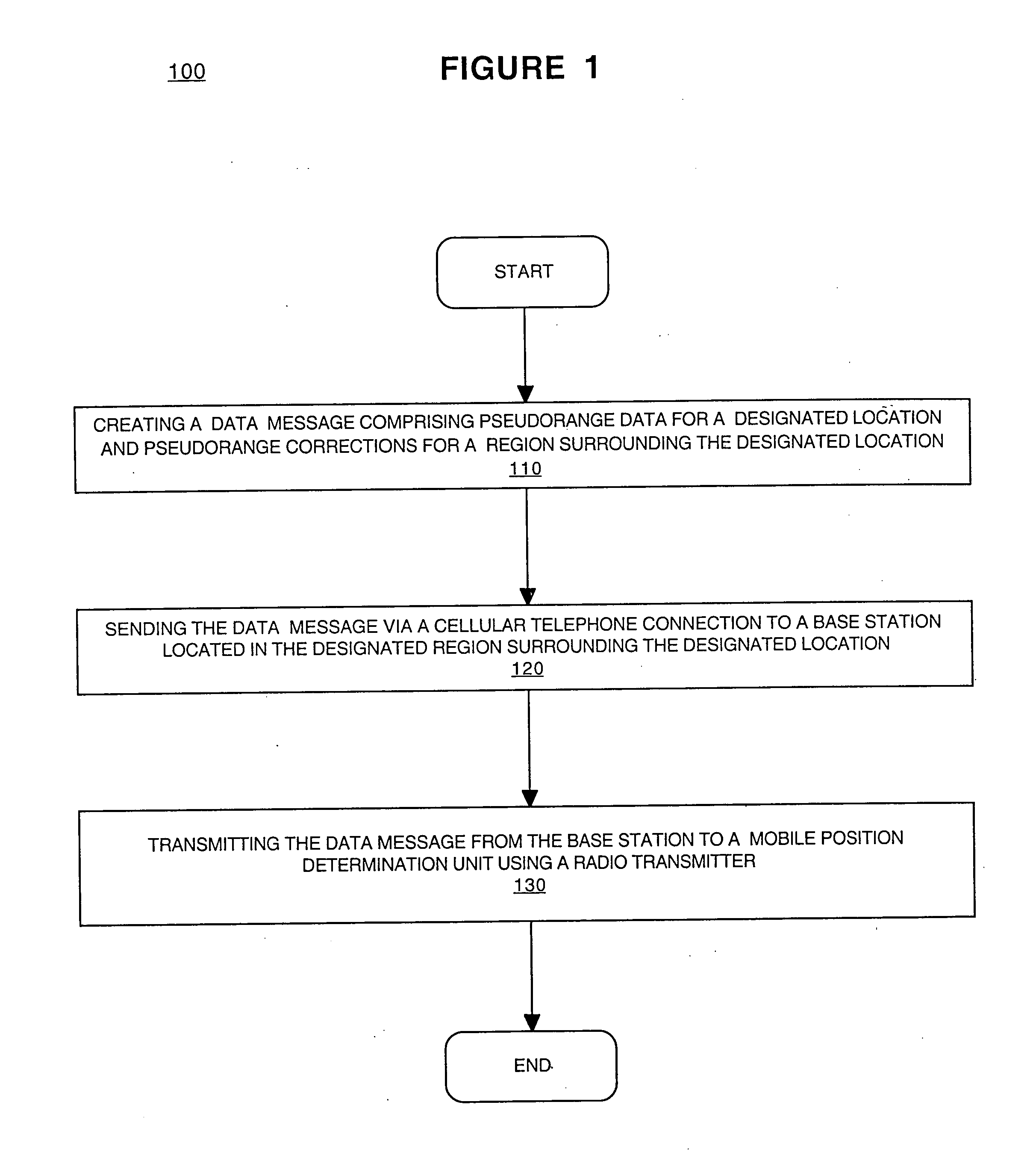
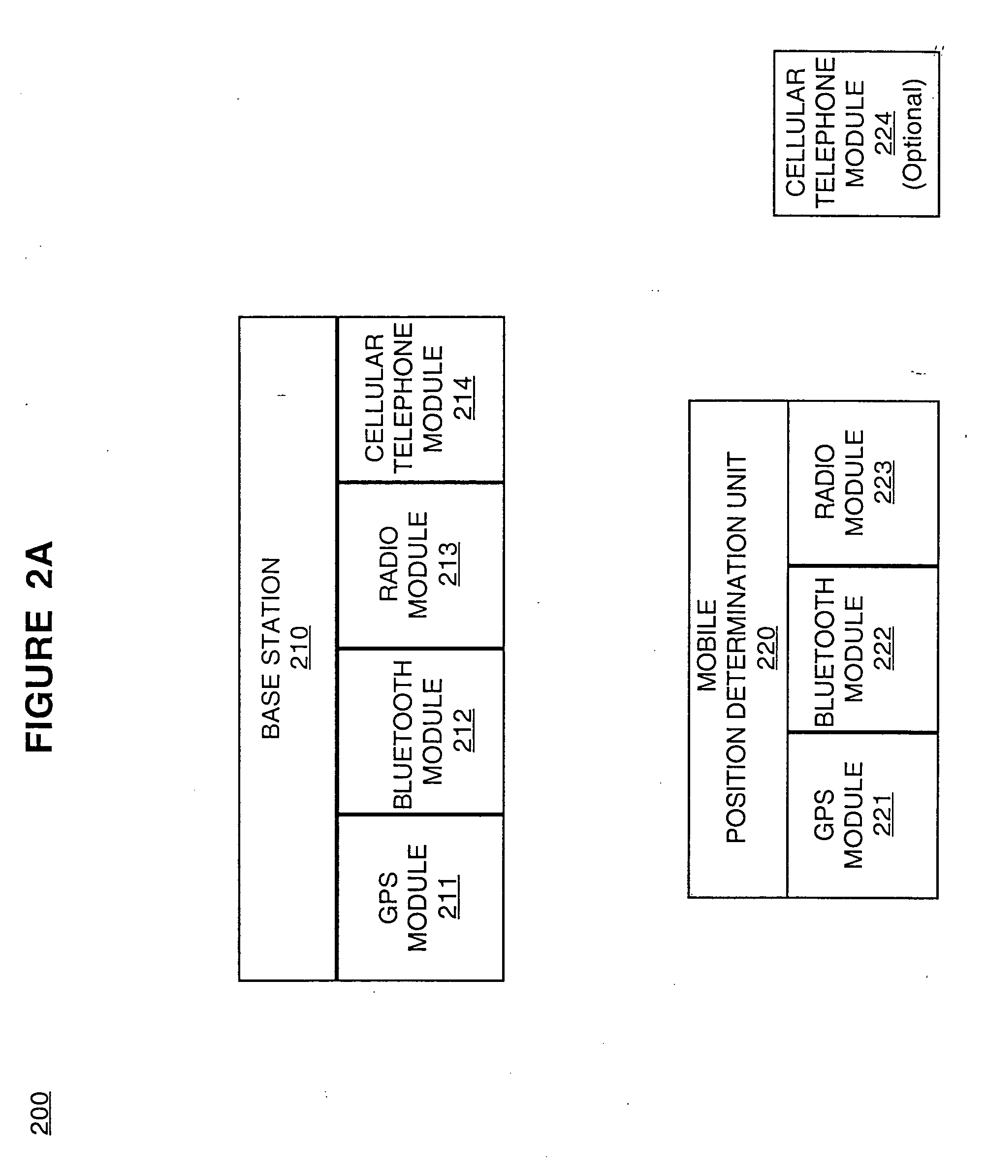
[0014] Reference will now be made in detail to embodiments of the present invention, examples of which are illustrated in the accompanying drawings. While the present invention will be described in conjunction with the following embodiments, it will be understood that they are not intended to limit the present invention to these embodiments alone. On the contrary, the present invention is intended to cover alternatives, modifications, and equivalents which may be included within the spirit and scope of the present invention as defined by the appended claims. Furthermore, in the following detailed description of the present invention, numerous specific details are set forth in order to provide a thorough understanding of the present invention. However, embodiments of the present invention may be practiced without these specific details. In other instances, well-known methods, procedures, components, and circuits have not been described in detail so as not to unnecessarily obscure asp...


PUM


Abstract

The present invention is a method and system for determining a geographic position. In one embodiment, a data message comprising pseudorange data for a designated location and pseudorange corrections for a designated region surrounding the designated location is created. The data message is sent via a cellular telephone connection to a base station located in the designated region. The data message is then transmitted from the base station to a mobile position determination unit using a radio transmitter.

Description

FIELD OF THE INVENTION [0001] The present invention relates to position determining systems. More specifically, the present invention relates to a broadcast network for determining a geographic position. BACKGROUND OF THE INVENTION [0002] Real-Time Kinematics (RTK) refers to a surveying system and method which uses two GPS receivers and a communications link between them to determine a position of one receiver relative to the other receiver. In a typical RTK survey system, a first GPS receiver is located at a known position, often a surveyor's landmark or benchmark, or an otherwise surveyed position, and the pseudorange data it collects is sent to the second GPS receiver, often referred to as a “rover,” via a radio communications link. The rover is used to determine the relative position of desired points according to the needs of the survey effort. Thus there is a radio transmitter associated with the first receiver, called a reference receiver or a base station receiver, and a rad...

Claims


Application Information

Patent Timeline
IPC IPC(8): G01S5/00G01S19/04G01S5/14G01S19/07G01S19/10G01S19/41G01S19/44G01S19/46
CPCG01S5/0063G01S19/41G01S19/07G01S19/071G01S19/43G01S19/073
Inventor O'MEAGHER, BRENT
Owner TRIMBLE NAVIGATION LTD
Why Eureka
Try Eureka