Mobile data collection and processing system and methods

a technology of data collection and processing system, applied in the field of data collection, can solve the problems of not meeting the scale or accuracy required by the census bureau, the approach is not suitable for the 5 m requirement, and the impact of the overall cost of the program is dramatic, so as to achieve the effect of higher speed

Inactive Publication Date: 2005-05-26
HARRIS CORP
View PDF35 Cites 35 Cited by
  • Summary
  • Abstract
  • Description
  • Claims
  • Application Information

AI Technical Summary

Benefits of technology

[0010] In view of the foregoing background, it is therefore an object of the present invention to

Problems solved by technology

Any automation that can be applied to reduce the touched labor costs will have a dramatic impact on the overall cost of the program.
There are several commercial and government programs that are gathering centerline road data

Method used


Image

  • Mobile data collection and processing system and methods
  • Mobile data collection and processing system and methods
  • Mobile data collection and processing system and methods

Examples


Embodiment Construction

[0016] The present invention will now be described more fully hereinafter with reference to the accompanying drawings, in which preferred embodiments of the invention are shown. This invention may, however, be embodied in many different forms and should not be construed as limited to the embodiments set forth herein. Rather, these embodiments are provided so that this disclosure will be thorough and complete, and will fully convey the scope of the invention to those skilled in the art. Like numbers refer to like elements throughout, and prime notation is used to indicate similar elements in alternative embodiments.

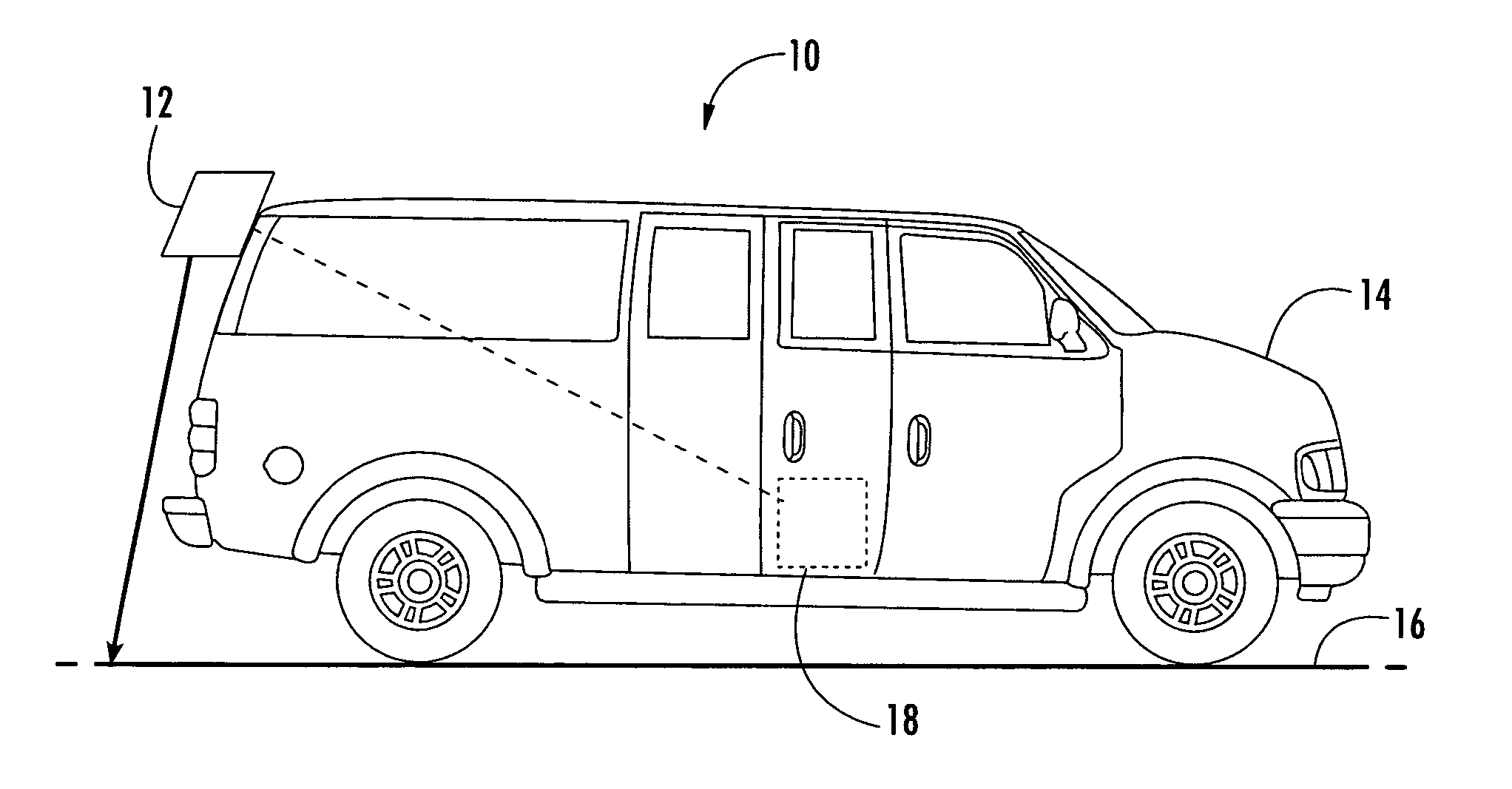
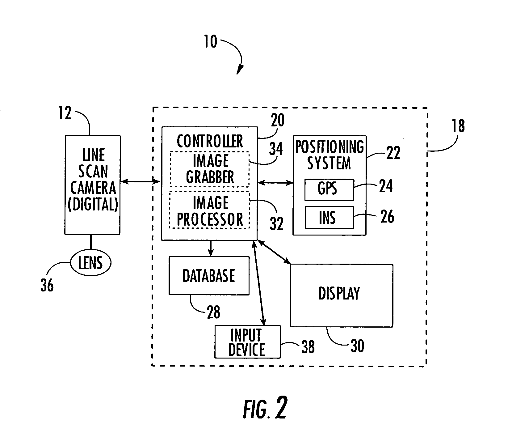
[0017] With reference to FIGS. 1 and 2, a mobile data collection system 10 in accordance with the present invention will be described. The system 10 includes a positioning / navigational system 22 to generate position and time data, and a down-looking line scan camera 12, for mounting on a vehicle 14 to obtain a series of line scan images of a path 16, such as a road. The c...


PUM


Abstract

The mobile data collection system includes a positioning system, such as a Global Positioning System (GPS) receiver and/or an Inertial Navigation System (INS), to generate position and time data. A down looking line scan camera for mounting on a vehicle, obtains a series of line scan images of a path, such as a road. A data collection controller is connected to the positioning system and the line scan camera to associate the line scan images with the corresponding position and time data. A database stores the line scan images and associated corresponding position and time data. An image processor identifies and marks features in the line scan images.

Description

FIELD OF THE INVENTION [0001] The present invention relates to the field of data collection, and, more particularly, to mobile mapping systems and road database management and related methods. BACKGROUND OF THE INVENTION [0002] Accurate position of roads is useful in many commercial and government applications ranging from real time vehicle navigation systems to the definition of boundaries (congressional, municipal, voting districts). [0003] The MAF, or Master Address File, is designed to be a complete and current list of all addresses and locations where people live or work, covering an estimated 115 million residences, as well as 60 million businesses and other structures in the United States. TIGER®, or Topologically Integrated Geographic Encoding and Referencing data is a digital database that identifies the type, location and name of streets, rivers, railroads and other geographic features, and geospatially defines their relationships to each other, to the MAF addresses, and t...

Claims


Application Information

Patent Timeline
IPC IPC(8): G01C7/04G01C11/02G06F19/00G06T7/00
CPCG01C7/04G06T7/004G01C11/025G06T7/70
Inventor BELL, DAVID MONROECULP, TIMOTHY RAYMONDDALY, JOHN BRYANHATTERMANN, MICHAEL
Owner HARRIS CORP
Why Eureka
Try Eureka