System and method for creating accurate topographical maps using low-drift DGPS

a topographical map and low-drift technology, applied in the field of topographical maps, can solve the problems of limiting the area over which an rtk system may provide the accuracy desired to within a relatively small radius of a surveyed base station, and the accuracy of correction factors that are less accurate than desired, so as to achieve the effect of low position drift ra

Inactive Publication Date: 2005-10-13
DEERE & CO
View PDF6 Cites 11 Cited by
  • Summary
  • Abstract
  • Description
  • Claims
  • Application Information

AI Technical Summary

Benefits of technology

[0006] Accordingly, the present invention provides a method for acquiring elevation data for an area, which may be used for creating accurate topographical maps. The method of the present invention uses a GPS, such as a wide area differentially corrected GPS with low position drift rate, or the like, to map ground elevations. The method includes navigating a plurality of substantially parallel tracks traversing an area generally along a first axis (e.g., by driving back and forth over the area) while periodically recording position, altitude (uncorrected elevation), and time using the GPS. At least one cross track is navigated traversing the area generally along a second axis intersecting the first axis so that the cross track intersects the tracks, while periodically recording position, altitude, and time using the GPS. The recorded data i...

Problems solved by technology

Because of atmospheric interference with satellite signals received by a GPS receiver, such as interference from the ionosphere, troposphere, cloud cover, weather, and the like, elevation data measured by a GPS receiver may tend to drift over time.
The range of the equipment used to transmit and receive signals over the radio links, as well as differing atmospheric conditions in the vicinity of the base station, which may make correction factor...

Method used


Image

  • System and method for creating accurate topographical maps using low-drift DGPS
  • System and method for creating accurate topographical maps using low-drift DGPS
  • System and method for creating accurate topographical maps using low-drift DGPS

Examples


Embodiment Construction

[0015] Reference will now be made in detail to the presently preferred embodiments of the invention, examples of which are illustrated in the accompanying drawings.

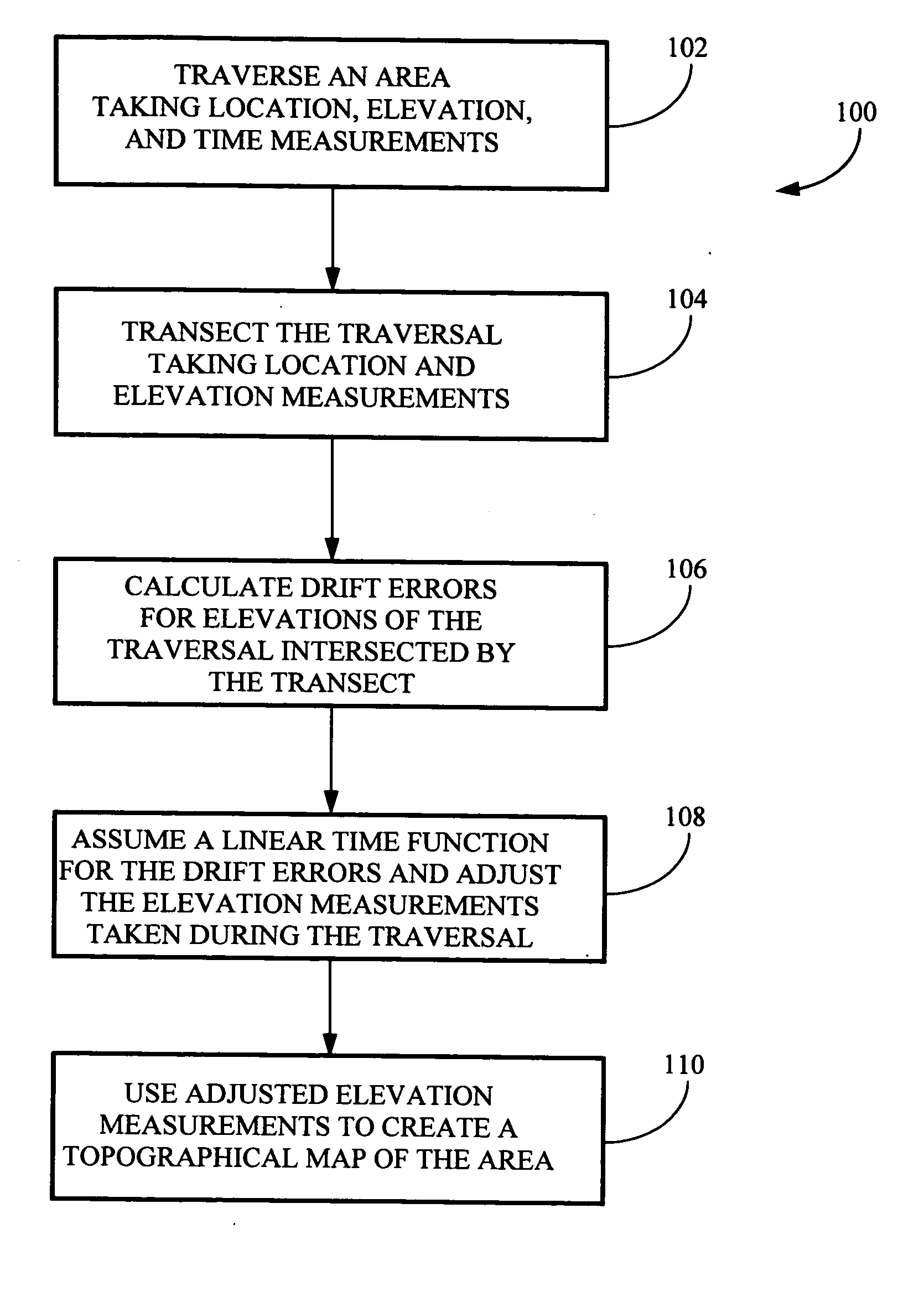
[0016] Referring generally to FIGS. 1 through 3, a method for acquiring elevation data for an area suitable for producing accurate topographical maps in accordance with an exemplary embodiment of the present invention is described. Mapping ground elevations for a series of locations in an area, such as for creating a topographical map of the area, may be accomplished by traversing the area and periodically measuring positional and elevation data for the various locations in the area. Measuring the position and elevation of each location is typically accomplished using a GPS receiver, such as a wide area differentially corrected GPS receiver, or the like. When creating a topographical map of an area for slope sensitive applications, such as for analyzing water flow, drainage for agricultural fields, and the like, relative...


PUM


Abstract

The present invention is directed to a method for acquiring elevation data for an area. The method includes using a GPS receiver to map ground elevations while driving back and forth over an area and periodically recording position, elevation, and time. Then, at least one track is made across the parallel tracks so that the cross track intersects the parallel tracks. The data obtained is processed and elevation data from the cross track is used to adjust elevation data for the parallel tracks, compensating for elevation drift in measurements recorded by the GPS receiver. The adjusted data for the entire area is processed using the method of the present invention to obtain an elevation map for the area.

Description

FIELD OF THE INVENTION [0001] The present invention generally relates to the field of topographical mapping, and particularly to a system and method for creating accurate topographical maps using low-drift differentially corrected global positioning systems (DGPS). BACKGROUND OF THE INVENTION [0002] Mapping ground elevations for a series of locations in an area, such as for creating a topographical map of the area, may be accomplished by traversing the area and periodically measuring positional and elevation data for various locations in the area. Measuring the position and elevation of each location is typically accomplished using a global positioning system (GPS) receiver, such as a wide area differentially corrected global positioning system (WADGPS) receiver, or the like. When creating a topographical map of an area for slope sensitive applications, such as for analyzing water flow, drainage for agricultural fields, and the like, relative elevation accuracy is required. For exam...

Claims


Application Information

Patent Timeline
IPC IPC(8): G01C15/00G01S19/27
CPCG01C15/00
Inventor PICKETT, TERENCENELSON, FREDERICKHENDRICKSON, LARRY
Owner DEERE & CO
Why Eureka
Try Eureka