
GNSS navigation solution integrity in non-controlled environments

a technology of non-controlled environments and navigation solutions, applied in traffic control systems, navigation instruments, instruments, etc., can solve problems such as measurement source errors

Inactive Publication Date: 2006-03-02
GMV AEROSPACE & DEFENCE
View PDF12 Cites 61 Cited by
  • Summary
  • Abstract
  • Description
  • Claims
  • Application Information

AI Technical Summary

Benefits of technology

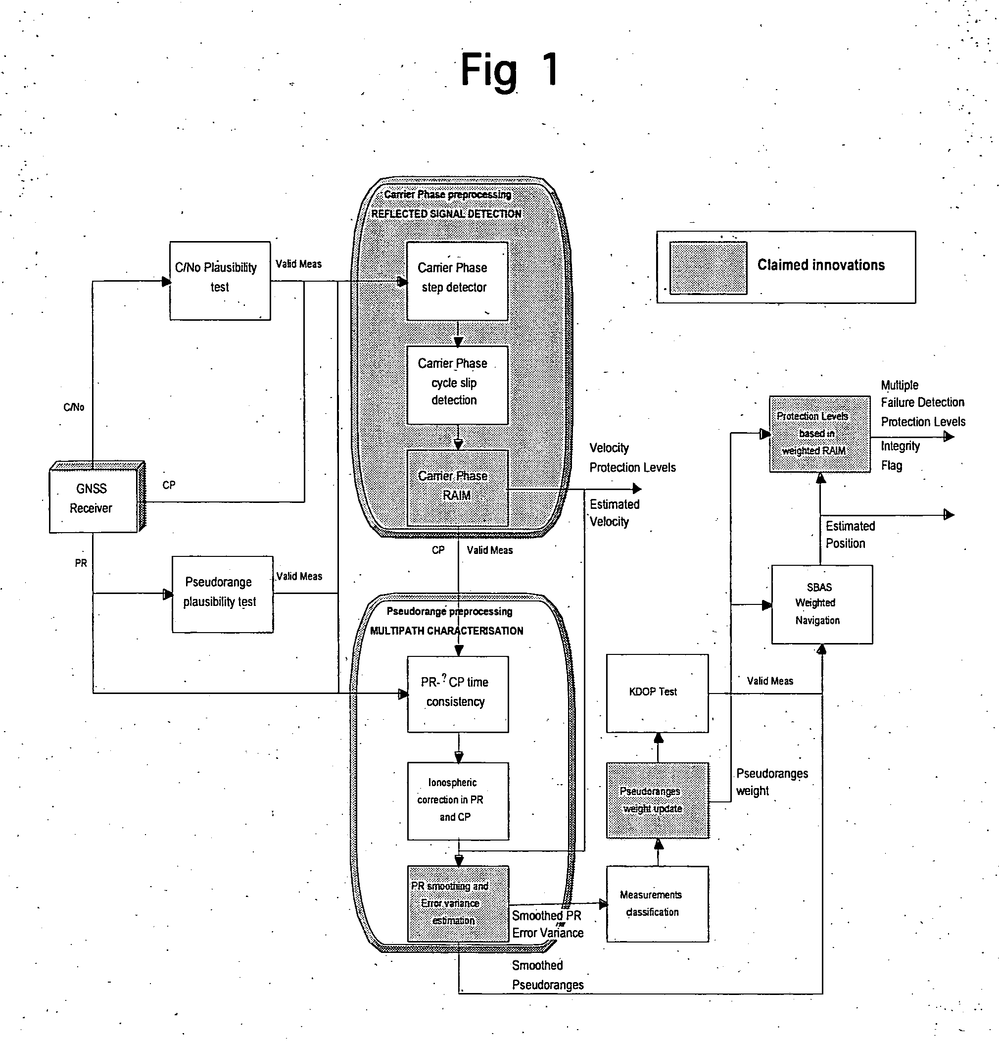
[0040] Our innovation takes advantage of the behaviour of the different types of multipath (composed direct plus reflected signal and only reflected signal) in presence of the receiver dynamics to develop efficient methods to reject degraded measurements and to characterise the measurements noise with σi,multipath2 for navigation. The receiver dynamics ...

Problems solved by technology

The remaining sources of errors in the measurements will be the local effects, usually dominated by the multipath.

Method used


Image

  • GNSS navigation solution integrity in non-controlled environments
  • GNSS navigation solution integrity in non-controlled environments
  • GNSS navigation solution integrity in non-controlled environments

Examples


Embodiment Construction

[0054] Reference will now be made in detail to the embodiment of the invention, a method for guaranteeing the integrity of the navigation solution in non-controlled environments based on the service integrity included in a GNSS Signal in Space (from SBAS system today and GBAS, Galileo and GPS-III in the future). While the invention will be described in conjunction with the preferred embodiments, it will be understood that they are not intended to limit the invention to these embodiments.

[0055] The objective of the proposed methods is the computation of the navigation solution (position, velocity and / or time) error bounds (also known as Protection levels in the civil aviation world) that guarantees the required level of integrity, i.e. that ensures that the probability of the error being larger than the mentioned error bound is below certain probability, and also the computation of a flag of validity of the navigation and integrity outputs.

[0056] Method ensures the validity of the ...


PUM


Abstract

The present invention consists of a method to ensure the integrity of the navigation solution even when the user is in a non controlled environment as it is the case of urban and road applications. The method requires the existence of a Signal In Space with guaranteed integrity as the one today provided by SBAS systems or from GBAS, Galileo or GPS-III in the future. The invention covers the algorithms to detect and isolate errors present in non controlled environments such as multipath and compute resulting position error bounds with the required level of integrity. This invention substantially increases the field of application of satellite navigation systems with associated integrity to the so-called liability critical applications.

Description

REFERENCES CITED [0001] [RD.1] Minimum Operational Performance Standards for Global Positioning System / Wide Area Augmentation System Airborne Equipment, RTCA / DO-229C, 28 / 11 / 2001 [0002] [RD.2] Y. C. Lee, K. L. Van Dyke, Analysis Performed in Support of the Ad-Hoc Working Group of RTCA SC-159 on RAIM / FDE Issues, in Proc. National Technical Meeting ION, ION NTM 2002, January 2002 [0003] [RD.3] Weighted RAIM for Precision Approach, T. Walter, P. Enge, ION GPS, 1995 [0004] [RD.4] Navstar GPS User Equipment Introduction, 1996 [0005] [RD.5] Integrity Measure for Assisted GPS Based on Weighted Dilution of Precision, H. Sairo, J. Syrjärinne, J. Lepäkoski and J. Takala, ION GPS 2002, September 2002 [0006] [RD.6] Solution of the Two Failure GPS RAIM Problem Under worst Case Bias Conditions: Parity Space Approach, R. Grover Brown, NAVIGATION, Vol. 44, No. 4, Winter 1997-98. FIELD OF THE INVENTION [0007] The present invention relates to methods and algorithms for implementing in future Global Na...

Claims


Application Information

Patent Timeline
IPC IPC(8): G01C21/36
CPCG01S19/20G01S19/42G01S19/39G01S19/396
Inventor LOPEZ, NESTOR ZARRAOAMARTIN PIEDELOBO, JUAN RAMONLOPEZ, MANUEL TOLEDOSCHORTMANN, JOAQUIN COSMEN
Owner GMV AEROSPACE & DEFENCE
Learn More