
Method for data regulariization for shot domain processing

a data and shot domain technology, applied in the field of geophysical prospecting, can solve the problems of difficult to achieve in common industry practice, inability to meet the needs of seismic data processing, and inability to provide data suitable or optimal for either of the above processing algorithms

Active Publication Date: 2006-05-11
EXXONMOBIL UPSTREAM RES CO
View PDF16 Cites 65 Cited by
  • Summary
  • Abstract
  • Description
  • Claims
  • Application Information

AI Technical Summary

Benefits of technology

[0009] The present invention is a method for taking input seismic data that have been acquired on a non-uniform coarsely sampled grid that may include only a limited range of source-to-receiver azimuths and transforming those data into an equivalent set of data on a finely sampled regular and dense grid including all source-to-receiver azimuths. The new data are equivalent in the sense th

Problems solved by technology

Ideally for many seismic processing and interpretation objectives, the source and receiver locations would lie on a uniformly and densely sampled grid but this is difficult to achieve in common industry practice for many reasons including surface obstructions, currents, cable feathering, and acquisition cost.
These desired data are often obscured by undesired multiple reflections of seismic energy.
Current marine acquisition geometries do not provide the data suitable or optimal for either one of the above processing algorithms.
Spatial aliasing, i.e., insufficient (less than two points per wavelength) sampling of data along a space axis, is a universal difficulty affecting all existing methods.
Although existing seismic data interpolation methods can interpolate data “beyond aliasing” under certain assumptions, their performance degrades as shot and receiver sampling become coarser and aliasing becomes more severe.
Given that typical shot intervals in marine acquisition are hundreds of meters in the crossline (transverse to the boat movement) direction, there is currently no effective way of interpolating data to make it suitable for 3D SRME, which requires a data spacing of roughly 10-20 meters.
Similarly, there is no known method capable of reconstructing the 360-degree receiver coverage that would be ideal for SRWEM.
However, this is not easily achievable in practice since subsurface properties are typically not known with sufficient accuracy.
While migration-demigration would provide very accurate results even in the most complex geologic settings, the cost incurred would be prohibitive given computer resources currently available in the industry.
The key issue in the case of the shot record interpolation problem is that the output shot records comprise all possible azimuths and offsets, with nearly continuous azimuth angle variation between 0 and 360 degrees.
If existing technology were applied, it would have been necessary to perform thousands of AMO runs to reconstruct all possible azimuths and offsets that may be present in a shot record, once again leading to a prohibitively expensive approach.
The one-step shot continuation method proposed by Stolt can be very costly if applied to a conventional marine survey in order to reconstruct densely spaced shot records with dense receiver coverage, as required, for example, for 3D SRME.

Method used


Image

  • Method for data regulariization for shot domain processing
  • Method for data regulariization for shot domain processing
  • Method for data regulariization for shot domain processing

Examples


examples

1. Synthetic Data Example

[0060] The goal of this synthetic test was to reconstruct a shot in a position where it had not been originally “acquired” (modeled, since this is a synthetic example) and to compare it to a shot at the same position, modeled separately. Good agreement between the two results would validate the reconstruction method. In this example, a typical marine survey with 10 streamers and 2 sources was modeled. FIG. 7 illustrates the geologic model, which consists of the free surface 71, water bottom with cross-line dip 72, and one subsurface reflector 73 with both in-line and cross-line dips. Typical values were assigned for P-wave and S-wave velocities and for density in the different regions of the model. The reconstruction process described above was applied to synthesize a shot positioned at 75 between two of the original sail lines(not shown), and the results are shown in FIG. 8. A shot at exactly the same location with exactly the same receiver coverage 74 was...


PUM


Abstract

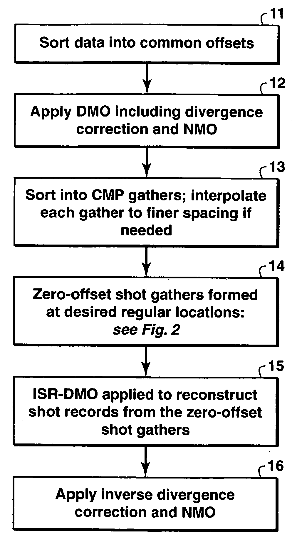
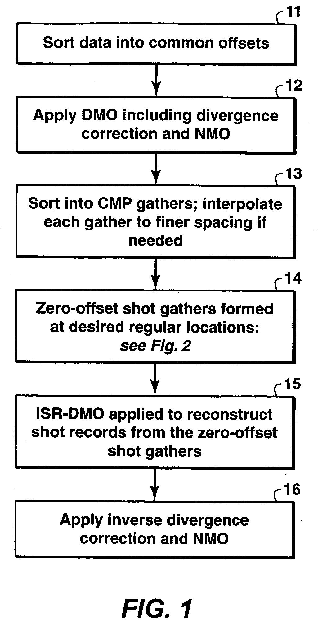
Method for interpolating aliased seismic data to generate shot records at regular shot points. The method involves sorting the data into common offsets to obtain the finer sampling in the common-offset domain, then using DMO to transform the data to zero offset to eliminate azimuth and offset variations, from which densely sampled shot records are reconstructed by an efficient Log-Stretch Inverse Shot Record DMO. The method has ready application to techniques that benefit from input data that are regularly and densely sampled, such as 3-D surface related multiple elimination and shot record wave equation migration.

Description

[0001] This application claims the benefit of U.S. Provisional Patent Application No. 60 / 625,897 filed on Nov. 8, 2004.FIELD OF THE INVENTION [0002] This invention relates to the field of geophysical prospecting and, more particularly, to seismic data processing. Specifically, the invention is a method for regularization of seismic data for purposes that include multiple suppression and shot record migration. BACKGROUND OF THE INVENTION [0003] In seismic data acquisition, the seismic source is typically positioned at a selected shot location, and the seismic reflections of the shot are detected (the “shot record”) by receivers also located at selected locations. Then, the source and receivers are moved to different locations and the process repeated, and in this manner a seismic survey is taken of a selected subterranean region. Ideally for many seismic processing and interpretation objectives, the source and receiver locations would lie on a uniformly and densely sampled grid but t...

Claims


Application Information

Patent Timeline
IPC IPC(8): G01V1/28
CPCG01V1/28G01V2210/57
Inventor ANDERSON, JOHN E.BAUMSTEIN, ANATOLY I.HADIDI, MOHAMED T.
Owner EXXONMOBIL UPSTREAM RES CO
Learn More