Vertical situation display terrain/waypoint swath, range to target speed, and blended airplane reference

a technology of vertical situation and waypoint swath, which is applied in surveying, navigation, instruments, etc., can solve the problems of requiring interpretation, affecting the accuracy of contour maps, and unable to provide general awareness of surrounding terrain height, so as to avoid collisions with terrain and achieve more efficient and safe landing approaches.

Inactive Publication Date: 2006-11-09
THE BOEING CO
View PDF7 Cites 56 Cited by
  • Summary
  • Abstract
  • Description
  • Claims
  • Application Information

AI Technical Summary

Benefits of technology

[0013] The above-described display of the invention provides flight information to assist the pilot in avoiding terrain collisions or making more efficient and safe landing approaches. The displays provide this information in a format that is relatively intuitive for the pilot to understand without substantial analysis, interpretation, false alarms, or unnecessary distraction from other duties, and conforms to standard graphical depictions used on approach charts and other places in the flight deck, thereby allowing the pilot to make any necessary adjustments to the speed and direction of the aircraft relatively quickly and precisely

Problems solved by technology

Due to the display shading limitations and the nature of a top down view display, the contour map can only provide a general awareness of the surrounding terrain height.
Even with these vertical situational awareness features on the navigation display, the information still requires some interpretation, and approach and landing accidents continue to occur.
The pilot may not be able to perform an optimal vertical maneuver if the pilot is not aware of the height of the surrounding terrain.
However, the display changes with slight adjustments to the direction of the aircraft, making it appear “noisy”.
Also, navigational instruments for determining the exact position of an aircraft usually have some degree of error.
For example, if the aircraft's automated navigational equipment is only accurate to within 10 nautical miles of the exact location of the aircraft, and the topography display only shows a “line” of topography directly in front of where the aircraft instruments indicate the aircraft is located, the topography display will be not be accurate as to the topography directly in front of the aircraft if the aircraft's exact position is actually 9.5 nautical miles from the location indicated by the navigation equipment.
When the aircraft is not on this ideal path, the flight deck instruments do not indicate the degree of correction required to return the aircraft to the correct descent path.
If the pilot under- or overcorrects the descent angle and cannot position the aircraft onto a suitable landing approach path in a short period of time, the pilot may have to make a decision to abort the landing, circle, and begin another landing approach.
These calculations and estimations may not be very precise and may distract the pilot from performing other duties connected with flying the aircraft and maintaining an accurate mental picture of the situation.
If the reference aircraft symbol on a vertical profile display (VPD) is fixed near the bottom of the display and the aircraft is in a descent, the resolution of the display for that range of altitudes will be insufficient to provide the pilot with any increased awareness of the terrain the aircraft is approaching.
Similarly if the aircraft symbol is fixed at the top of the display and the aircraft is climbing, resolution will be insufficient to increase the pilot's awareness of the airplane's relationship with the terrain ahead.

Method used


Image

  • Vertical situation display terrain/waypoint swath, range to target speed, and blended airplane reference
  • Vertical situation display terrain/waypoint swath, range to target speed, and blended airplane reference
  • Vertical situation display terrain/waypoint swath, range to target speed, and blended airplane reference

Examples


Embodiment Construction

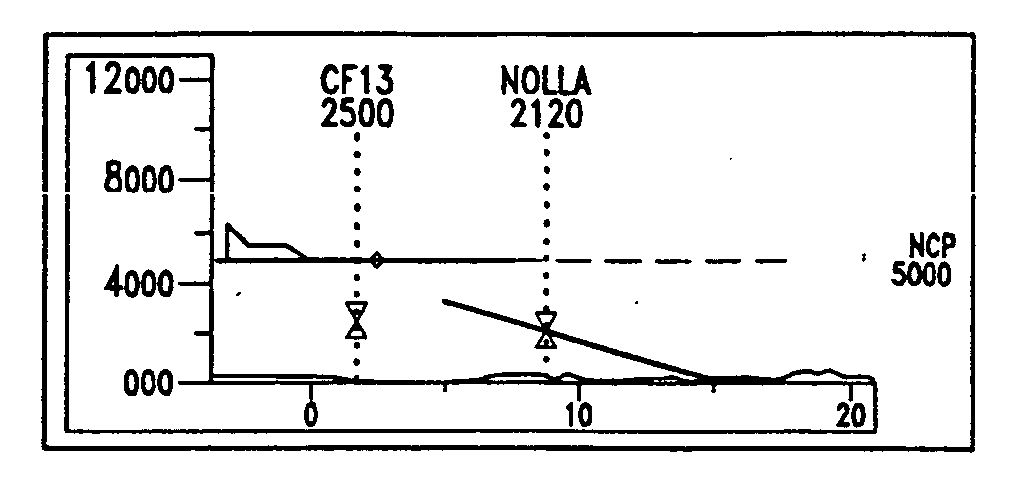
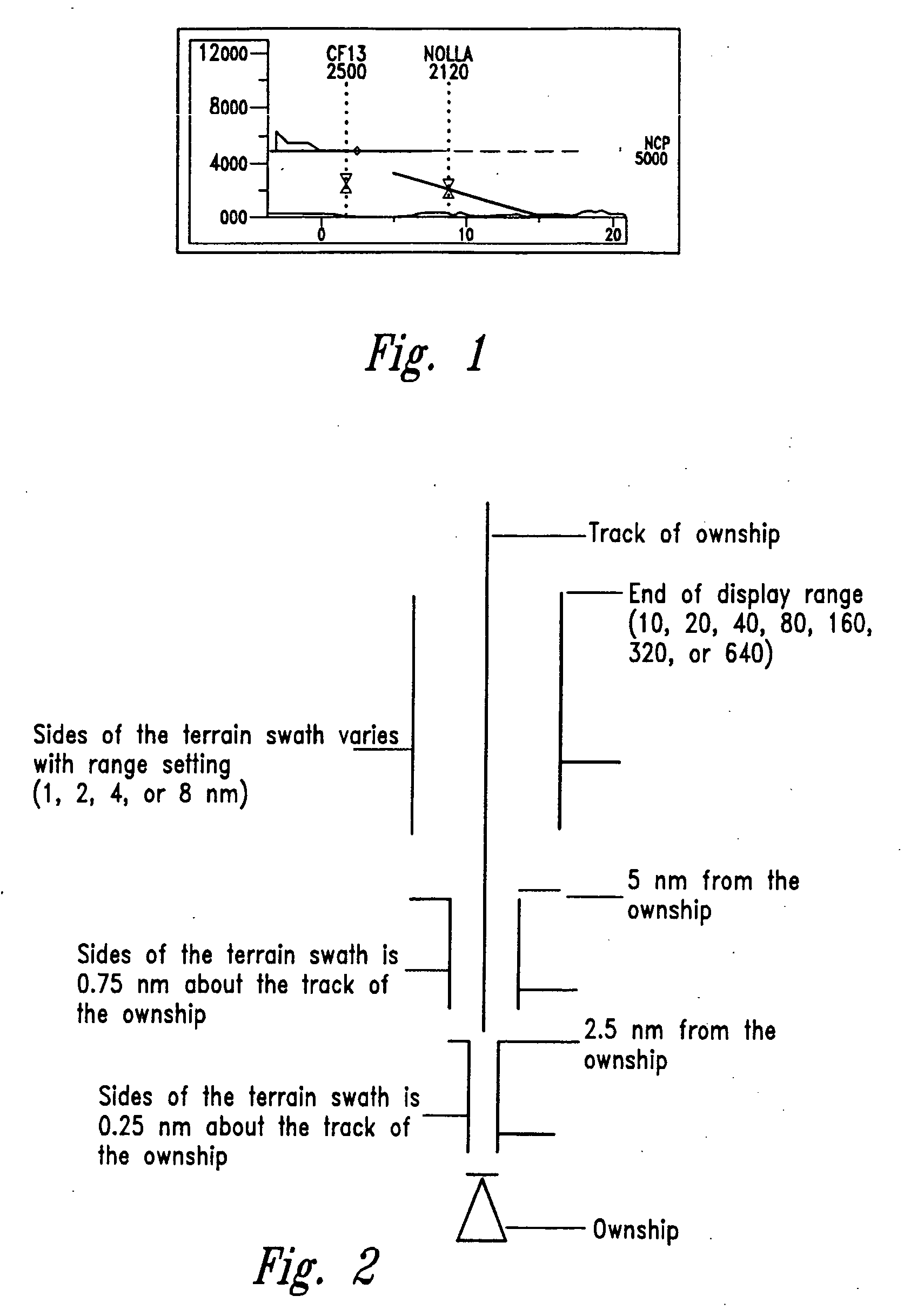
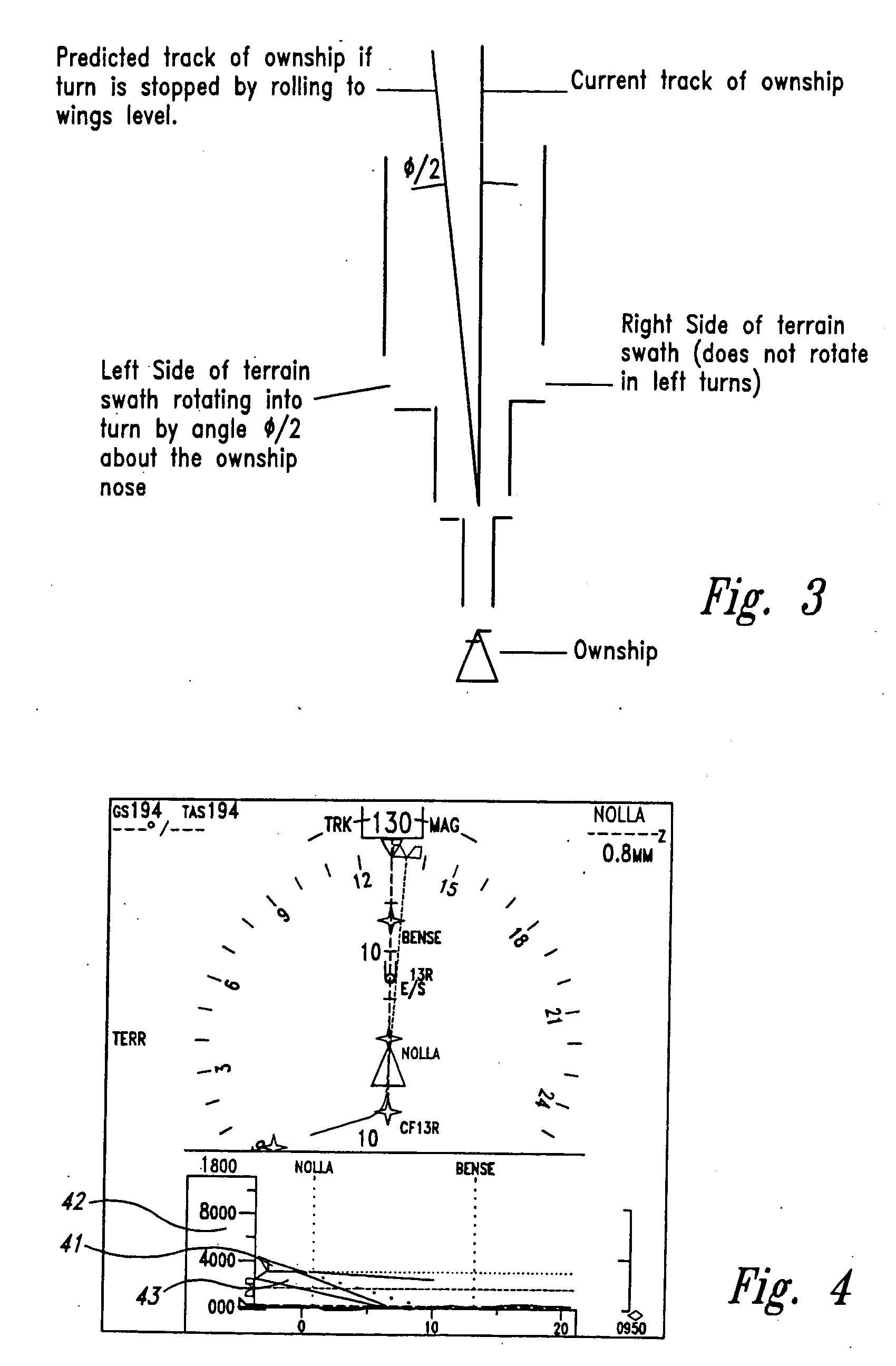
[0023] The flight information display of the first aspect of the invention specifies a region in front of the aircraft to show terrain, waypoints and runways, on a vertical profile display. The source of the information to generate the profile of the terrain display may come from, but is not limited to, an on-board computer having a database of topographical information or a ground mapping radar. A Vertical Profile Display (VPD), provides a view of the vertical plane along the track of the aircraft (see FIG. 1), and may also display other information such as data on aircraft performance or target altitude information.

[0024] The terrain depicted on the display is the highest terrain that is within a specified swath of terrain along the direction of the airplane's track. Specifically, the terrain value depicted at any given distance from the airplane symbol is the maximum terrain height along an arc at that given distance centered on the airplane and bounded by the edges of the swath...


PUM


Abstract

A flight information display for the flight deck of an aircraft showing a pictorial side view of the flight path or the area directly in front of the aircraft area having a selected distance of at least 0.5 nautical miles, comprising (a) a pictorial representation to scale of the profile of the highest elevations of a swath of terrain along said path or area, (b) an icon positioned on the left or right side of the display representing the aircraft, the altitude of which is to scale with the height of the terrain, and (c) an altitude reference scale; wherein the width of the swath is at least 0.1 nautical miles and no greater than the distance of the minimum accuracy of the means for determining the aircraft's location.

Description

CROSS-REFERENCE TO RELATED APPLICATION [0001] This application is a divisional of U.S. patent application Ser. No. 10 / 019,459 filed Dec. 26, 2001, which is a U.S. national phase of PCT application PCT / US00 / 20451, which claims priority from U.S. provisional patent application Ser. No. 60 / 146,489, filed Jul. 30, 1999, titled Vertical Situation Display Terrain / Waypoint Swath, Range to Target Speed, and Blended Airplane Reference.BACKGROUND OF THE INVENTION [0002] In modern flight decks, the primary flight information display (PFD) and the navigation display (ND) are the key displays available for providing situational awareness to the pilot. Although the primary flight information display provides aircraft attitude and performance information through the attitude direction indicator (ADI), airspeed tape, heading and track indicator, and vertical speed indicator (VSI), the performance information is not shown in relation to the aircraft's surroundings. The navigation display provides fa...

Claims


Application Information

Patent Timeline
Patent Type & Authority Applications(United States)
IPC IPC(8): G01C21/00
CPCG01C23/00
Inventor CHEN, SHERWIN S.FOX, JULIANNE M.WIEDEMANN, JOHN
Owner THE BOEING CO
Why Eureka
Try Eureka