Methods and systems for generating en-route visible terrain displays

Active Publication Date: 2007-06-28
THE BOEING CO
View PDF21 Cites 20 Cited by
  • Summary
  • Abstract
  • Description
  • Claims
  • Application Information

AI Technical Summary

Benefits of technology

[0004]In one embodiment, a method for displaying an en-route visible terrain display for an aircraft includes representing each pixel of a terrain display using a geographical location and an elevation above the location, each pixel further represented using at least one of a color value and a grayscale value, receiving a minimum elevation value, setting the at least one of a color value and a grayscale valu

Problems solved by technology
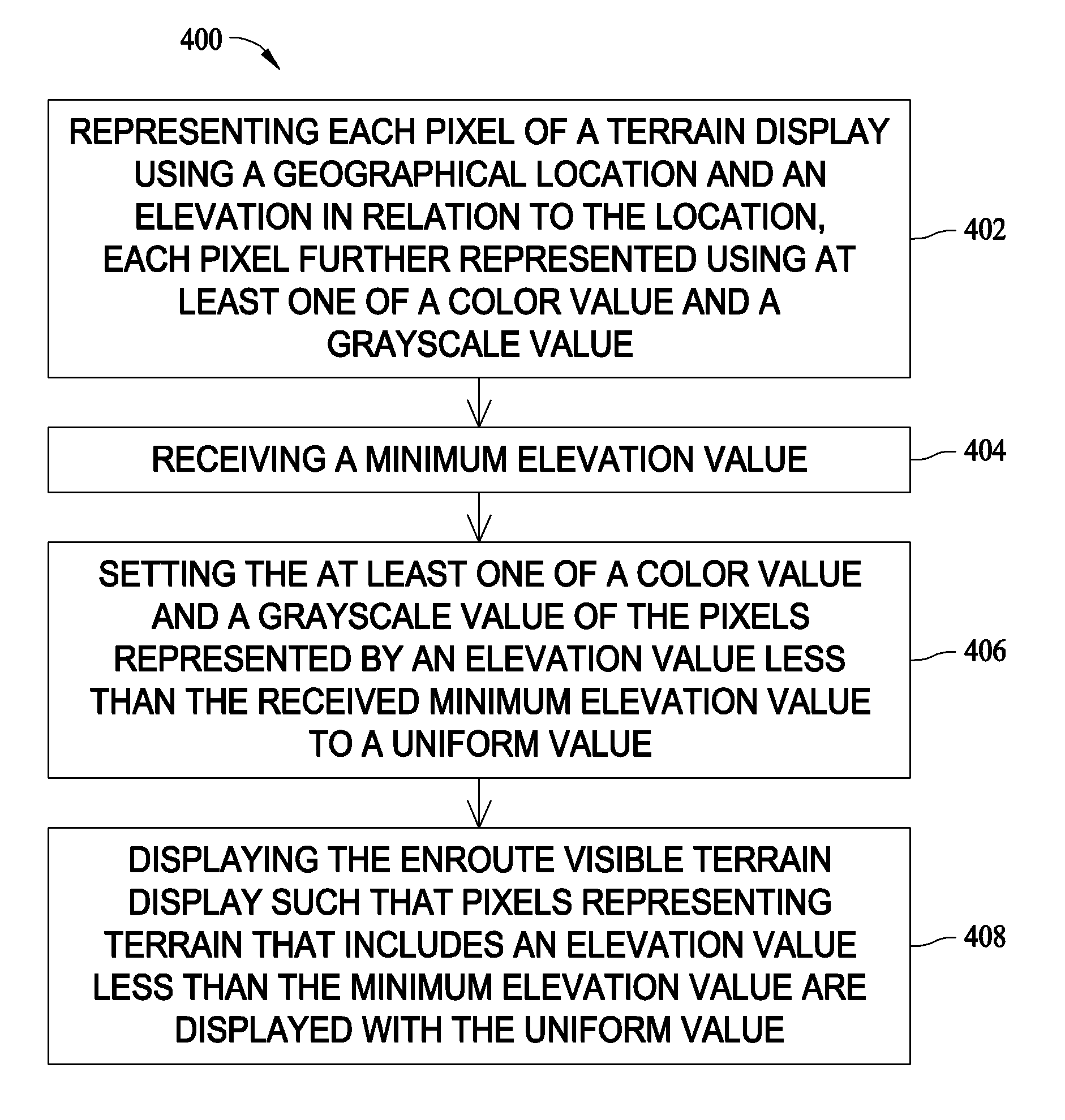
For example, terrain depictions on a cockpit display add information that may not improve situational awareness during particular aspects of a flight or flight planning.
Information that is displayed but not nee

Method used


Image

  • Methods and systems for generating en-route visible terrain displays
  • Methods and systems for generating en-route visible terrain displays
  • Methods and systems for generating en-route visible terrain displays

Examples


Embodiment Construction

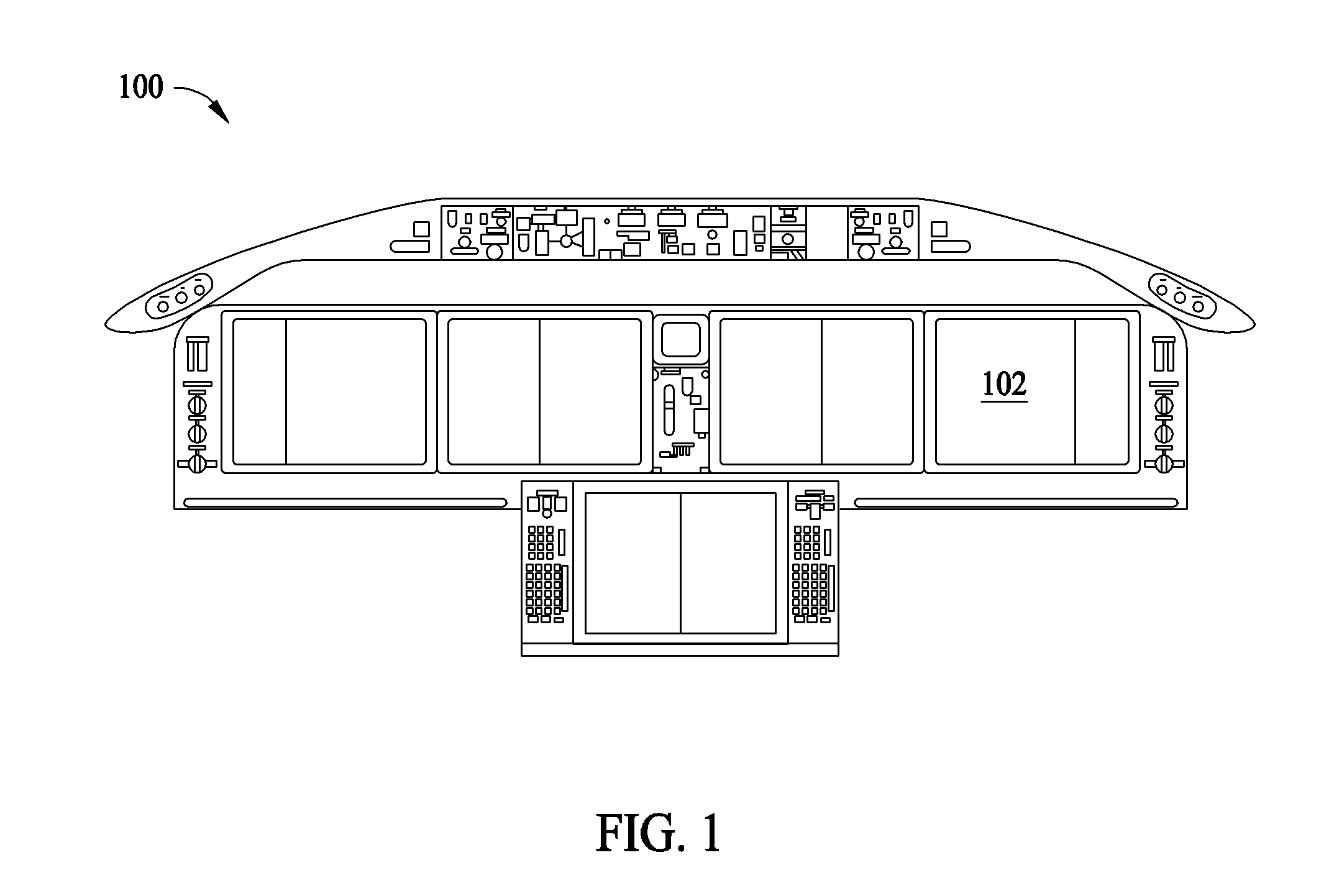
[0011]FIG. 1 is a forward perspective view of an exemplary aircraft cockpit display panel 100 that includes at least one display screen 102 in accordance with an embodiment of the present invention. In the exemplary embodiment, display screen is positioned on aircraft cockpit display panel 100. In an alternative embodiment, display screen 102 is positioned on an auxiliary panel (not shown) located in the cockpit of the aircraft. During aircraft operation, display screen 102 is available for viewing by a pilot and / or co-pilot of the aircraft. Display screen 102 may be used to view data included in an electronic flight bag (not shown), which may be embodied as a standalone device such as, but not limited to a PDA or laptop PC, or as a software component of a system executing on a processor that is part of a subsystem of the aircraft. In the exemplary embodiment, the electronic flight bag includes an electronic storage device configured to store various user-configurable flight-related...


PUM


Abstract

Methods and systems for displaying an en-route visible terrain display for an aircraft are provided. The method includes representing each pixel of a terrain display using a geographical location and an elevation above the location, each pixel further represented using at least one of a color value and a grayscale value, receiving a minimum elevation value, setting the at least one of a color value and a grayscale value of the pixels represented by an elevation value less than the received minimum elevation value to a uniform value, and displaying the en-route visible terrain display such that pixels representing terrain that includes an elevation value less than the minimum elevation value are displayed with the uniform value such that non-terrain-impacted, primary-navigation areas of the display are more easily readable.

Description

CROSS REFERENCE TO RELATED APPLICATIONS[0001]This application claims priority to U.S. Provisional Patent Application Ser. No. 60 / 756,256 filed Dec. 22, 2006, the contents of which are hereby incorporated by reference.BACKGROUND OF THE INVENTION[0002]This invention relates generally to aircraft cockpit displays and more particularly, to methods and systems for displaying terrain maps on aircraft cockpit displays.[0003]At least some known aircraft include cockpit displays use charts that aid in navigation and situational awareness during flight and during flight planning. Charts typically are used for a wide variety of aspects of flight and flight planning and therefore may include data that is not needed for a particular current flight segment or task, but is included for periods when the chart is used for a different task. For example, terrain depictions on a cockpit display add information that may not improve situational awareness during particular aspects of a flight or flight pl...

Claims


Application Information

Patent Timeline
IPC IPC(8): G01C23/00
CPCG09B9/165G01C23/00
Inventor ASPEN, SVEN D.
Owner THE BOEING CO
Why Eureka
Try Eureka