Selection and insertion of static elements in digital maps

a technology of static elements and digital maps, applied in traffic control systems, navigation instruments, instruments, etc., can solve the problems of unclearness, rough texture, and three-dimensional representation of fixtures that may give a more realistic impression of the actual surrounding, so as to enhance the visualization of landmarks and intersections, reduce computational processes, and enhance image quality

Active Publication Date: 2008-09-04
HARMAN BECKER AUTOMOTIVE SYST
View PDF12 Cites 12 Cited by
  • Summary
  • Abstract
  • Description
  • Claims
  • Application Information

AI Technical Summary

Benefits of technology

[0007]A vehicle navigation system guides a driver to a destination by enhancing the visualization of landmarks and intersections. The navigation system stores scalable and compact graphic objects as representations of fixtures or other static elements. The graphic object representations may be used to render perspective views of the fixtures to yield more realistic views. The storage, selection, and generation of the graphic objects may reduce computational processes and enhance image quality.

Problems solved by technology

Due to the limited computer resources, however, three-dimensional representations of fixtures that may give a more realistic impression of the actual surrounding, such as the actual vegetation, may be relatively rough-textured and unclear.

Method used


Image

  • Selection and insertion of static elements in digital maps
  • Selection and insertion of static elements in digital maps
  • Selection and insertion of static elements in digital maps

Examples


Embodiment Construction

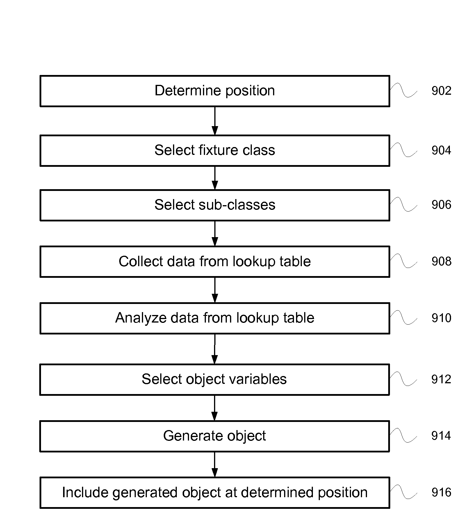
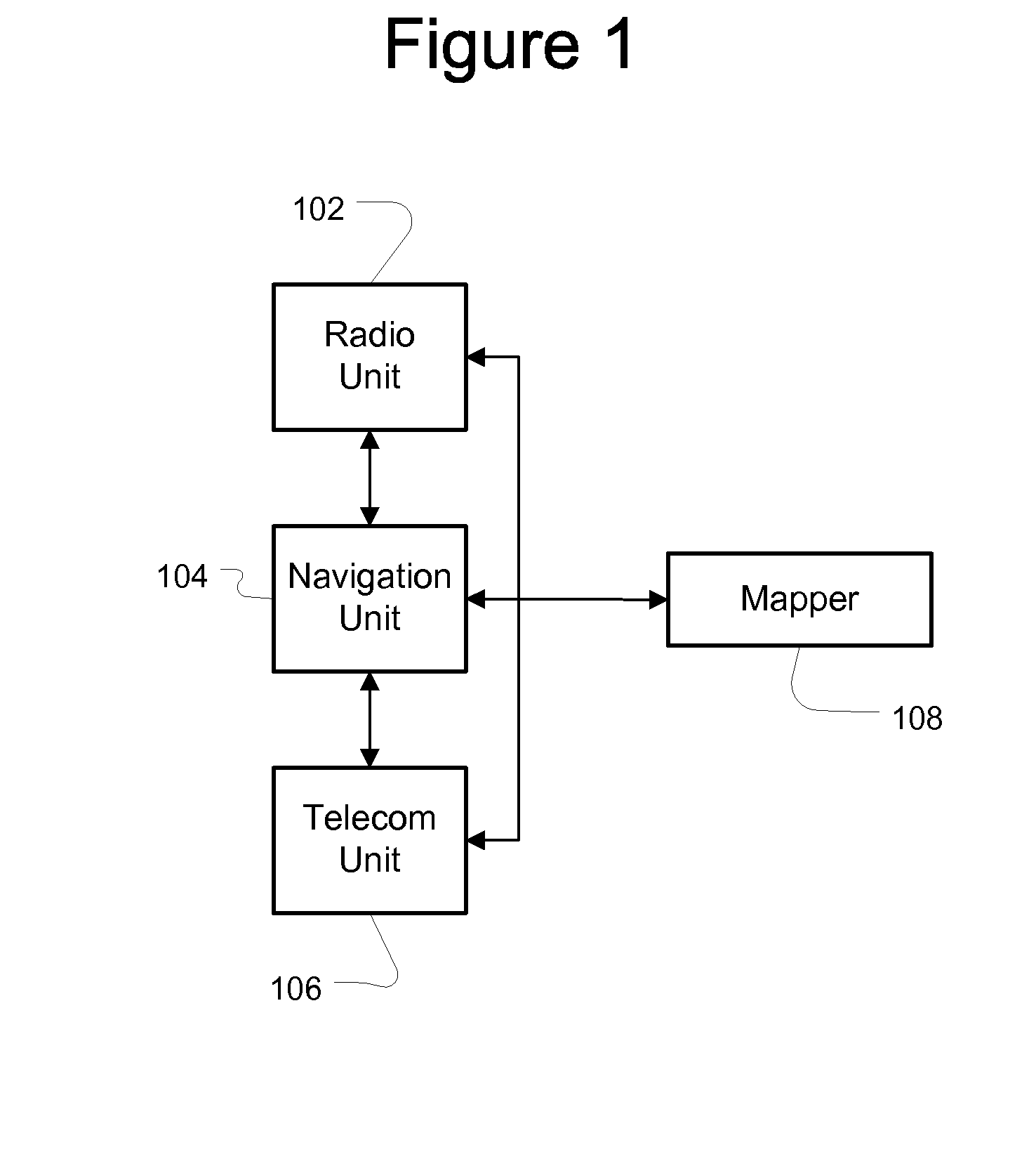
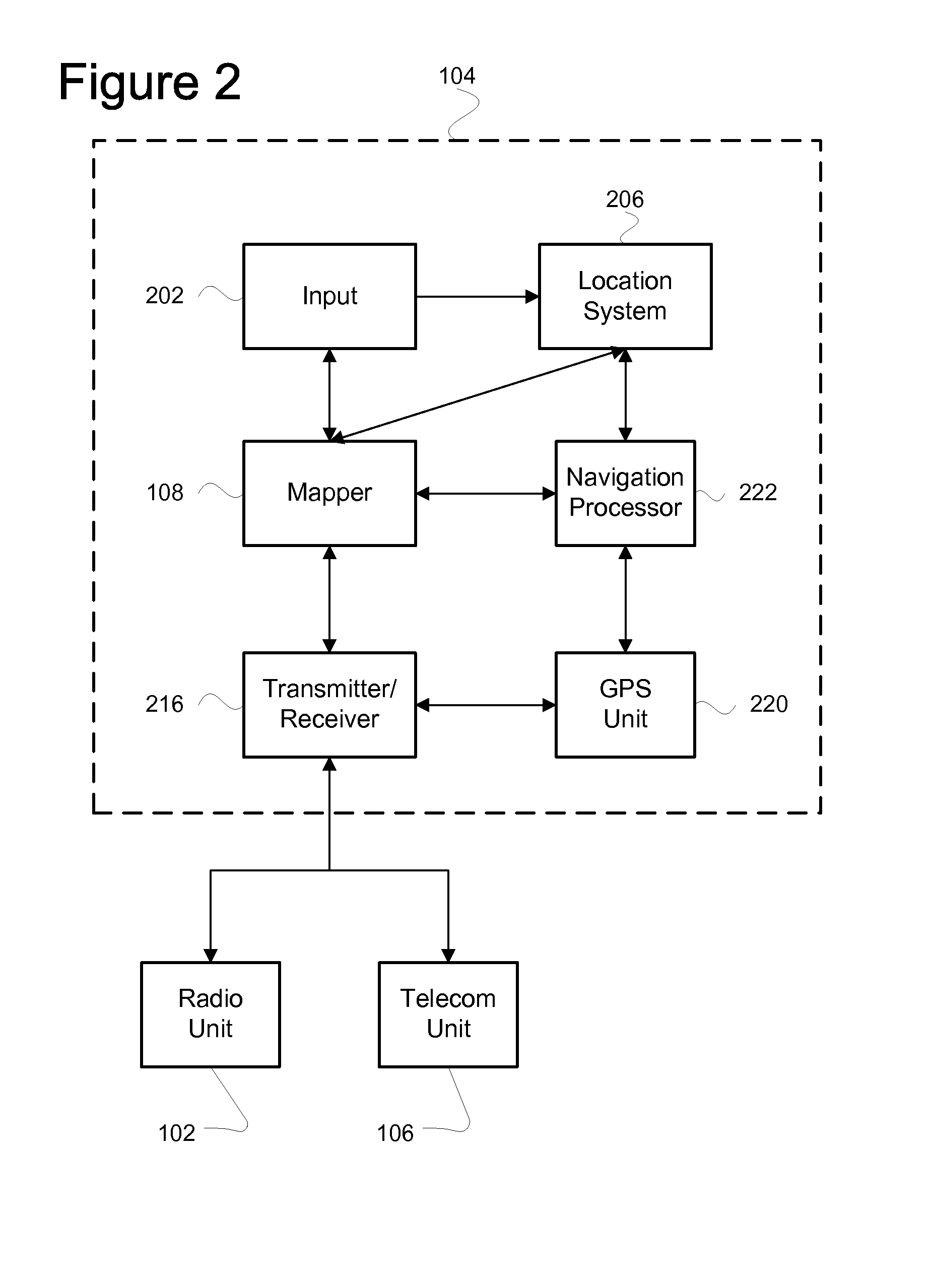
[0021]FIG. 1 is a block diagram of a vehicle interface. The vehicle may include an automobile, such as a car, truck, or motorcycle, or may include any device for transporting people or things. The interface may comprise a navigation system 104 in communication with a radio unit 102, a telecom unit 106 and a mapper 108. The interface allows a user to provide information or receive information from the radio unit 102, navigation unit 104, and / or telecom unit 106. The mapper 108 may provide maps and features that are displayed by the navigation unit 104.

[0022]The navigation unit 104 may provide maps with directions and preferred route information to a destination that guide a driver by enhancing the visualization of upcoming landmarks and intersections. The Global Positioning System (GPS) may be used to locate a user's position that is displayed on the map. The navigation unit 104 may store scalable and compact vector graphics representations of landmarks and intersections that may be ...


PUM


Abstract

A navigation system may display route information that includes a display of the fixtures that are located on or near the route. The fixtures may be selected and inserted into the digital map as graphical objects. The graphical objects may be classified into a class and at least one sub-class. The classification data may be used to select and generate the graphical objects.

Description

[0001]This application claims the benefit of priority from European Patent Application No. 06021155.4, filed on Oct. 9, 2006, which is incorporated by reference.BACKGROUND OF THE INVENTION[0002]2. Technical Field[0003]This application relates to managing and displaying static elements or fixtures in two-dimensional and three-dimensional digital maps.[0004]3. Related Art[0005]Vehicle navigation systems analyze location and motion data provided by the Global Positioning System (GPS), motion sensors such as automatic braking system (ABS) wheel sensors, and digital maps to determine the position and velocity of a vehicle. Navigation systems generate digital maps to represent cartographic features, such as streets, intersections, signs, street lights, buildings, landmarks, parks and rivers. The digital maps may also display points-of-interest such as gas stations, restaurants, landmarks, or other points-of-interest. The navigation system provides an indicator of the vehicle's actual posi...

Claims


Application Information

Patent Timeline
Patent Type & Authority Applications(United States)
IPC IPC(8): G01C21/00G06F17/30G06F7/06G06T17/05
CPCG01C21/32Y10S345/958G09B29/10G01C21/36G01C21/3878G06T17/05G08G1/0968G01C21/3667G01C21/387
Inventor STRASSENBURG-KLECIAK, MAREKMEYER, HENDRIK
Owner HARMAN BECKER AUTOMOTIVE SYST
Why Eureka
Try Eureka