Data Partitioning Systems

Inactive Publication Date: 2008-09-18
1 SPATIAL GRP
View PDF4 Cites 49 Cited by
  • Summary
  • Abstract
  • Description
  • Claims
  • Application Information

AI Technical Summary

Benefits of technology

[0012]The determining of partitions is facilitated by populating a data structure, as the partitions are determined, with, for each grid cell, cell co-ordinates, account for the number of objects in the cell (optionally broken down by type) and a partition identifier for the cell. This facilitates allocation of a partition identifier to each spatial feature object. Thus preferably a data structure is also created in which each spatial feature object is associated with or allocated to a partition. A separate procedure or script may be employed to populate this data structure or tab

Problems solved by technology

For example, for Oracle partitioning may not be d

Method used


Image

  • Data Partitioning Systems
  • Data Partitioning Systems
  • Data Partitioning Systems

Examples


Embodiment Construction

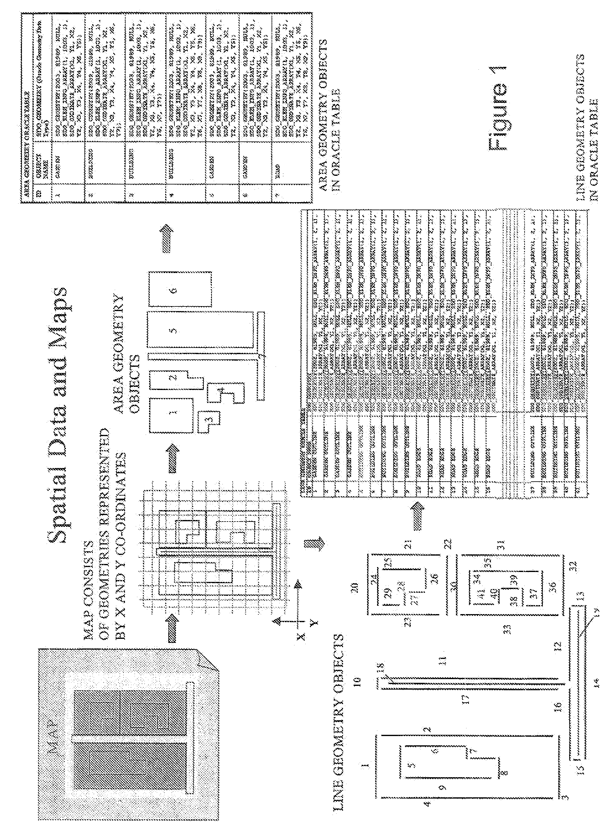
[0027]We first describe, by way of background, how map geometries are stored in Oracle™. As illustrated in FIG. 1, the geometries displayed on the map are stored in one or more Oracle™ tables. Each feature on a map can be made up of several area / polygon objects of multiple line objects. Each geometry object has associated X and Y co-ordinates for each vertex of the geometry, so we know where the feature exists in the real world and therefore where the feature will be displayed on a map.

[0028]In FIG. 1, a building on the map can be stored in Oracle as one area / polygon object and / or as several line objects, where each line represents an outer-wall of the building. The area / polygon representation of the building is stored in a separate Oracle table to the line objects.

[0029]We next describe databases and partitioning. The database tables that hold all of the area and line geometries can get very large. For example, there are over 262 million line geometries for the England and Wales Or...


PUM


Abstract

This invention generally relates to methods, systems, data structures and computer program code for managing spatial data, in particular very large volumes of data such as map data for a region or country. Thus we describe a method of partitioning a database of spatial data, the database including a plurality of spatial feature objections, the method comprising: reading data from said database grid cell-by-grid cell, a said grid cell comprising a cell of a grid spatially subdividing a region of spatial coverage of said database, each said grid cell including spatial feature objects; and determining a set of spatial partitions for said database, each grid cell being allocated to a said partition, responsive to a number of said spatial feature objects in each said grid cell.

Description

FIELD OF THE INVENTION[0001]This invention generally relates to methods, systems, data structures and computer program code for managing spatial data, in particular very large volumes of data such as map data for a region or country.BACKGROUND OF THE INVENTION[0002]Until recently map data comprises little more than image files but recently more powerful techniques for representing maps have emerged based upon a database model in which spatial or geometry data is one aspect of an object which, generally, includes a range of other types of data in particular, for systems developed by the applicant, topological data. This facilitates, for example, rule-based spatial data processing which can be used for a number of purposes including data cleaning, the implementation of mechanisms to ensure data consistency / continuity between different regions or hierarchies of a map, and for searching. A typical implementation employs such as Oracle 9i or 10g which is configured for processing spatial...

Claims


Application Information

Patent Timeline
IPC IPC(8): G06F17/00
CPCG06F17/30241G06F16/29
Inventor MOFFAT, DAWN
Owner 1 SPATIAL GRP
Why Eureka
Try Eureka