Corridor mapping with alternative routes

a technology of corridor mapping and alternative routes, applied in the direction of maps/plans/charts, navigation instruments, maps, etc., can solve the problems of limiting the amount of map data that can be transmitted over the air from a server to a user's client device, subject to bandwidth constraints,

Inactive Publication Date: 2009-05-14
INTEL CORP
View PDF55 Cites 57 Cited by
  • Summary
  • Abstract
  • Description
  • Claims
  • Application Information

AI Technical Summary

Benefits of technology

[0017]The server calculates and downloads optimal routes to the client device, together with map data for other roads and features near the optimal and alternative routes. This is done prior to downloading map data to the client. The algorithm used to calculate the optimal routes is efficient, and allows calculations for the optimal route from a first deviation to be reused when calculating the optimal route from a second deviation. As a consequence, optimal routes from many deviations may be calculated in a reasonable amount of time.

Problems solved by technology

Off-board navigation systems, however, are subject to bandwidth constraints, which limit the amount of map data that can be transmitted over the air from a server to a user's client device.
Therefore, the amount of ancillary road data that can be downloaded along with the actual route is limited.
There is a possibility that the user may deviate from the original route to a new position, such that the best alternative route from the new position to the destination takes the user a long way from the original route.
Furthermore, the user may deviate from the alternative route, requiring a new alternative route, and so on.
Conventional systems would either require additional communication between the server and the user's client device, or the use of a non-optimal alternative route.
Calculating an optimal route from every possible deviation is generally not feasible, since the time and resources required to compute all possible alternative routes would not be reasonable.
An error-prone junction is a location where two or more roads intersect in which there is a high probability that the user will make a mistake in attempting to follow the prescribed instructions.

Method used


Image

  • Corridor mapping with alternative routes
  • Corridor mapping with alternative routes
  • Corridor mapping with alternative routes

Examples


example

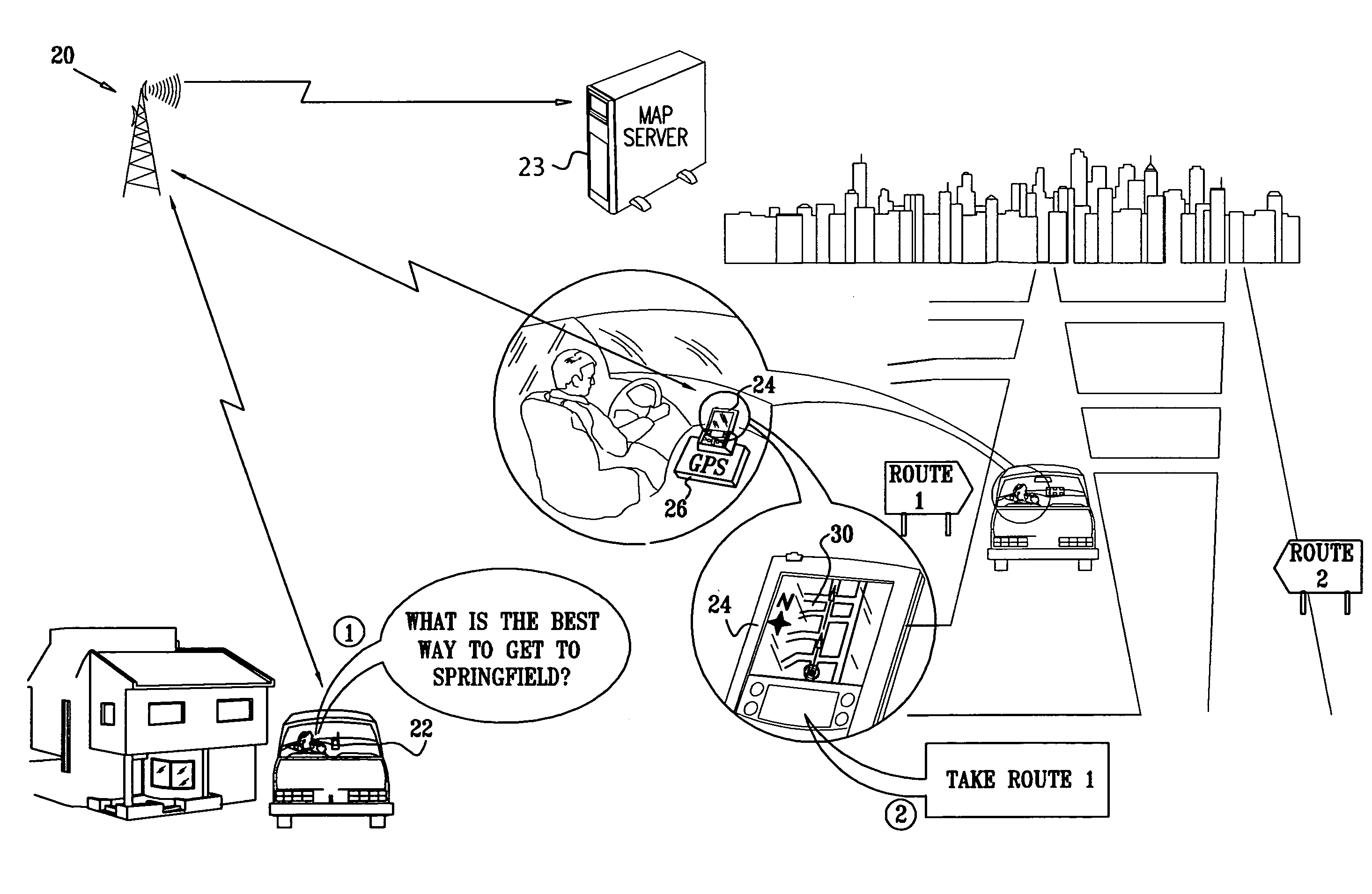
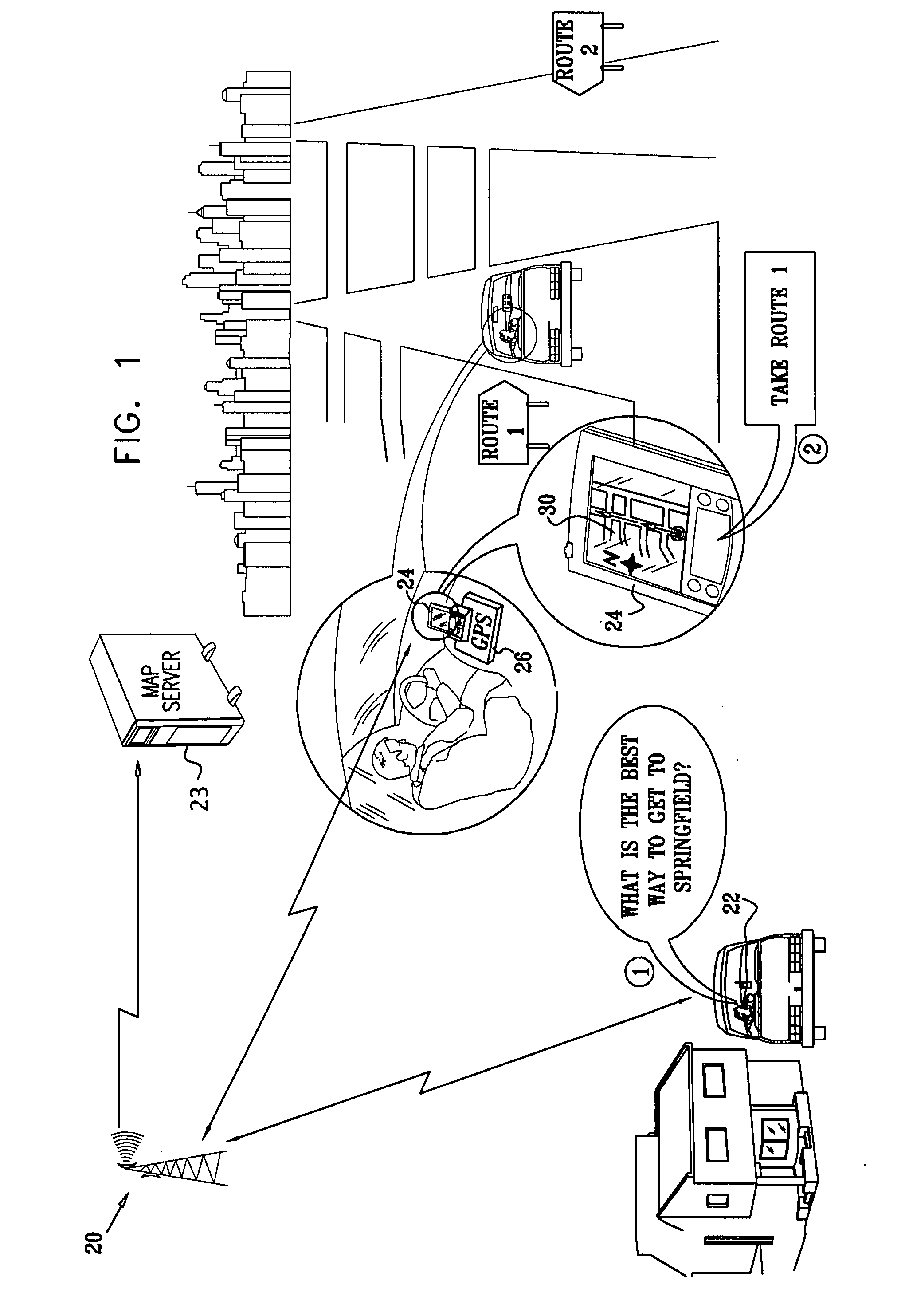
[0089]Reference is now made to FIG. 6, FIG. 7, and FIG. 8, which are maps that illustrate the above-described method of calculating alternative routes to optimal route 101, in accordance with an embodiment of the present invention.

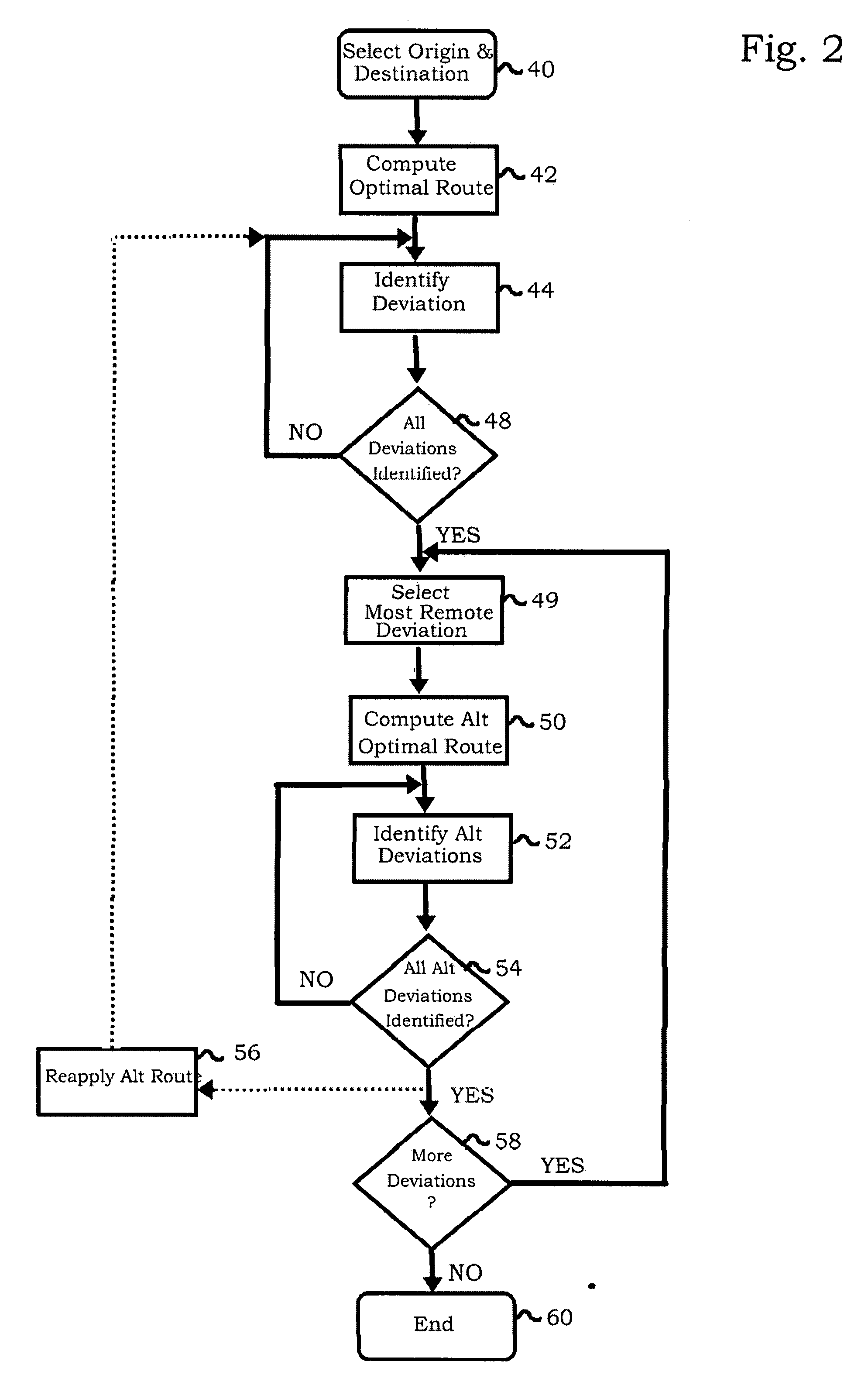
[0090]FIG. 6 shows a map with a route 232 from origin 102 to destination 104 and illustrates a first phase of the A* algorithm. The A* algorithm operates generally from destination 104 toward junction 108, as indicated by an arrow 234, within an approximately elliptical region 236. Junction 108 is found on the deviation on route 232 that is most remote from destination 104. The algorithm processes optimal routes for deviations within region 236, as described above with respect to FIG. 2, builds a priority queue and remembers data for nodes calculated. Nodes outside region 236, for example a node represented by junction 238, are not processed at this stage. The deviation containing junction 108, being the most remote deviation, was chosen first by the A* al...

embodiment 1

ALTERNATIVE EMBODIMENT 1

[0099]An optimal route is computed from each identified deviation to the destination. This will result a relatively heavy computational load, particularly on routes having many deviations.

embodiment 2

ALTERNATIVE EMBODIMENT 2

[0100]In this embodiment, alternative routes are calculated, e.g., using the A* algorithm, in a forward direction from identified deviations that are chosen in a sort order according to proximity of the deviations to the destination. The real weights and lengths computed for each node are memorized. A disadvantage of this approach is that recalculation of alternative routes from previously unevaluated deviations does not reuse these weights. The advantage of reusability of the earlier calculation is largely lost.


PUM


Abstract

A navigation system computes an optimal route between an origin and a destination using a map server. The map server identifies likely points of deviation from the optimal route, and prior to transmitting map data to a client device, establishes alternative optimal routes from the deviations to the destination. A search algorithm is employed in which computation effort is reduced through improved heuristics and enhanced recognition of previously expanded nodes and alternative routes through nodes determined in prior iterations of the search. A route corridor map including the optimal route and alternative routes is download from the map server to the client device.

Description

BACKGROUND OF THE INVENTION[0001]1. Field of the Invention[0002]This invention relates generally to methods and systems for electronic download and display of route maps. More particularly, this invention relates to management of deviations from a calculated route map.[0003]2. Description of the Related Art[0004]A variety of systems are known in the art for providing drivers with in-vehicle electronic routing maps and navigation aids. These systems are commonly coupled to a location-finding device in the vehicle, such as a Global Positioning System (GPS) receiver. The GPS receiver automatically determines the current location of the vehicle, to be displayed on the map and used in determining routing instructions.[0005]In-vehicle navigation systems fall into two general categories: “on-board” systems, in which the map data are stored electronically in the vehicle (typically on optical or magnetic media); and “off-board” systems, in which the map data are furnished by a remote map ser...

Claims


Application Information

Patent Timeline
Patent Type & Authority Applications(United States)
IPC IPC(8): G01C21/34
CPCG01C21/32G09B29/106G01C21/3415G01C21/3889G01C21/3811
Inventor PERI, OMER SHMUELSAGI, NOAMZVI, TALI
Owner INTEL CORP
Why Eureka
Try Eureka