Geographical data collecting device

Active Publication Date: 2009-09-10
KK TOPCON
View PDF44 Cites 35 Cited by
  • Summary
  • Abstract
  • Description
  • Claims
  • Application Information

AI Technical Summary

Benefits of technology

[0018]Further, the present invention provides the geographical data collecting device as described above, wherein the control arithmetic unit sets, as reference, the horizontal angle and the azimuth angle measured by the tilt sensor and the azimuth sensor at the time when the reference image is taken and compensates a vertical angle and a horizontal angle according to the measuring points calculated based on the result of matching. As a result, even when considerable errors may occur in the azimuth sensor, it is possible to improve the relative measurement accuracy between the measuring points.
[0019]Also, the present invention provides the geographical data collecting device as described above, wherein the control arithmetic unit displays a plurality of measuring points to match a plurality of measurements on the reference image and calculates a horizontal distance between two measuring points on the reference image as designated via the touch panel. Accordingly, the distance between two points can be calculated accurately by simple procedure.
[0020]Further, the present invention provides the geographical data collecting device as described above, wherein the control arithmetic unit displays a plurality of measuring points to match a plurality of measurements on the reference image and calculates a horizontal area enclosed by at least three measuring points on the reference image as designated via the touch panel. As a result, the measurement of each area can be calculated by simple operation and with accuracy.
[0021]Also, the present invention provides the geographical data collecting device as described above, further comprising a GPS device, wherein the control arithmetic unit determines the measuring points through the matching of the reference image and the measured image based on geographical data obtained by the GPS device and based on the vertical angle, the horizontal angle and the azimuth angle which are initial values of the matching and are measured by the tilt sensor and the azimuth sensor when the reference image is taken, the control arithmetic unit corrects the vertical

Problems solved by technology

As a result, considerable time is required for recording each measuring operation.
This leads to the increa

Method used


Image

  • Geographical data collecting device
  • Geographical data collecting device
  • Geographical data collecting device

Examples


Embodiment Construction

[0029]A description will be given below on the best mode for carrying out the present invention by referring to the attached drawings.

[0030]First, referring to FIG. 1, a description will be given on a geographical data collecting device, to which the present invention is carried out.

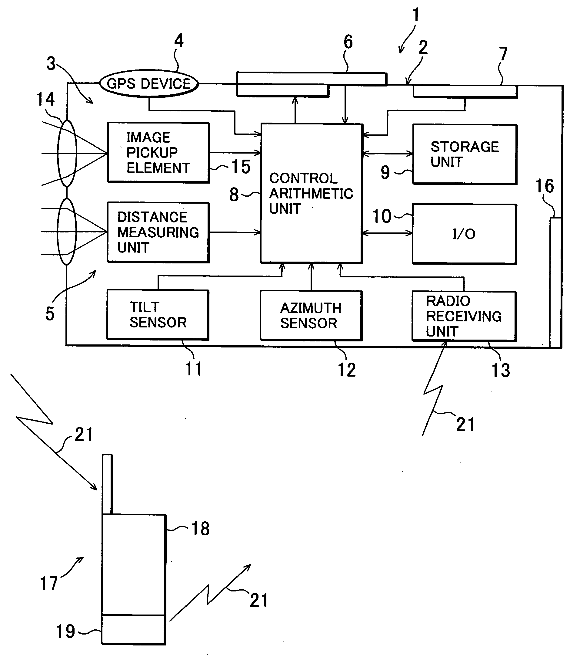
[0031]In FIG. 1, reference numeral 1 denotes a geographical data collecting device, and numeral 2 represents a portable type housing. In the housing 2, there are provided an image pickup unit 3, a GPS device 4, a distance measuring unit 5, a display unit 6 and an operation unit 7. Inside the housing 2, there are provided a control arithmetic unit 8, a storage unit 9, an input / output control unit 10, a tilt sensor 11, an azimuth sensor 12, and a radio receiving unit 13. The image pickup unit 3 is a digital camera, for instance. The image pickup unit 3 comprises an objective lens 14 and an image pickup element 15, which is an aggregate of a multiple of pixels such as CCD, CMOS sensor, etc. The image pickup...


PUM


Abstract

The present invention provides a geographical data collecting device, which comprises a distance measuring unit 5 for projecting a distance measuring light and for measuring a distance to an object to be measured, an image pickup unit 3 for taking an image in a measuring direction, a display unit 6 for displaying an image picked up, a touch panel installed to match a position of screen of the display unit, a tilt sensor 11 for detecting a tilting, an azimuth sensor 12 for detecting a horizontal angle in the measuring direction, and a control arithmetic unit 8, wherein the image pickup unit takes an image of a measurement range, acquires a reference image, is directed to a selected measuring point in the reference image, and acquires a measured image with the measuring point as a center, and wherein said control arithmetic unit calculates the measuring point in the reference image through an image matching of the reference image and the measured image and displays a measuring point on at least one of the reference image or the measured image.

Description

BACKGROUND OF THE INVENTION[0001]The present invention relates to a portable type geographical data collecting device using GPS. In particular, the invention relates to a geographical data collecting device, by which it is possible to acquire an image data of a place to be measured, to plot a point to be measured in the image, to perform a measurement or the like while visually confirming the point to be measured, and to collect a result of the measurement together with the image data.[0002]In recent years, a global positioning system (GPS) has been widely propagated, and a present position can be acquired by a GPS device in easy manner and with high accuracy, and the present position can be displayed in a map information.[0003]A simple and convenient geographical data collecting device is desired, by which it is possible to measure easily a position of an object to be measured, to acquire an image data of a measuring point or of the object to be measured, and to move easily, when i...

Claims


Application Information

Patent Timeline
IPC IPC(8): H04N7/18
CPCG01C11/12
Inventor OTANI, HITOSHINAKAMURA, MITSUTAKA
Owner KK TOPCON
Why Eureka
Try Eureka