Map enhanced positioning sensor system

a positioning sensor and enhanced technology, applied in the field of vehicle positioning systems, can solve the problems of time delays and other errors, and affect the accuracy of map-matched positions, and achieve the effect of minimizing positioning errors and maximizing accuracy

Inactive Publication Date: 2010-05-13
VISTEON GLOBAL TECH INC
View PDF18 Cites 50 Cited by
  • Summary
  • Abstract
  • Description
  • Claims
  • Application Information

AI Technical Summary

Benefits of technology

[0007]Concordant and consistent with the present invention, an enhanced vehicle positioning system and method for determining a vehicle position and travelling path, wherein the system and method leverage road attributes, vehicle dynamics, and vehicle position data to minimize positioning errors and maximize accuracy has surprisingly been discovered.

Problems solved by technology

Time delays and other errors can be introduced from many sources including atmospheric conditions, environmental conditions, vehicle yaw, speed and steering angle sensors, and computational latency.
Therefore, the accuracy of the map-matched position is affected by four main factors and associated errors: 1) matching the position to the correct road segment; 2) the accuracy of the GPS / DR position; 3) the distance between the equipped vehicle and the center of the road; and 4) errors contained within the map database itself.

Method used


Image

  • Map enhanced positioning sensor system
  • Map enhanced positioning sensor system
  • Map enhanced positioning sensor system

Examples


Embodiment Construction

[0015]The following detailed description and appended drawings describe and illustrate various embodiments of the invention. The description and drawings serve to enable one skilled in the at to make and use the invention, and are not intended to limit the scope of the invention in any manner. In respect of the methods disclosed, the steps presented are exemplary in nature, and thus, the order of the steps is not necessary or critical.

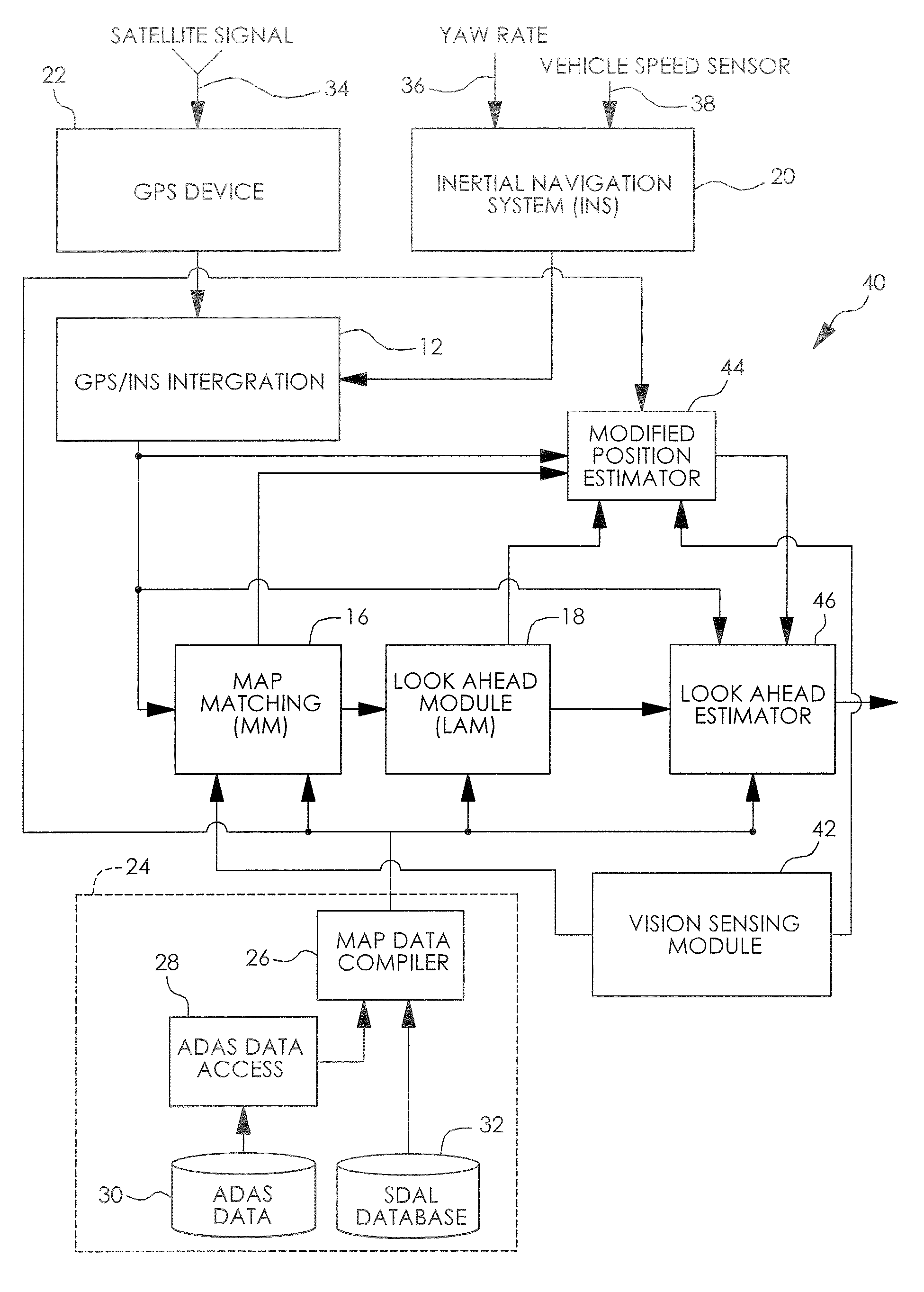
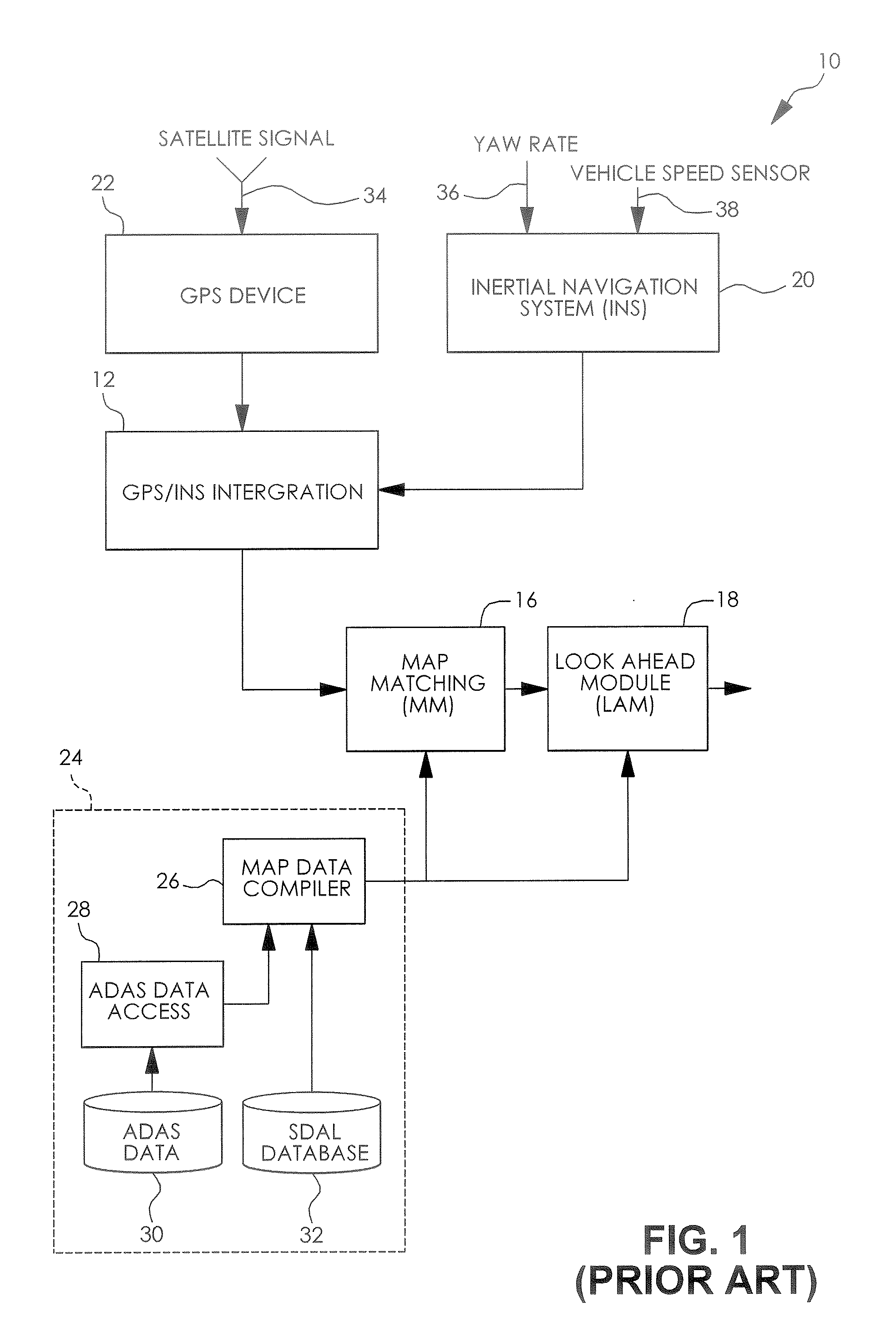
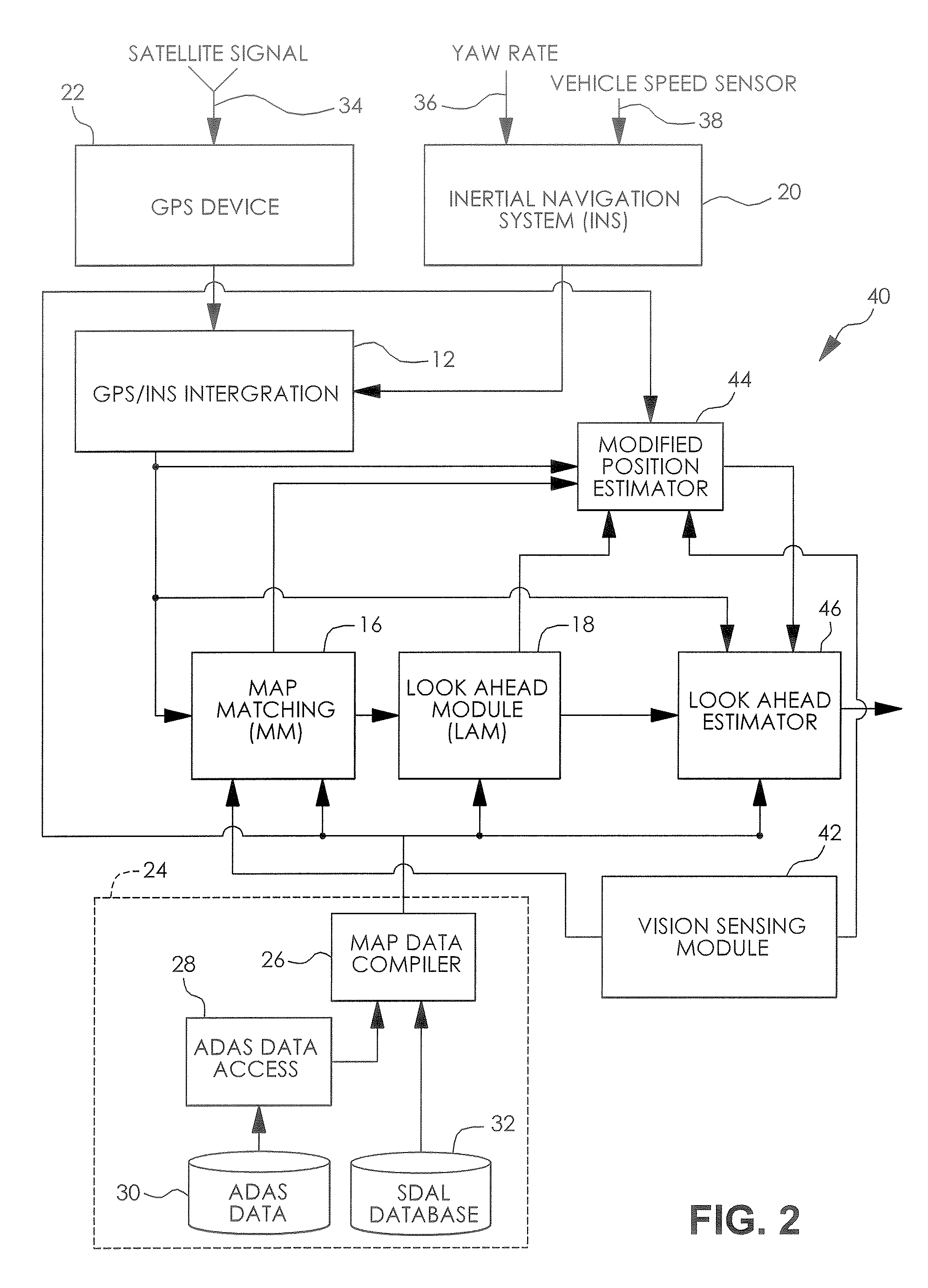
[0016]Referring to FIG. 1, there is illustrated a vehicle positioning system 10 for providing a vehicle position and predicted path of travel, according to the prior art. As shown, the vehicle positioning system 10 includes a global positioning system (GPS), a GPS / INS integration module 12, a map-matching module 16, and a look-ahead module 18. The system 10 is also provided with an inertial navigation system 20, a GPS receiver 22, a map database 24, a yaw rate sensor 36, and a vehicle speed sensor 38. The map database 24 includes a map data compiler 26...


PUM


Abstract

An enhanced positioning system includes a vehicle positioning system adapted to transmit an output representing at least one of a current position, a future position, and a path of a vehicle and at least one module in communication with the vehicle positioning system, wherein the at least one module obtains data and information related to at least one of a road attribute, a vehicle dynamics, and a vehicle position, analyzes the data and information, and modifies the output of the vehicle positioning system in response to the analysis of the data and information.

Description

FIELD OF THE INVENTION[0001]The invention relates to vehicle positioning systems. More particularly, the invention is directed to a map enhanced positioning sensor system and a method for determining an accurate instantaneous position of a vehicle and an accurate prediction of the future position of a vehicle.BACKGROUND OF THE INVENTION[0002]Many advanced driver awareness systems (ADAS), also known as driver assistance systems or active safety systems, would benefit from more accurate and timely information about both a current and a future vehicle position in real-time.[0003]Currently, most applications that require real-time position information use a position derived from a Global Positioning System (GPS) supplemented with dead reckoning (DR). In addition the DR provides positioning inputs when GPS satellite signals are not available. Time delays and other errors can be introduced from many sources including atmospheric conditions, environmental conditions, vehicle yaw, speed and...

Claims


Application Information

Patent Timeline
Patent Type & Authority Applications(United States)
IPC IPC(8): G01C21/34
CPCG01C21/30G01C21/165
Inventor TIERNAN, TIMOTHY ARTHURIBRAHIM, FAROOG ABDEL-KAREEMFREEMAN, KENNETH AARON
Owner VISTEON GLOBAL TECH INC
Why Eureka
Try Eureka