Determining Travel Path Features Based on Retroreflectivity

a technology of retroreflectivity and features, applied in the field of collecting and analyzing data, can solve the problems of time-consuming and/or complex, and the collection and processing procedures of geographic data for navigation systems may be a significant undertaking, and the collection of roads in a geographic area and the development of useful geographic data for navigation devices may be time-consuming and/or complex

Active Publication Date: 2010-08-26
HERE GLOBAL BV
View PDF26 Cites 64 Cited by
  • Summary
  • Abstract
  • Description
  • Claims
  • Application Information

AI Technical Summary

Problems solved by technology

However, collection and processing procedures to provide geographic data for use in navigation systems may be a significant undertaking.
For example, collection of data about the roads in a geographic area and developing useful geographic data for navigation devices may be time consuming and / or intricate.

Method used


Image

  • Determining Travel Path Features Based on Retroreflectivity
  • Determining Travel Path Features Based on Retroreflectivity
  • Determining Travel Path Features Based on Retroreflectivity

Examples


Embodiment Construction

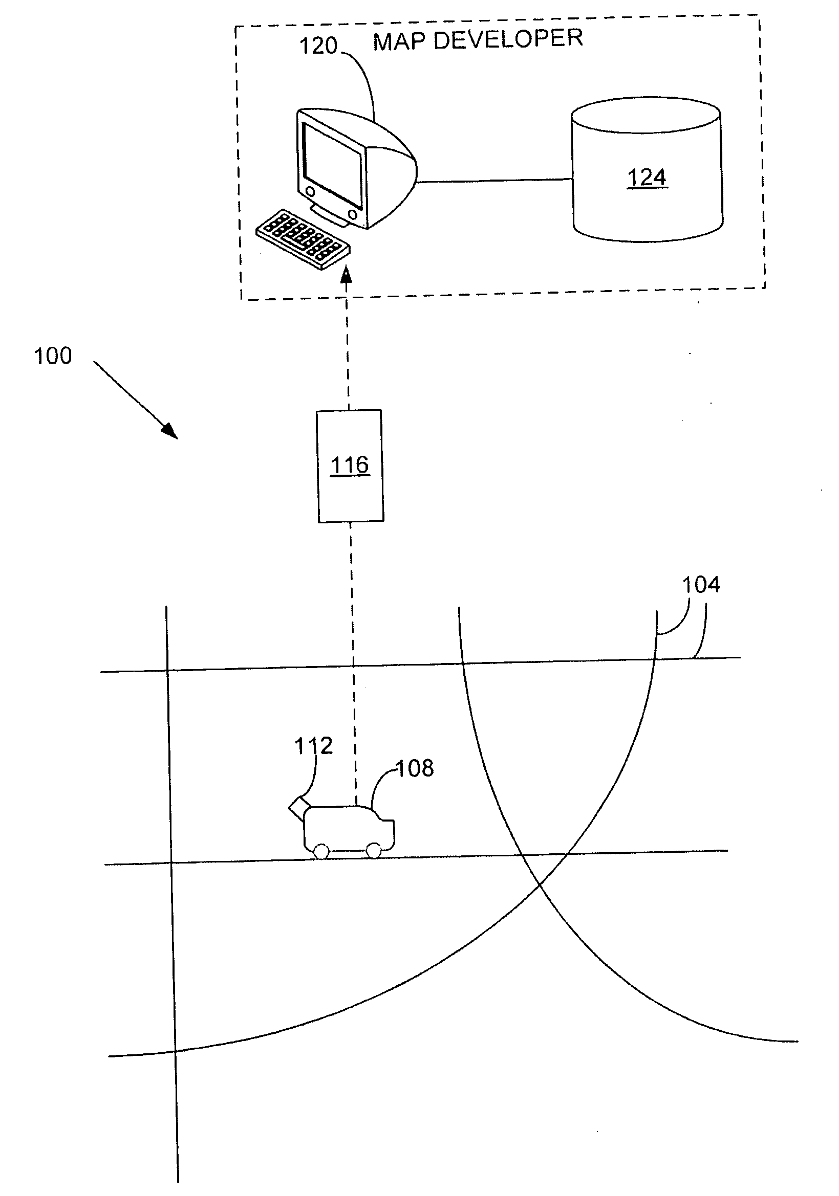
[0019]FIG. 1 shows one embodiment of a system 100 for determining geographic features corresponding to a travel path to develop a map database. The system 100 includes, but is not limited to, an object 108 travelling on a path network 104, a processing device 120, and a geographic, map, navigation, and / or navigation-related database 124. Additional, fewer, or different components may be provided.

[0020]The object 108 is a vehicle, such as a car, truck, motorcycle, bicycle, Segway, or other transportation device or mechanical device used to move on the path network 104. Alternatively, the object 108 may represent a pedestrian, such as a human being or animal, that walks or moves along the path network 104. The path network 104 is a road network and / or a collection of other pathways. For example, the path network 104 is a road network made up of various roads. The roads may be used to drive vehicles on, such as local and neighborhood streets and highways. Also, instead of or in additio...


PUM


Abstract

Systems, devices, features, and methods for determining geographic features corresponding to a travel path to develop a map database, such as a navigation database, are disclosed. For example, one method comprises emitting light from a light source, such as a LIDAR device, while on the travel path. Returning light is received based on the emitted light. The returning light is used to generate data points representing an area about the travel path. The data points are filtered as a function of a return intensity value to identify a feature associated with the travel path, in which the feature is treated with a retroreflective substance.

Description

BACKGROUND OF THE INVENTION[0001]The present invention relates to collecting and analyzing data and, more particularly, to determining geographic features corresponding to a travel path from collected data.[0002]Generating and presenting real-world data models assist end users in a variety of experiences. For example, navigation systems or devices provide useful displays and visual guidance in instructing or guiding people to desired destinations. Navigation devices use map or geographic data, including navigation-related attributes, to provide features, such as map display and map guidance. Some or all of the geographic data may be provided and / or generated from collected information.[0003]However, collection and processing procedures to provide geographic data for use in navigation systems may be a significant undertaking. For example, collection of data about the roads in a geographic area and developing useful geographic data for navigation devices may be time consuming and / or i...

Claims


Application Information

Patent Timeline
Patent Type & Authority Applications(United States)
IPC IPC(8): G06F19/00G01S1/00G01C3/06G01S17/89
CPCG01S17/89G01C3/06G09B29/008
Inventor STROILA, MATEI NICOLAICHEN, XINMOGHADDAM, MAHSA KAMALILU, VICTORKOHLMEYER, BRADLEY DEAN
Owner HERE GLOBAL BV
Why Eureka
Try Eureka