Route search method and apparatus for navigation system utilizing map data of XML format

a map data and navigation system technology, applied in surveying and navigation, navigation instruments, instruments, etc., can solve the problems of time-consuming and inefficient process of storing and retrieving such a large amount of map data during the route guidance operation, data format is not logically related, and complex and time-consuming generating and modifying map data, etc., to improve the efficiency and accuracy of calculating, efficient search the route, and the effect of efficient search

Active Publication Date: 2010-10-14
ALPINE ELECTRONICS INC
View PDF11 Cites 106 Cited by
  • Summary
  • Abstract
  • Description
  • Claims
  • Application Information

AI Technical Summary

Benefits of technology

[0020]Another aspect of the present invention is an apparatus for efficiently searching the route for implementing the steps defined in the methods of the present invention noted above. The apparatus includes various means to evaluate virtual links connecting the boundary nodes of administrative regions based on the costs and to select candidate total routes and selects an optimum route to the destination. The apparatus is able to dramatically improve the efficiency and accuracy of calculating an optimum route to the destination for the navigation system using the XML format map data constructed in a layered structure based on administrative areas or jurisdictions.
[0021]According to the present invention

Problems solved by technology

Thus, the process of storing and retrieving such a large amount of map data during the route guidance operation can be time consuming and inefficient.
The data format based on the meshed layers described above has disadvantage in that gen

Method used


Image

  • Route search method and apparatus for navigation system utilizing map data of XML format
  • Route search method and apparatus for navigation system utilizing map data of XML format
  • Route search method and apparatus for navigation system utilizing map data of XML format

Examples


Embodiment Construction

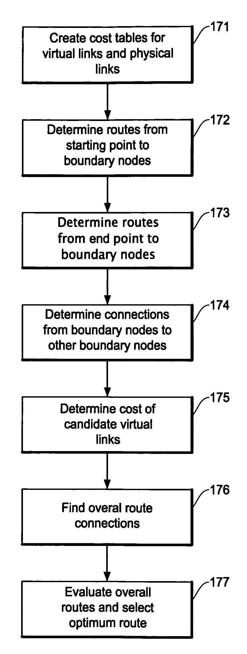
[0041]The route search method of the present invention for a navigation system will be described in more detail with reference to the accompanying drawings. The route search method of the present invention utilizes map data in an extensible markup language (XML) format and a scalable vector graphics (SVG) format converted from general purpose geographic data such as GDF (geographic data file). The map data in the XML / SVG (hereafter “XML” or “XML map data”) format for the navigation system is further constructed in a layered structure, i.e., it has a plurality of different data levels, based on administrative areas or jurisdictions. The administrative ares or jurisdictions are cities, counties, states, and countries. Within the context of the present invention, such an administrative area will also be referred to as “administrative region”, “administrative cluster”, or “cluster”.

[0042]Typically, the map data involved in an administrative cluster include cost tables of candidate virtu...


PUM


Abstract

A route search method for a navigation system using the XML map data that is layered based on administrative regions improves efficiency and accuracy of finding an optimum route. The method includes the steps of establishing boundary nodes on boundaries of administrative regions, creating cost information on virtual links that connect the boundary nodes on the administrative regions and physical links on a base layer, selecting candidate virtual links regions by evaluating the cost information, detecting candidate total routes between the start point and destination by connecting the candidate virtual links and other routes, and applying physical links in the base layer to the candidate total routes for further evaluating the costs of the total routes to select the most cost effective total route.

Description

FIELD OF THE INVENTION[0001]This invention relates to a route search method and apparatus utilizing XML format map data, and more particularly, to a route search method and apparatus for a navigation system utilizing XML format map data that is configured by layered clusters of administrative region by connecting boundary nodes of the administration regions.BACKGROUND OF THE INVENTION[0002]A navigation system performs travel guidance for enabling a user to easily and quickly reach the selected destination. A typical example is a vehicle navigation system which guides a driver of a vehicle to a destination through a calculated route. Such a navigation system detects the position of the user's vehicle, and reads out map data pertaining to an area at the current vehicle position from a data storage medium, for example, a CD-ROM (compact disc read-only memory), a DVD (digital versatile disc), or a hard disc. Typically, the navigation system displays a map image on a monitor screen while...

Claims


Application Information

Patent Timeline
IPC IPC(8): G01C21/34
CPCG01C21/3446G01C21/32G01C21/3878
Inventor MOTOYAMA, MASAKI
Owner ALPINE ELECTRONICS INC
Why Eureka
Try Eureka