Geophysical measurement device for natural soil resource exploration in aquatic environment

Inactive Publication Date: 2011-02-10
UNIV DE BRETAGNE OCCIDENTALE +1
View PDF3 Cites 3 Cited by
  • Summary
  • Abstract
  • Description
  • Claims
  • Application Information

AI Technical Summary

Benefits of technology

[0029]It should be noted that, the sensor being in the caisson, the device has a front surface that can be subjected to a lower hydrodynamic thrust force, which thus makes it possible to limit the influence of sea currents on the magnetic field measurement.
[0052]This technical solution renders the device very compact, while limiting the hydrodynamic thrust force induced by the sea currents and, consequently, the measurement uncertainties on the magnetic field.

Problems solved by technology

However, in some cases, these resources remain undetected or unexploited due to the technical obstacles created by the presence of large depths of water.
Direct or drilling prospecting methods, which are frequent within the scope of terrestrial prospecting, clearly prove to be difficult to transfer to aquatic environments if the technical requirements and costs associated with the use of such methods are taken into consideration.
However, the interpretation of the results obtained using this method remains difficult in some geological contexts, i.e. for example in the presence of salt domes, thick basalt flows or very complex geological structures.
One problem encountered with this method is that, in seawater, frequencies greater than a few thousandths of Hertz are rapidly attenuated with the distance or depth.
This results in a considerable loss in the power of the electrical field or magnetic field for these frequencies.
Consequently, as soon as one moves away from the surface of the seabed, it rapidly becomes impossible to make an acceptable measurement in the frequency range (0.01 to 100 Hertz) useful for the interpretation of the nature of the geographic strata.
A first drawback of this technical solution is that it only measures the horizontal components of the electric and magnetic fields, which does not make it possible to describe subsoils with complex compositions accurately.
However, this technical solution remains difficult to perform in an appropriate manner as the vertical component of the electric field has a low intensity and is difficult to measure on the seabed.
Moreover, such a measurement is necessarily disturbed by the instability of the position of the sensor.
A second drawback of the technical solution proposed by U.S. Pat. No. 5,770,945 is the sensitivity of the sensors and subsequently of the instrument to sea currents present on the seabed.
A third drawback is due to the type of sensor used, which is very bulky and heavy, which results in excessive instrument weight and size, which also makes it more sensitive to sea currents.
This technical solution renders the device very compact, while limiting the hydrodynamic thrust force induced by the sea currents and, consequently, the measurement uncertainties on the magnetic field.

Method used


Image

  • Geophysical measurement device for natural soil resource exploration in aquatic environment
  • Geophysical measurement device for natural soil resource exploration in aquatic environment
  • Geophysical measurement device for natural soil resource exploration in aquatic environment

Examples


Embodiment Construction

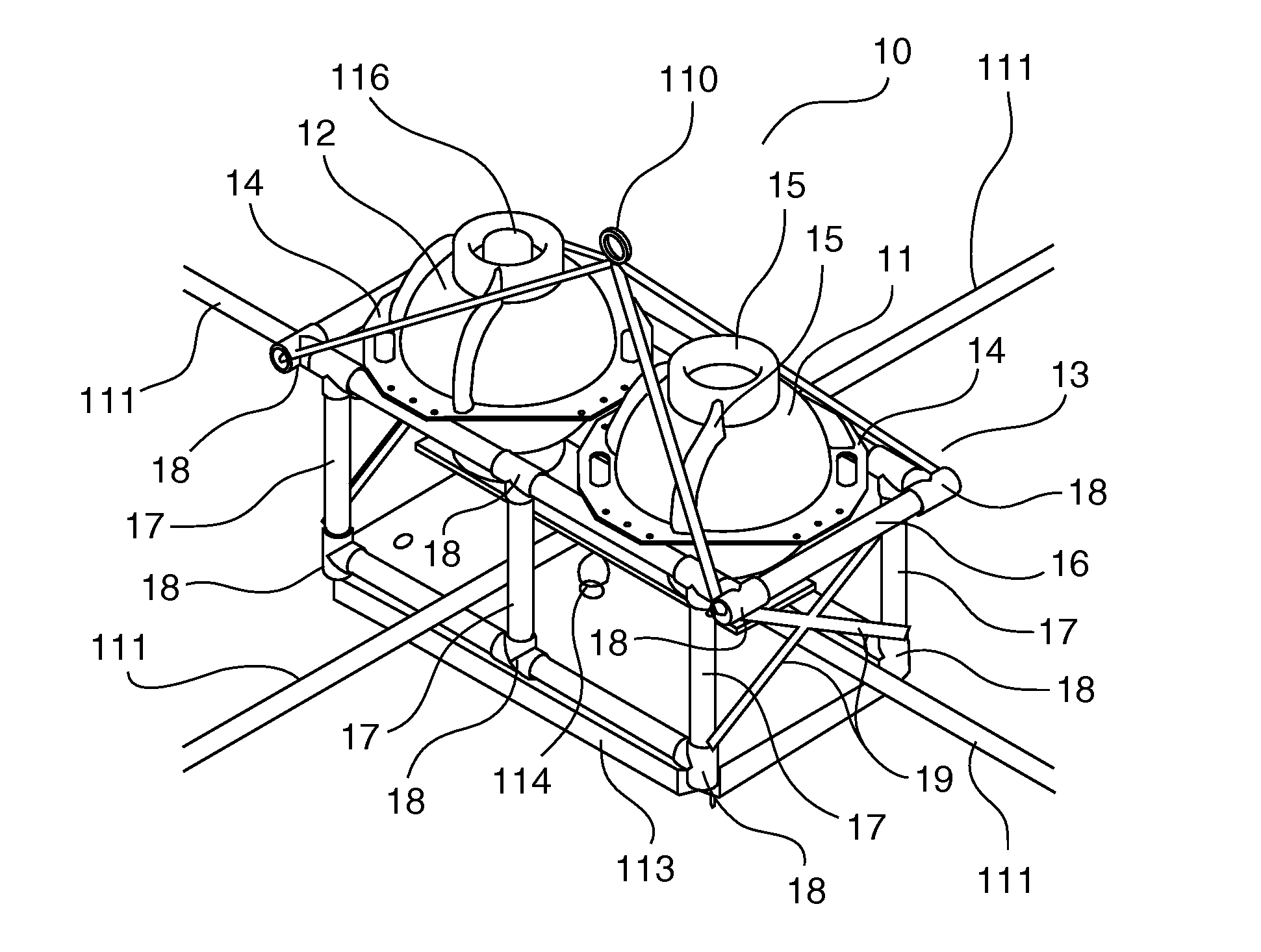
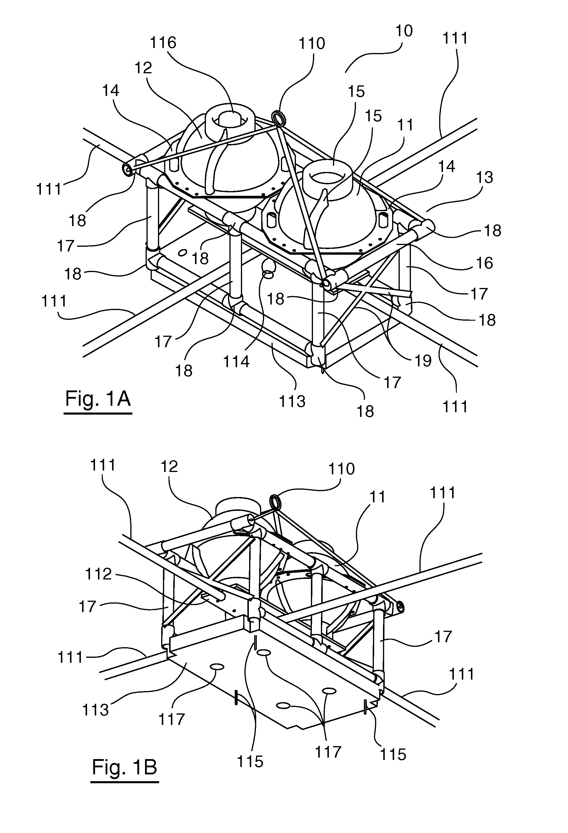
[0060]As already mentioned, an embodiment of the invention is advantageously a geophysical measurement device for the exploration of natural soil resources in an aquatic environment. The embodiment, described hereinafter, relates to a device intended in particular for deep-sea oil prospecting and comprising two floatability caissons, as illustrated in FIGS. 1A and 1B, in a top and bottom perspective view, respectively.

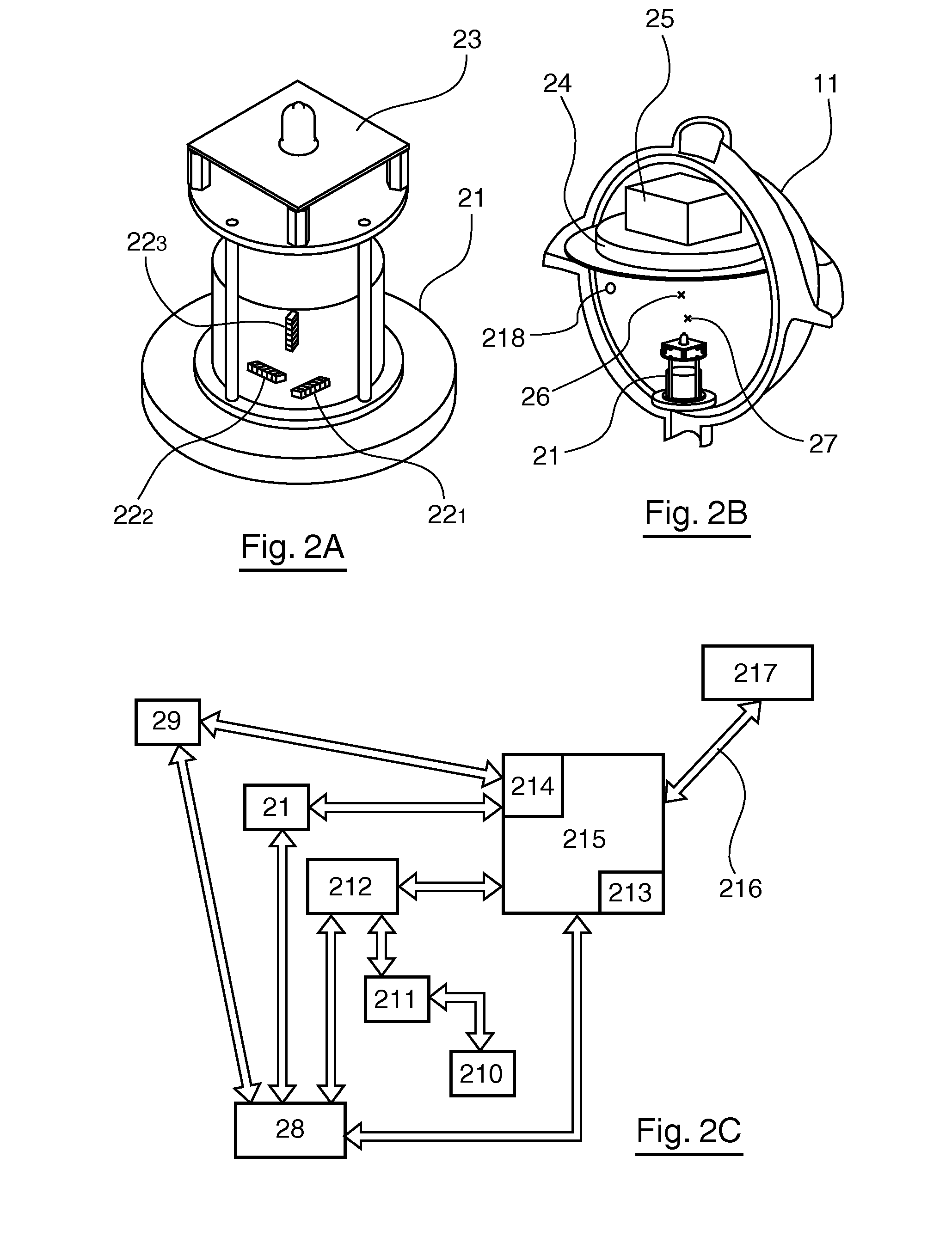
[0061]The geophysical measurement device 10 comprises a first floatability caisson 11, containing a magnetic sensor, also referred to as a magnetometer, and a second floatability caisson 12 mounted on a tubular structure supporting frame 13. The two watertight caissons 11 and 12 are identical in this embodiment. These caissons 11 and 12 are substantially spherical in shape overall, this specific shape enables the walls of the caisson to withstand the hydrostatic pressure up to a depth of six thousand metres. The caissons consist of a glass sphere, not represented in FI...


PUM


Abstract

A geophysical measurement device is provided for exploration of natural resources of the floor in an aquatic domain. The device includes a frame designed to rest in a stable manner on the floor of the aquatic environment, at least one buoyancy caisson resting on the frame, measurement instruments. The measurement instruments including: at least one sensor making it possible to measure locally at least one of the components of the magnetic field; an analogue and / or digital data acquisition and processing device; and a source of energy supply of the sensor and of the data acquisition and processing device. The at least one sensor is contained inside the buoyancy caisson.

Description

CROSS-REFERENCE TO RELATED APPLICATIONS[0001]This Application is a Section 371 National Stage Application of International Application No. PCT / EP2007 / 050192, filed Jan. 9, 2007 and published as WO 2007 / 080167A1 on Jul. 19, 2007, not in English.STATEMENT REGARDING FEDERALLY SPONSORED RESEARCH OR DEVELOPMENT[0002]None.THE NAMES OF PARTIES TO A JOINT RESEARCH AGREEMENT[0003]None.FIELD OF THE DISCLOSURE[0004]The field of the disclosure is that of the exploration of the geophysical properties of the subsoil of an aquatic environment.[0005]More specifically, the disclosure relates to a measurement device used to define, on the basis of a magnetotelluric approach, mapping of the electrical conductivity distribution of the subsoil of such an environment, particularly in a marine environment. The disclosure is intended more specifically to be implemented within the scope of prospecting projects prior to the operation of the natural resources in the subsoil, and particularly in the location o...

Claims


Application Information

Patent Timeline
IPC IPC(8): G01V3/08
CPCG01V3/15
Inventor D'EU, JEAN-FRANCOISCAIRNS, GRAEMETARITS, PASCALJEGEN-KULCSAR, MARIONDUBREULE, ALAIN
Owner UNIV DE BRETAGNE OCCIDENTALE
Why Eureka
Try Eureka