Real-Time Remote-Viewing Digital Compass

a digital compass and real-time remote viewing technology, applied in the field of automotive telematics and mobile telephony, can solve the problems of reducing the effect of prisoner's dilemma among drivers, affecting the use of vehicles, and viewers under the burden of such chores, so as to encourage the utilization of unused resources

Active Publication Date: 2011-05-26
ERGONOTECH
View PDF4 Cites 14 Cited by
  • Summary
  • Abstract
  • Description
  • Claims
  • Application Information

AI Technical Summary

Benefits of technology

[0026]The main advantage of the invention is that it can harness the vehicle traffic to stream real-time traffic scenes to motorists on a peer-to-peer basis and in the way they wanted, bottom up, not top down, as opposed to smart sensor networks and Intelligent Transportations Systems that may tend to compromise some user-centric needs in view of their proprietary nature. Particularly, it is aimed at encouraging the utilization of unused resources like television-band white spaces, i.e. idle frequency spectrums between TV channels, to synergize the peer-to-peer efficiency and the said unlicensed airwaves.
[0027]Admitting that the 3D digital maps, like Google's Street View, are more instructive and clearer when it comes to turn-by-turn navigation guidance, 3D maps in general are of proprietary nature in terms of cartographic update needs and may have to cope with privacy risks, on top of the constant updating needs and related maintenance expenses. This will make 3D maps unlikely to show most up-to-date street scenes, where the most up-to-date images are critical.
[0028]The fundamental nature of vehicle traffic as a form of fluid dynamics is often overlooked. The hard fact that one driver can help improve traffic can also mean the same driver can wreak havoc on the traffic devastatingly. Therefore, the detrimental effects of blind competition among drivers, which can cause a butterfly effect leading up to a ‘phantom jam’, can be mitigated remarkably by the invention, because it can provide an optimal solution to motorists' road anxiety and uncertainty lying ahead on the roads by effectuating real-time viewing of remote scenes on the roads ahead. The user-centric feature of this remote viewing capability will help balance out any possible chaotic and panicky traffic surges (analogous to a butterfly effect) that might result from top-down propagation of underpriotized and commercially weighted traffic news updates and guidance.
[0029]In view that any real-time traffic data of proprietary nature disseminated by local traffic authority or other private or public service entity may compromise the originally intended efficiency of the traffic data thus disseminated, whereas the peer-to-peer nature of remote-viewing will alternatively enhance each motorists SI (Swarm Intelligence) initiatives to avoid any possible chaotic traffic surges by beating the road anxiety resulting from being unable to see beyond the limits of human eyes.
[0030]FIG. 1.1 Default Dial of Digital Compass
[0031]The compass in the background illustrates 16 directions. Each of the four coaxial circles represents the distance indicated in terms of mileage, with the exception of the circle for 4+, which represents distances between 4 to 50 miles. A user can select the desired distance first by depressing a corresponding circle and continuing to run the depressing finger toward a desired direction.

Problems solved by technology

Basically, being unable to see far beyond from a driver's driving point may tend to prime the negative effect of Prisoner's Dilemma among drivers on the roads, especially at the time of an abrupt traffic surge.
Accordingly, the controversial issue of privacy would need to be compromised considerably if it were to mandate VDERs to be installed all across the board without a single exception.
In this case, the main drawback is that viewers are under the burden of such chores as log-in procedures to get access to the limited number of webcam installations.
Additionally, iCam is basically a one-to-one communication device lacking a peer-to-peer advantage of harnessing the vehicle traffic.

Method used


Image

  • Real-Time Remote-Viewing Digital Compass
  • Real-Time Remote-Viewing Digital Compass
  • Real-Time Remote-Viewing Digital Compass

Examples


Embodiment Construction

[0085]The preferred embodiment of the present invention requires being embedded primarily into such stationary mobile equipment as an in-dash navigator as a complementary feature of an all-inclusive telematics device. Alternatively, such portable handsets and other portable devices with touchscreens like laptops, netbooks, and tablet PCs may incorporate this invention as an application software as well. Also inclusive in the desirable embodiment option is such a hybrid mobile device that can be both portable and detachable for vehicle-mount.

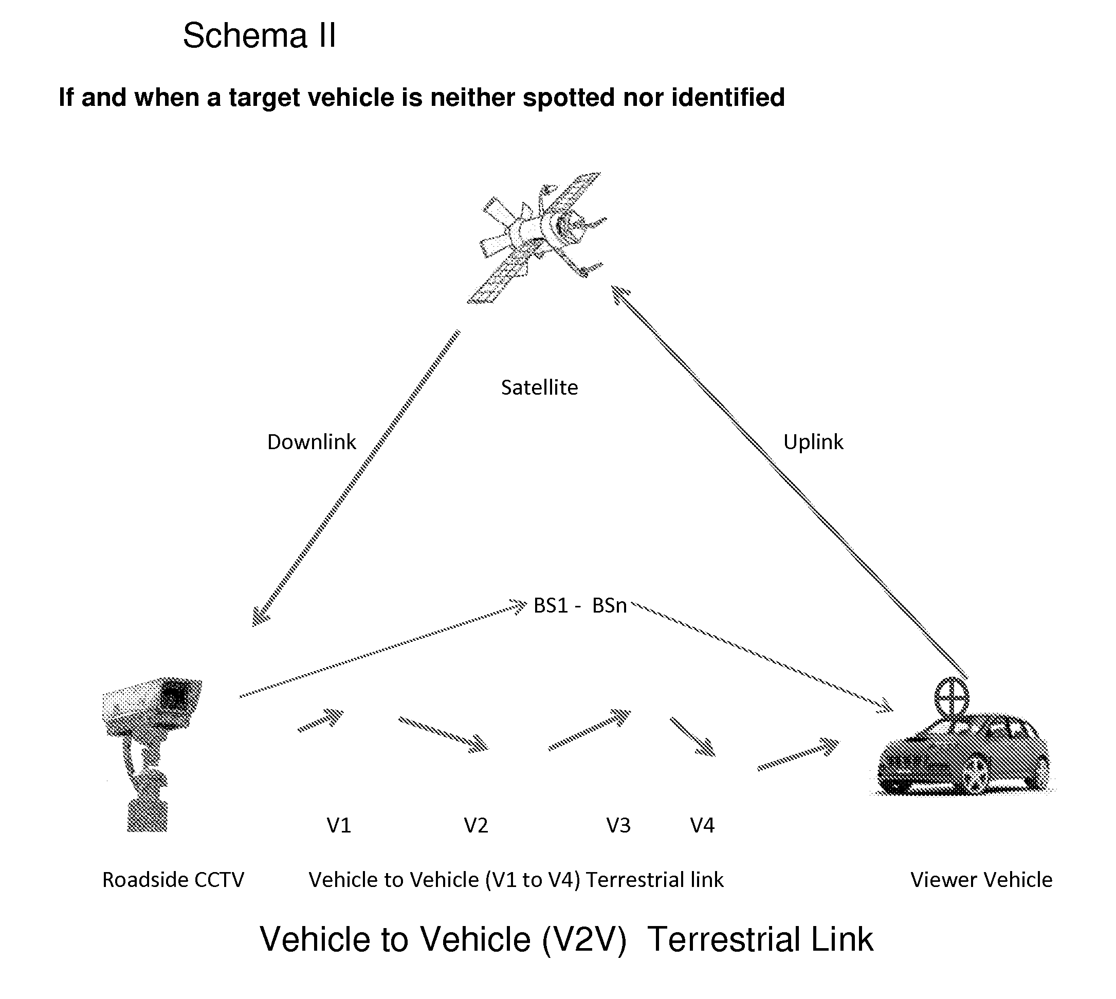
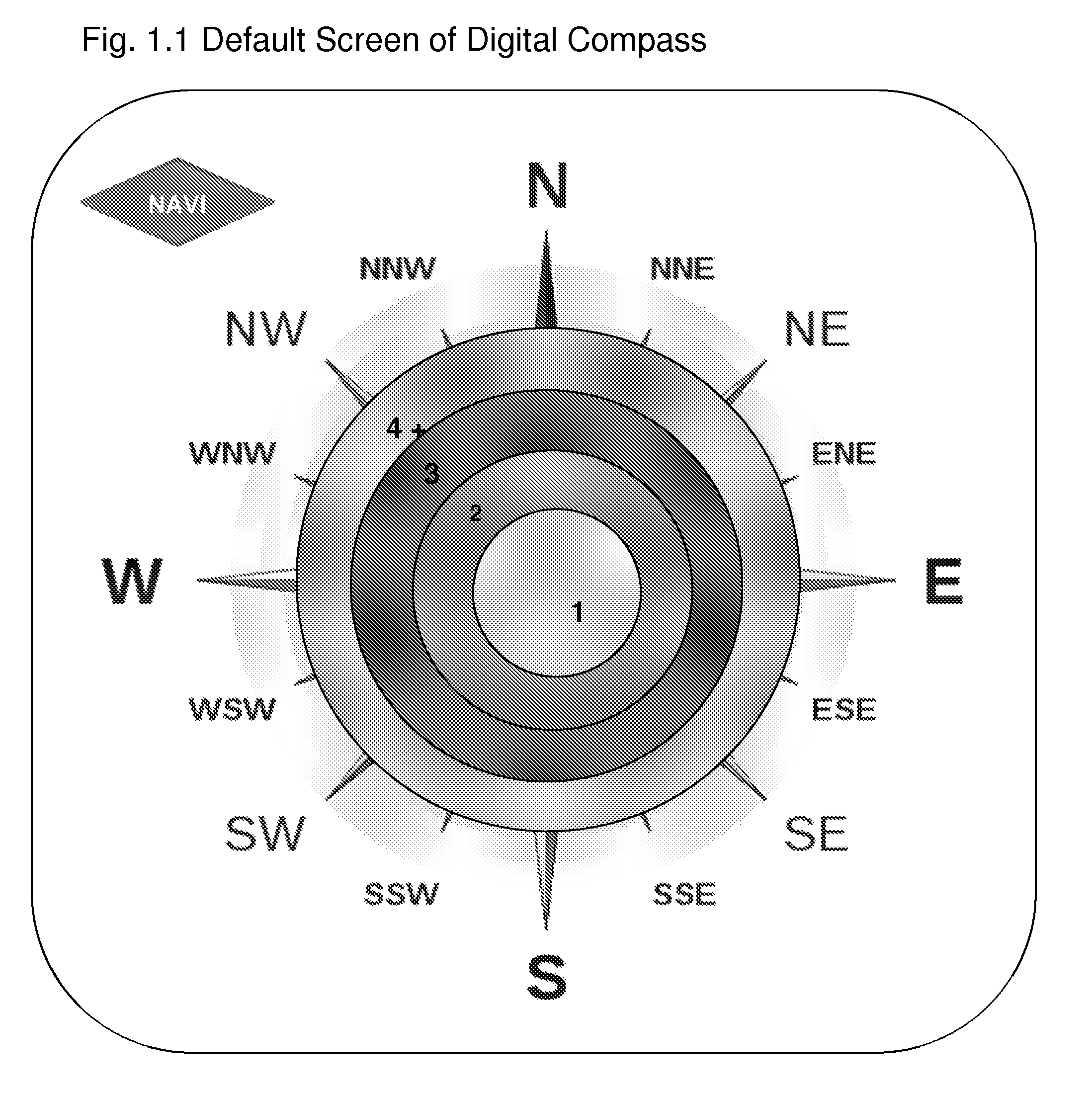
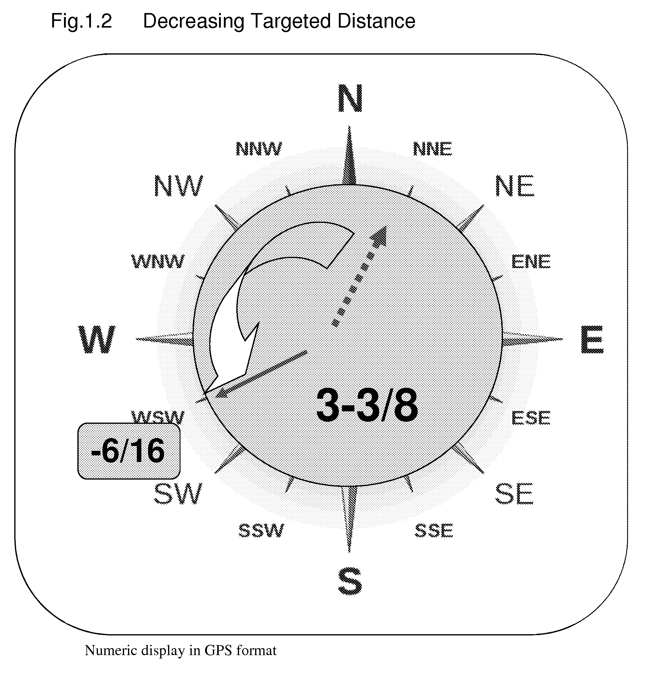
[0086]To implement this invention, a navigator screen can be so designed as to add new menu options: Self-View, Tap-View and Remote-View. Self-View enables a viewer / driver to see video images created through the viewer's own vehicle, whereas Remote-View is meant to help a viewer / driver see real-time remote scenes through targeted vehicles, by directing a targeted distance and direction on a digital compass. While on a navigation screen, a viewer / ...


PUM


Abstract

Vehicle-mounted video cameras, if and when wirelessly connected via a hybrid transceiver of satellite and terrestrial links and either through a randomly-formed vehicle-to-vehicle network, or via mobile web links, may enable motorists behind the wheel to remotely see either on a navigator screen, or on a screen of mobile equipment, inclusive of handsets and tablet PCs, any real-time video images of traffic and/or street scenes, far beyond physical limits of human eyesight. In pursuing the said peer-to-peer advantages, the real-time street views targeted in any directions can be picked at the discretion of motorists, by transmitting the location-based inquiry to the targeted on-vehicle cameras, by tapping on an in-vehicle touchscreen or a mobile device screen and also by activating voice commands, if necessary. The viewable range and directions are only affected or limited by the signal strength based on the density of moving vehicles in between and the availability of interconnected roadside stationary surveillance fixtures as well as the availability of target vehicles equipped with video cameras.

Description

CROSS-REFERENCE TO RELATED APPLICATIONS[0001]NoneSTATEMENT REGARDING FEDERALLY SPONSORED RESEARCH AND DEVELOPMENT[0002]Not availableTHE NAMES OF THE PARTIES TO A JOINT RESEARCH AGREEMENT[0003]Not availableINCORPORATION-BY-REFERENCE OF SEQUENCE LISTING SUBMITTED[0004](1) Glossary[0005](2) Self-View[0006](3) Remote-View[0007](4) Tap-View[0008](5) NAVI[0009](6) Multipup[0010](7) Targeting HierachyBACKGROUND OF THE INVENTION[0011](1) Field of the Invention[0012]The present invention pertains to automotive telematics and mobile telephony focused on machine-to-machine (M2M) communications.[0013](2) Description of the Related Art[0014]Automotive navigation is being widespread with digital maps gradually shifting away from 2D to 3D. The conventional 2D and 3D digital maps, such as Google Maps and Street View, are devoid of real-time features that would enhance motorists' chances of making user-centric driving decisions in a way to avoid mutually exclusive driving behaviors.[0015]Basically, ...

Claims


Application Information

Patent Timeline
Patent Type & Authority Applications(United States)
IPC IPC(8): H04N7/18H04N7/20G06F3/048
CPCH04N7/20H04N7/183
Inventor CHO, KYU HWANG
Owner ERGONOTECH
Why Eureka
Try Eureka